Restaurant nearby פלאפל גלעדי
Israel
Restaurant nearby פלאפל גלעדי
פלאפל גלעדי
32, הנביאים, פתח תקווה, פתח תקווה, IL ישראל
contacts phone
:
+972 3-930-8283
Latitude:
32.073267
, Longitude:
34.8983511
larger map & directions
read more
nearest Restaurant
39 m
מאמי'ס
הנביאים 47, פתח תקווה
Restaurant
read more
200 m
חומוס הנביאים
HaNevi'im Street 31, Petah Tikva
Restaurant
read more
220 m
שניצל בננה
יונה גרין 7, פתח תקווה
Restaurant
read more
220 m
שניצל בננה
Yona Grin Street 7, Petah Tikva
Restaurant
read more
428 m
הפלאפל של אבא
Ha-Khamisha Street 7, Petah Tikva
Restaurant
read more
428 m
הפלאפל של אבא
החמישה 7, פתח תקווה
Restaurant
read more
495 m
קניון בקיוסק
Henrietta Szold Street 27, Petah Tikva
Restaurant
read more
789 m
Burgeranch
קניון סירקין, פרידמן אלעזר 9, פתח תקווה
Restaurant
read more
791 m
הנריס
Elazar Fridman Street 9, Petah Tikva
Restaurant
Food
Point of interest
Establishment
read more
796 m
שניצל פור יו
Elazar Fridman Street 9, Petah Tikva
Restaurant
read more
823 m
Pizza
אלעזר פרידמן 9, פתח תקווה
Restaurant
read more
823 m
Pizza
Elazar Fridman Street 9, Petah Tikva
Restaurant
read more
833 m
Burgeranch
אלעזר פרידמן 9, פתח תקווה
Restaurant
read more
1.078 km
אצל מזרחי
פתח תקווה
Restaurant
read more
1.08 km
מריק
אורלנסקי 30, פתח תקווה
Restaurant
read more
1.388 km
Crumbs Pizza
Herman Zvi Shapira Street 39, Petah Tikva
Restaurant
read more
1.559 km
מסעדת סבבה
הסדנה 2, פתח תקווה
Restaurant
read more
1.924 km
שאבעס מלאבס
Herzl Street 7, Petah Tikva
Restaurant
read more
1.927 km
פלאפל ירושלים
Hahistadrut Street, Petah Tikva
Restaurant
read more
1.935 km
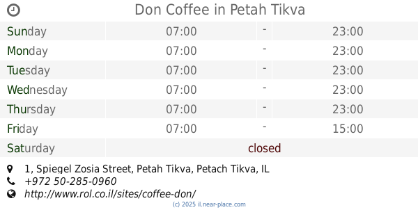
Don Coffee
Spiegel Zosia Street 1, Petah Tikva
Restaurant
read more
2.158 km
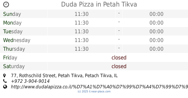
Duda Pizza
Rothschild Street 77, Petah Tikva
Restaurant
read more
2.205 km
האקדמיה אקספרס
יהושע שטמפפר 20, פתח תקווה
Restaurant
read more
2.232 km
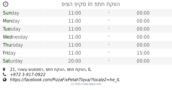
פיצה פיקס
יהושע שטמפפר 21, פתח תקווה
Restaurant
read more
2.307 km
מסעדת באשה
ברון הירש 26, פתח תקווה
Restaurant
read more
2.45 km
שיפודי הכהנים
Ze'ev Lipkis Street 8, Petah Tikva
Restaurant
read more
📑
all categories
Accounting
Administrative area level 1
Administrative area level 2
Airport
Amusement park
Aquarium
Art gallery
Atm
Bakery
Bank
Bar
Beauty salon
Bicycle store
Book store
Bowling alley
Bus station
Cafe
Campground
Car dealer
Car rental
Car repair
Car wash
Casino
Cemetery
Church
City hall
Clothing store
Colloquial area
Convenience store
Country
Courthouse
Dentist
Department store
Doctor
Electrician
Electronics store
Embassy
Establishment
Finance
Fire station
Florist
Food
Funeral home
Furniture store
Gas station
General contractor
Grocery or supermarket
Gym
Hair care
Hardware store
Health
Hindu Temple
Home goods store
Hospital
Insurance agency
Intersection
Jewelry store
Laundry
Lawyer
Library
Light rail station
Liquor store
Local government office
Locality
Locksmith
Lodging
Meal delivery
Meal takeaway
Mosque
Movie rental
Movie theater
Moving company
Museum
Natural feature
Neighborhood
Night club
Painter
Park
Parking
Pet store
Pharmacy
Physiotherapist
Place of worship
Plumber
Point of interest
Police
Political
Post office
Premise
Real estate agency
Restaurant
Roofing contractor
Route
Rv park, camping
School
Shoe store
Shopping mall
Spa
Stadium
Storage
Store
Subpremise
Subway station
Supermarket
Synagogue
Taxi stand
Train station
Transit station
Travel agency
University
Veterinary care
Zoo
administrative area level 3
administrative area level 4
sublocality level 1
↑