Restaurant nearby פלאפל אבו אל-אמין
Israel
Restaurant nearby פלאפל אבו אל-אמין
פלאפל אבו אל-אמין
Ибилин, Израиль
contacts phone
:
+972
Latitude:
32.8262628
, Longitude:
35.1855338
larger map & directions
read more
nearest Restaurant
פלאפל אבו אל-אמין
אעבלין
Restaurant
read more
269 m
Arozna Restaurant
אעבלין
Restaurant
read more
269 m
Arozna Restaurant
I'billin
Restaurant
read more
287 m
Restaurant Abu Amr
I'billin
Restaurant
read more
287 m
מסעדת אבו עמר
אעבלין
Restaurant
read more
372 m
مطعم الروزانا
I'billin
Restaurant
read more
380 m
מסעדת מפגש הגליל
Unnamed Rd I'billin
Restaurant
read more
716 m
מסעדת אלמולתאקא עבלין
אעבלין
Restaurant
read more
720 m
בגיט אליונס - باجيت اليونس
I'billin
Restaurant
read more
720 m
בגיט אליונס - باجيت اليونس
אעבלין
Restaurant
read more
1.122 km
Back To Black Bar & Restaurant
אעבלין
Restaurant
read more
2.187 km
مخبز وميني ماركت الفانوس
230،, Shefa-'Amr
Restaurant
Food
Point of interest
Establishment
read more
2.402 km
מסעדת רותאנא
Shefa-'Amr
Restaurant
read more
2.553 km
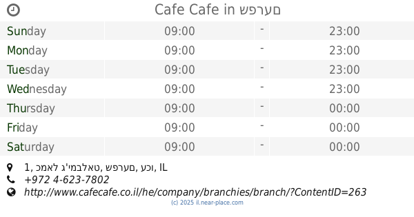
Cafe Cafe
כמאל ג'ימבלאט 1, שפרעם
Cafe
Restaurant
Food
Store
Point of interest
Establishment
read more
2.575 km
פלאפל פהים
שפרעם
Restaurant
read more
2.575 km
פלאפל פהים
Shefa-'Amr
Restaurant
read more
2.58 km
בורקס ופיצה הכיכר
Kamal Jumblatt, Jabur Yusef Jabur Street, Shefa-'Amr
Restaurant
Food
Point of interest
Establishment
read more
2.581 km
מסעדת בית גדי
Shefa-'Amr
Restaurant
read more
2.581 km
מסעדת בית גדי
שפרעם
Restaurant
read more
2.583 km
مطعم تيتي מסעדת תיתי TT Restaurant
Kamal Junbalat Street, Shefa-'Amr
Restaurant
Food
Point of interest
Establishment
read more
2.585 km
מסעדת בית גדי
Kamal Junbalat Street, Shefa-'Amr
Restaurant
Point of interest
Food
Establishment
read more
2.63 km
منتزه الجليل
I'billin
Restaurant
read more
2.703 km
מסעדת סיידה
Shefa-'Amr
Restaurant
read more
2.726 km
מסעדתגני הגליל טמרה
I'billin
Restaurant
read more
3.115 km
Shawamburger
Shefa-'Amr
Restaurant
read more
📑
all categories
Accounting
Administrative area level 1
Administrative area level 2
Airport
Amusement park
Aquarium
Art gallery
Atm
Bakery
Bank
Bar
Beauty salon
Bicycle store
Book store
Bowling alley
Bus station
Cafe
Campground
Car dealer
Car rental
Car repair
Car wash
Casino
Cemetery
Church
City hall
Clothing store
Colloquial area
Convenience store
Country
Courthouse
Dentist
Department store
Doctor
Electrician
Electronics store
Embassy
Establishment
Finance
Fire station
Florist
Food
Funeral home
Furniture store
Gas station
General contractor
Grocery or supermarket
Gym
Hair care
Hardware store
Health
Hindu Temple
Home goods store
Hospital
Insurance agency
Intersection
Jewelry store
Laundry
Lawyer
Library
Light rail station
Liquor store
Local government office
Locality
Locksmith
Lodging
Meal delivery
Meal takeaway
Mosque
Movie rental
Movie theater
Moving company
Museum
Natural feature
Neighborhood
Night club
Painter
Park
Parking
Pet store
Pharmacy
Physiotherapist
Place of worship
Plumber
Point of interest
Police
Political
Post office
Premise
Real estate agency
Restaurant
Roofing contractor
Route
Rv park, camping
School
Shoe store
Shopping mall
Spa
Stadium
Storage
Store
Subpremise
Subway station
Supermarket
Synagogue
Taxi stand
Train station
Transit station
Travel agency
University
Veterinary care
Zoo
administrative area level 3
administrative area level 4
sublocality level 1
↑