Restaurant nearby מסעדת שמש
Israel
Restaurant nearby מסעדת שמש
מסעדת שמש
שוק התקווה, התקווה 13, תל אביב יפו Israel
contacts phone
:
+972
Latitude:
32.0530148
, Longitude:
34.7904061
read more
nearest Restaurant
21 m
פול'ס - חומוס, פול, מסבחה
HaTikva Street 10, Tel Aviv-Yafo
Restaurant
read more
21 m
פול'ס - חומוס, פול, מסבחה
התקווה 10, תל אביב יפו
Restaurant
read more
41 m
מסעדת שאול מוצפי ובניו
מבשר 15, תל אביב יפו
Restaurant
read more
66 m
אצל ניסים
מבשר 3, תל אביב יפו
Restaurant
read more
93 m
The Yemenite House
האצ"ל 13, Tel Aviv-Yafo
Restaurant
read more
93 m
מסעדת הבית התימני
האצ"ל 13, תל אביב יפו
Restaurant
read more
110 m
שווארמה ההגנה
Hagana Road 80, Tel Aviv-Yafo
Restaurant
read more
121 m
Wok The Asian Way
Hagana Road 84, Tel Aviv-Yafo
Restaurant
read more
178 m
בוסי מסעדת גריל ישראלי
אצ"ל 41, תל אביב יפו
Restaurant
read more
221 m
ושבעת וברכת
אצ"ל 47, תל אביב יפו
Restaurant
read more
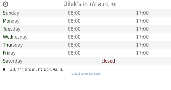
384 m
Dilek's
דרך ההגנה 33, תל אביב יפו
Restaurant
read more
400 m
המרקים של כרמלה
Etsel Street 58, Tel Aviv-Yafo
Restaurant
read more
543 m
ווק טו ווק שרונה מרקט
מגן קלמן 3 תל אביב
Restaurant
read more
545 m
פיצה גולדה
83, Etsel Street, Tel Aviv-Yafo
Restaurant
read more
918 m
מקדונלד'ס יד אליהו
היכל מנורה מבטחים, יגאל אלון 51, תל אביב יפו
Restaurant
read more
938 m
Ilans coffee
Yigal Alon Street 51, Tel Aviv-Yafo
Restaurant
read more
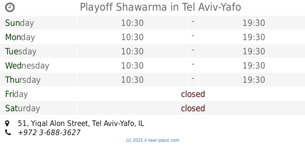
949 m
Playoff Shawarma
Yigal Alon Street 51, Tel Aviv-Yafo
Restaurant
read more
1.12 km
Chinese Bao Buns
נווה שאנן 26, תל אביב יפו
Restaurant
read more
1.12 km
Chinese Bao Buns
Neve Sha'anan Street 26, Tel Aviv-Yafo
Restaurant
read more
1.176 km
לה גרדיה גריל בר
לה גרדיה 76, תל אביב יפו
Restaurant
read more
1.176 km
Yummy Sudanese Restaurant
נווה שאנן 20, תל אביב יפו
Restaurant
read more
1.194 km
שניצליין
Yad Harutsim Street 13, Tel Aviv-Yafo
Restaurant
read more
1.196 km
קופי בר
יד חרוצים 13, תל אביב יפו
Restaurant
read more
1.2 km
Traktir
יד חרוצים 13, תל אביב יפו
Restaurant
read more
1.207 km
ד"ר חכים
Yegi'a Kapayim Street 1, Tel Aviv-Yafo
Restaurant
read more
📑
all categories
Accounting
Administrative area level 1
Administrative area level 2
Airport
Amusement park
Aquarium
Art gallery
Atm
Bakery
Bank
Bar
Beauty salon
Bicycle store
Book store
Bowling alley
Bus station
Cafe
Campground
Car dealer
Car rental
Car repair
Car wash
Casino
Cemetery
Church
City hall
Clothing store
Colloquial area
Convenience store
Country
Courthouse
Dentist
Department store
Doctor
Electrician
Electronics store
Embassy
Establishment
Finance
Fire station
Florist
Food
Funeral home
Furniture store
Gas station
General contractor
Grocery or supermarket
Gym
Hair care
Hardware store
Health
Hindu Temple
Home goods store
Hospital
Insurance agency
Intersection
Jewelry store
Laundry
Lawyer
Library
Light rail station
Liquor store
Local government office
Locality
Locksmith
Lodging
Meal delivery
Meal takeaway
Mosque
Movie rental
Movie theater
Moving company
Museum
Natural feature
Neighborhood
Night club
Painter
Park
Parking
Pet store
Pharmacy
Physiotherapist
Place of worship
Plumber
Point of interest
Police
Political
Post office
Premise
Real estate agency
Restaurant
Roofing contractor
Route
Rv park, camping
School
Shoe store
Shopping mall
Spa
Stadium
Storage
Store
Subpremise
Subway station
Supermarket
Synagogue
Taxi stand
Train station
Transit station
Travel agency
University
Veterinary care
Zoo
administrative area level 3
administrative area level 4
sublocality level 1
↑