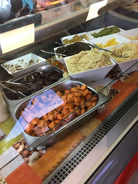
Restaurant nearby מסעדה נור יפו
Israel
Restaurant nearby מסעדה נור יפו
מסעדה נור יפו
יפת פינת עמיעד, Tel Aviv-Yafo Israel
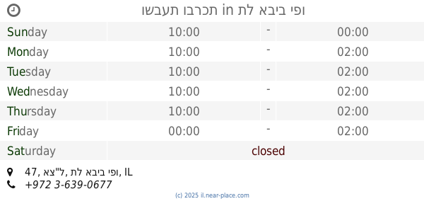
contacts phone
:
+972
Latitude:
32.034714
, Longitude:
34.799192
read more
nearest Restaurant
מסעדה נור יפו
יפת, תל אביב יפו
Restaurant
read more
מסעדה נור יפו
יפת פינת עמיעד, תל אביב יפו
Restaurant
read more
478 m
אורוגולה
HaShikma Street 5, Azor
Restaurant
read more
544 m
ציקן ביף
Ha-Metsuda Street 10, Azor
Restaurant
read more
588 m
טורטיה בר אזור
Ha-Metsuda Street 8, Azor
Restaurant
read more
588 m
טורטיה בר אזור
המצודה 8, אזור
Restaurant
read more
596 m
חומוס אליהו
המצודה 8, אזור
Restaurant
read more
596 m
פיצה ברקה
Ha-Metsuda Street 8, Azor
Restaurant
read more
597 m
טורטיה בר
המצודה 4-8, אזור
Restaurant
read more
597 m
טורטיה בר
המצודה 4-8, Azor
Restaurant
read more
652 m
מסעדה ראמן
34332, 44
Restaurant
read more
798 m
Shawarma Daboosh
מתחם תחנת דלק מבוא שומרון, Derech HaShiv'a 20, Holon
Restaurant
Food
Point of interest
Establishment
read more
809 m
Shawarma Daboosh
מתחם תחנת דלק מבוא שומרון, דרך השבעה 20, חולון
Restaurant
read more
809 m
שווארמה דבוש
מתחם תחנת דלק מבוא שומרון, דרך השבעה 20, חולון
Restaurant
read more
1.103 km
שמחה קולינארית
שפרינצק 12, אזור
Restaurant
read more
1.399 km
Yhudit
Ha-Sadna Street 17, Holon
Restaurant
read more
1.472 km
Hai Phong - Chinese Restaurant
HaPeled Street 20, Holon
Restaurant
read more
1.654 km
פיצה גולדה
83, Etsel Street, Tel Aviv-Yafo
Restaurant
read more
1.658 km
ווק טו ווק שרונה מרקט
מגן קלמן 3 תל אביב
Restaurant
read more
1.797 km
המרקים של כרמלה
Etsel Street 58, Tel Aviv-Yafo
Restaurant
read more
1.906 km
חומוסוקולוב
סוקולוב 138, חולון
Restaurant
read more
1.92 km
Shawarma taboon
Ha-Melakha Street 19, Holon
Restaurant
read more
1.982 km
ושבעת וברכת
אצ"ל 47, תל אביב יפו
Restaurant
read more
2.032 km
בוסי מסעדת גריל ישראלי
אצ"ל 41, תל אביב יפו
Restaurant
read more
2.659 km
שיפודי חן
Malki Tsedek Street 23, Ramat Gan
Restaurant
read more
📑
all categories
Accounting
Administrative area level 1
Administrative area level 2
Airport
Amusement park
Aquarium
Art gallery
Atm
Bakery
Bank
Bar
Beauty salon
Bicycle store
Book store
Bowling alley
Bus station
Cafe
Campground
Car dealer
Car rental
Car repair
Car wash
Casino
Cemetery
Church
City hall
Clothing store
Colloquial area
Convenience store
Country
Courthouse
Dentist
Department store
Doctor
Electrician
Electronics store
Embassy
Establishment
Finance
Fire station
Florist
Food
Funeral home
Furniture store
Gas station
General contractor
Grocery or supermarket
Gym
Hair care
Hardware store
Health
Hindu Temple
Home goods store
Hospital
Insurance agency
Intersection
Jewelry store
Laundry
Lawyer
Library
Light rail station
Liquor store
Local government office
Locality
Locksmith
Lodging
Meal delivery
Meal takeaway
Mosque
Movie rental
Movie theater
Moving company
Museum
Natural feature
Neighborhood
Night club
Painter
Park
Parking
Pet store
Pharmacy
Physiotherapist
Place of worship
Plumber
Point of interest
Police
Political
Post office
Premise
Real estate agency
Restaurant
Roofing contractor
Route
Rv park, camping
School
Shoe store
Shopping mall
Spa
Stadium
Storage
Store
Subpremise
Subway station
Supermarket
Synagogue
Taxi stand
Train station
Transit station
Travel agency
University
Veterinary care
Zoo
administrative area level 3
administrative area level 4
sublocality level 1
↑