Restaurant nearby MEAT STOP
Israel
Restaurant nearby MEAT STOP
MEAT STOP
20, Derech Ben Gurion, Ramat Gan, IL Israel
contacts phone
:
+972 3-674-7878
website:
www.meatstop.co.il
Latitude:
32.0938085
, Longitude:
34.8218966
larger map & directions
read more
nearest Restaurant
176 m
בהדונס החומוס והפול
Nili Street 1, Bnei Brak
Restaurant
read more
208 m
מאכלים של אמא
דרך בן גוריון 34, רמת גן
Restaurant
read more
235 m
Lunch Box
כינרת 5, בני ברק
Restaurant
read more
314 m
Agvania Pizza
Ze'ev Jabotinsky Road 155, Ramat Gan
Restaurant
read more
376 m
טוסט נקניק
Ze'ev Jabotinsky Street 12, Bnei Brak
Restaurant
read more
381 m
חומוס אליהו
הירקון 10, בני ברק
Restaurant
read more
396 m
Эль Гаучо
ז’בוטינסקי 134, רמת גן
Restaurant
read more
425 m
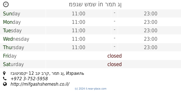
מפגש שמש
זבוטינסקי 12 בני ברק, רמת גן
Restaurant
read more
481 m
פלאפל דני
Derech Sheshet HaYamim, Bnei Brak
Restaurant
read more
675 m
Burgeranch
Derech Aba Hillel 301, Ramat Gan
Restaurant
read more
722 m
Curryliina's
הירקון 42, בני ברק
Restaurant
read more
725 m
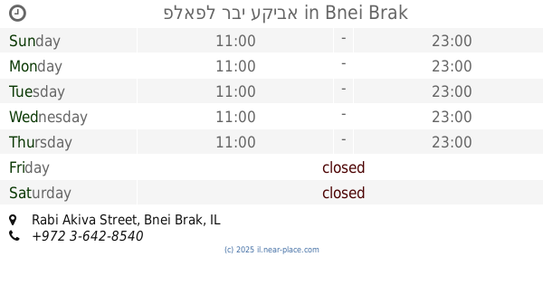
פלאפל רבי עקיבא
31, Rabi Akiva Street, Bnei Brak
Restaurant
read more
750 m
הפלאפל של דוד בהנהלת יוסי
הירקון 45, בני ברק
Restaurant
read more
800 m
מאפיית פיתות עיראקיות
הרב פתאיה 12, בני ברק
Restaurant
read more
833 m
Rakefet
Ze'ev Jabotinsky Street 99, Ramat Gan
Restaurant
read more
843 m
אגסי
רח' זאב ז'בוטינסקי 99, רמת גן
Restaurant
read more
850 m
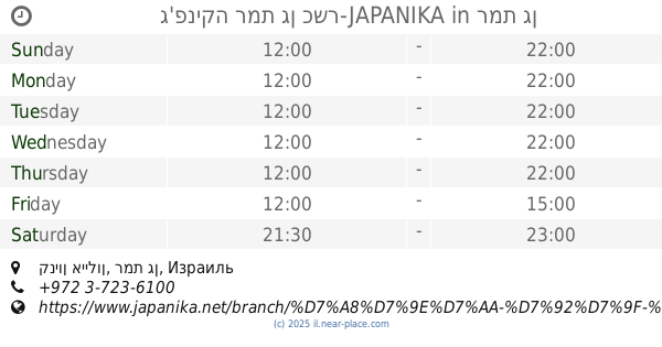
ג'פניקה רמת גן כשר-JAPANIKA
קניון איילון, רמת גן
Restaurant
read more
871 m
שיפודי התקווה
Abba Hillel Silver 301, רמת גן
Restaurant
read more
916 m
עצמון-דליקטס טריפולטאי
מנחם בגין 39, בני ברק
Restaurant
read more
934 m
Tzan'ani restaurant
Ze'ev Jabotinsky Road 92, Bnei Brak
Restaurant
read more
934 m
מסעדת צנעני
רח' זאב ז'בוטינסקי 92, בני ברק
Restaurant
read more
1.019 km
שלייקס אוכל יהודי
HaKishon Street 13, Bnei Brak
Restaurant
read more
1.019 km
Sliiks Jewish food
HaKishon Street 13, Bnei Brak
Restaurant
read more
1.15 km
באגטינו
ירושלים 14, בני ברק
Restaurant
read more
1.153 km
סושיאמי
Ze'ev Jabotinsky Street 75, Ramat Gan
Restaurant
read more
📑
all categories
Accounting
Administrative area level 1
Administrative area level 2
Airport
Amusement park
Aquarium
Art gallery
Atm
Bakery
Bank
Bar
Beauty salon
Bicycle store
Book store
Bowling alley
Bus station
Cafe
Campground
Car dealer
Car rental
Car repair
Car wash
Casino
Cemetery
Church
City hall
Clothing store
Colloquial area
Convenience store
Country
Courthouse
Dentist
Department store
Doctor
Electrician
Electronics store
Embassy
Establishment
Finance
Fire station
Florist
Food
Funeral home
Furniture store
Gas station
General contractor
Grocery or supermarket
Gym
Hair care
Hardware store
Health
Hindu Temple
Home goods store
Hospital
Insurance agency
Intersection
Jewelry store
Laundry
Lawyer
Library
Light rail station
Liquor store
Local government office
Locality
Locksmith
Lodging
Meal delivery
Meal takeaway
Mosque
Movie rental
Movie theater
Moving company
Museum
Natural feature
Neighborhood
Night club
Painter
Park
Parking
Pet store
Pharmacy
Physiotherapist
Place of worship
Plumber
Point of interest
Police
Political
Post office
Premise
Real estate agency
Restaurant
Roofing contractor
Route
Rv park, camping
School
Shoe store
Shopping mall
Spa
Stadium
Storage
Store
Subpremise
Subway station
Supermarket
Synagogue
Taxi stand
Train station
Transit station
Travel agency
University
Veterinary care
Zoo
administrative area level 3
administrative area level 4
sublocality level 1
↑