Restaurant nearby Макдоналдс
Israel
Restaurant nearby Макдоналдс
Макдоналдс
Тамра, Израиль
contacts phone
:
+972 52-944-0037
website:
www.mcdonalds.co.il
Latitude:
32.8624388
, Longitude:
35.1704668
larger map & directions
read more
nearest Restaurant
מקדונלדס
טמרה
Restaurant
read more
5 m
McDonald's
צומת תמרה, Tamra
Restaurant
Food
Point of interest
Establishment
read more
425 m
שוארמה אלחיר
מסעף טמרה, טמרה
Restaurant
read more
425 m
שוארמה אלחיר
מסעף טמרה, Tamra
Restaurant
read more
446 m
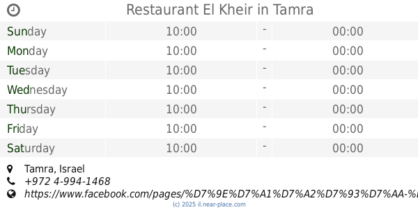
Restaurant El Kheir
Tamra
Restaurant
Food
Point of interest
Establishment
read more
446 m
מסעדת אל ח'יר
טמרה
Restaurant
read more
448 m
ח'ר דיאב
Nesher Intersection, Tamra
Restaurant
read more
461 m
West House
Tamrah, 30811, כניסה ראשי
Restaurant
read more
673 m
מסעדת אבו עלי
Tamra
Restaurant
read more
728 m
אל-טאז׳ג
Tamra
Restaurant
Point of interest
Food
Establishment
read more
728 m
אל-טאז׳ג
טמרה
Restaurant
read more
944 m
מסעדת אלמאס
Tamra
Restaurant
read more
1.172 km
מסעדת כפראיא
Unnamed Road, Tamra
Restaurant
read more
1.172 km
מסעדת כפראיא
Unnamed Road, טמרה
Restaurant
read more
1.181 km
אל-קלעה
Tamra
Restaurant
read more
1.333 km
Alothmani Restaurant
Tamra
Restaurant
read more
1.457 km
מסעדת גני טמרה
טמרה
Restaurant
read more
1.469 km
ابو الهنا בעיר
אל-בירוני, Tamra
Restaurant
Food
Point of interest
Establishment
read more
1.517 km
מסעדת אלנסים (אל-טאזג ישן)
Unnamed Rd, Tamra
Restaurant
read more
1.589 km
בגט ויניציה
Unnamed Rd, Tamra
Restaurant
read more
1.604 km
The opera house
Tamra
Restaurant
read more
1.649 km
غلاتيريا
Unnamed Road, طمرة
Restaurant
read more
1.654 km
חומוס חמודי
כיכר השעון, טמרה
Restaurant
Food
Point of interest
Establishment
read more
2.033 km
مطعم ريان Rayan Resturant
Tamra
Restaurant
Point of interest
Food
Establishment
read more
2.053 km
باجيت حندوقة
باجيت حندوقة, Tamra
Restaurant
Food
Point of interest
Establishment
read more
📑
all categories
Accounting
Administrative area level 1
Administrative area level 2
Airport
Amusement park
Aquarium
Art gallery
Atm
Bakery
Bank
Bar
Beauty salon
Bicycle store
Book store
Bowling alley
Bus station
Cafe
Campground
Car dealer
Car rental
Car repair
Car wash
Casino
Cemetery
Church
City hall
Clothing store
Colloquial area
Convenience store
Country
Courthouse
Dentist
Department store
Doctor
Electrician
Electronics store
Embassy
Establishment
Finance
Fire station
Florist
Food
Funeral home
Furniture store
Gas station
General contractor
Grocery or supermarket
Gym
Hair care
Hardware store
Health
Hindu Temple
Home goods store
Hospital
Insurance agency
Intersection
Jewelry store
Laundry
Lawyer
Library
Light rail station
Liquor store
Local government office
Locality
Locksmith
Lodging
Meal delivery
Meal takeaway
Mosque
Movie rental
Movie theater
Moving company
Museum
Natural feature
Neighborhood
Night club
Painter
Park
Parking
Pet store
Pharmacy
Physiotherapist
Place of worship
Plumber
Point of interest
Police
Political
Post office
Premise
Real estate agency
Restaurant
Roofing contractor
Route
Rv park, camping
School
Shoe store
Shopping mall
Spa
Stadium
Storage
Store
Subpremise
Subway station
Supermarket
Synagogue
Taxi stand
Train station
Transit station
Travel agency
University
Veterinary care
Zoo
administrative area level 3
administrative area level 4
sublocality level 1
↑