Restaurant nearby לימאס מסעדה וקפיטיריה
Israel
Restaurant nearby לימאס מסעדה וקפיטיריה
לימאס מסעדה וקפיטיריה
Unnamed Road، Majd al-Krum, Israel
contacts phone
:
+972 50-558-2968
Latitude:
32.9194625
, Longitude:
35.2635826
larger map & directions
read more
nearest Restaurant
236 m
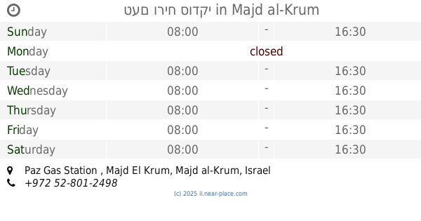
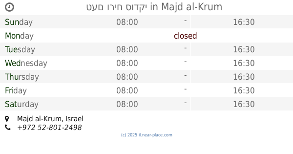
טעם וריח סודקי
Paz Gas Station , Majd El Krum
Restaurant
read more
236 m
טעם וריח סודקי
Israel
Restaurant
Food
Point of interest
Establishment
read more
243 m
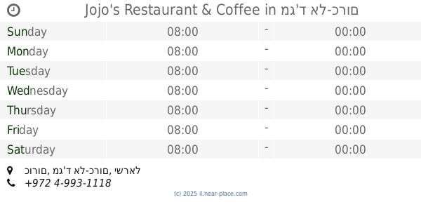
Jojo's Restaurant & Coffee
כורום, מג'ד אל-כרום
Restaurant
read more
415 m
pizza milano
Majd al-Krum
Restaurant
read more
415 m
pizza milano
מג'ד אל-כרום
Restaurant
read more
651 m
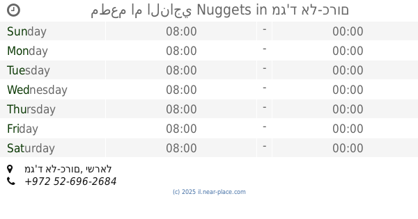
مطعم ام الناجي Nuggets
מג'ד אל-כרום
Restaurant
read more
651 m
مطعم ام الناجي Nuggets
Majd al-Krum
Restaurant
read more
669 m
שווארמה סרחאן
Majd al-Krum
Restaurant
read more
724 m
Hummus Beit Hakerem
Majd al-Krum
Restaurant
read more
724 m
חומוס בית הכרם
מג'ד אל-כרום
Restaurant
read more
1.226 km
מפגש הטעם
Majd al-Krum
Restaurant
read more
1.27 km
קבב הכפר
Majd al-Krum
Restaurant
read more
1.345 km
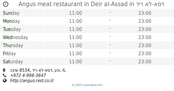
אנגוס בשרים דיר אל אסד
מתחם קניון דבאח, Deir al-Asad
Restaurant
read more
1.362 km
Angus meat restaurant in Deir al-Assad
מתחם קניון דבאח, כביש 8534, דיר אל-אסד
Restaurant
read more
1.603 km
Royal Pizza
El-Shagur Street, Deir al-Asad
Restaurant
read more
1.726 km
מסעדת דיוואן
דיר אל-אסד
Restaurant
read more
1.726 km
Diwan Restaurant
Deir al-Asad
Restaurant
read more
1.726 km
שוארמה האני החדש
דיר אל-אסד
Restaurant
read more
1.762 km
Beit dolev
Tzurit, Zurit
Restaurant
read more
1.769 km
פיצה מאמא מיה
אל שאגור, בענה
Restaurant
read more
1.769 km
פיצה מאמא מיה
El-Shagur Street, Bi'ina
Restaurant
Food
Point of interest
Establishment
read more
1.799 km
מסעדת מאכלי מלכים
דיר אל אסד
Restaurant
read more
1.8 km
בית דולב
Tzurit
Restaurant
read more
1.8 km
בית דולב
צורית
Restaurant
read more
2.465 km
פיצה עדן
הפלמ"ח 16, כרמיאל
Restaurant
read more
📑
all categories
Accounting
Administrative area level 1
Administrative area level 2
Airport
Amusement park
Aquarium
Art gallery
Atm
Bakery
Bank
Bar
Beauty salon
Bicycle store
Book store
Bowling alley
Bus station
Cafe
Campground
Car dealer
Car rental
Car repair
Car wash
Casino
Cemetery
Church
City hall
Clothing store
Colloquial area
Convenience store
Country
Courthouse
Dentist
Department store
Doctor
Electrician
Electronics store
Embassy
Establishment
Finance
Fire station
Florist
Food
Funeral home
Furniture store
Gas station
General contractor
Grocery or supermarket
Gym
Hair care
Hardware store
Health
Hindu Temple
Home goods store
Hospital
Insurance agency
Intersection
Jewelry store
Laundry
Lawyer
Library
Light rail station
Liquor store
Local government office
Locality
Locksmith
Lodging
Meal delivery
Meal takeaway
Mosque
Movie rental
Movie theater
Moving company
Museum
Natural feature
Neighborhood
Night club
Painter
Park
Parking
Pet store
Pharmacy
Physiotherapist
Place of worship
Plumber
Point of interest
Police
Political
Post office
Premise
Real estate agency
Restaurant
Roofing contractor
Route
Rv park, camping
School
Shoe store
Shopping mall
Spa
Stadium
Storage
Store
Subpremise
Subway station
Supermarket
Synagogue
Taxi stand
Train station
Transit station
Travel agency
University
Veterinary care
Zoo
administrative area level 3
administrative area level 4
sublocality level 1
↑