Restaurant nearby אלחרובה
Israel
Restaurant nearby אלחרובה
אלחרובה
Израиль
contacts phone
:
+972 52-811-2517
Latitude:
32.8985118
, Longitude:
35.414244
larger map & directions
read more
nearest Restaurant
אלחרובה
מע'אר
Restaurant
read more
אלחרובה
Maghar
Restaurant
read more
548 m
מסעדת האחים
מע'אר
Restaurant
read more
918 m
פיצה טוסקנה
Maghar
Restaurant
read more
936 m
שווארמה גמיל
806, מע'אר
Restaurant
read more
1.208 km
חומוס אבו גוש
מע'אר
Restaurant
read more
1.35 km
בגט יאסר
Maghar
Restaurant
read more
1.801 km
מסעדת אלעאמר
806, Maghar
Restaurant
read more
2.132 km
פיצה איטלקית OREGANO
Unnamed Road, Maghar
Restaurant
read more
2.308 km
מסעדת אלראזי
מעאר
Restaurant
read more
2.472 km
חומוס ראמא
מע'אר
Restaurant
read more
2.752 km
עין כמונים
Ein Kamonim, עין כמונים
Restaurant
read more
2.752 km
Ein Camonim
עין כמונים
Restaurant
read more
2.937 km
Gusto di Nonna
2010700, HaZayit Street 10, Moran
Restaurant
read more
4.816 km
מלונית ומסעדת הבוסתן
עין אל-אסד
Restaurant
read more
4.857 km
הדיוואן של עדנאן
עין אל-אסד
Restaurant
read more
4.87 km
מסעדת בין הכרמים
מלון אמירי הגליל, אמירים
Restaurant
read more
5.478 km
Caffee Misada Vnof
Amirim
Restaurant
read more
5.561 km
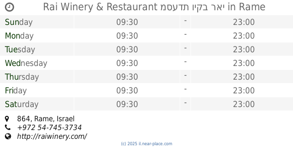
Rai Winery & Restaurant מסעדת ויקב ראי
864, Rame
Restaurant
Bar
Food
Point of interest
Establishment
read more
5.71 km
Meeting Thomas
864, Rameh
Restaurant
read more
5.917 km
מסעדת הגליל בני אבו מאלק חומס פול
דיר חנא
Restaurant
read more
5.917 km
מסעדת הגליל בני אבו מאלק חומס פול
Deir Hanna
Restaurant
read more
5.942 km
שראביכ
Rameh
Restaurant
read more
6.351 km
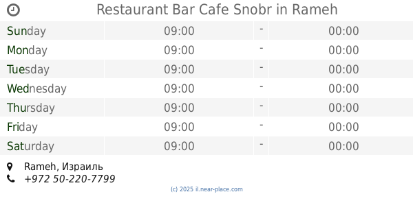
Restaurant Bar Cafe Snobr
Rameh
Restaurant
read more
6.369 km
אבו ראמי - כפר ראמה
ראמה
Restaurant
read more
📑
all categories
Accounting
Administrative area level 1
Administrative area level 2
Airport
Amusement park
Aquarium
Art gallery
Atm
Bakery
Bank
Bar
Beauty salon
Bicycle store
Book store
Bowling alley
Bus station
Cafe
Campground
Car dealer
Car rental
Car repair
Car wash
Casino
Cemetery
Church
City hall
Clothing store
Colloquial area
Convenience store
Country
Courthouse
Dentist
Department store
Doctor
Electrician
Electronics store
Embassy
Establishment
Finance
Fire station
Florist
Food
Funeral home
Furniture store
Gas station
General contractor
Grocery or supermarket
Gym
Hair care
Hardware store
Health
Hindu Temple
Home goods store
Hospital
Insurance agency
Intersection
Jewelry store
Laundry
Lawyer
Library
Light rail station
Liquor store
Local government office
Locality
Locksmith
Lodging
Meal delivery
Meal takeaway
Mosque
Movie rental
Movie theater
Moving company
Museum
Natural feature
Neighborhood
Night club
Painter
Park
Parking
Pet store
Pharmacy
Physiotherapist
Place of worship
Plumber
Point of interest
Police
Political
Post office
Premise
Real estate agency
Restaurant
Roofing contractor
Route
Rv park, camping
School
Shoe store
Shopping mall
Spa
Stadium
Storage
Store
Subpremise
Subway station
Supermarket
Synagogue
Taxi stand
Train station
Transit station
Travel agency
University
Veterinary care
Zoo
administrative area level 3
administrative area level 4
sublocality level 1
↑