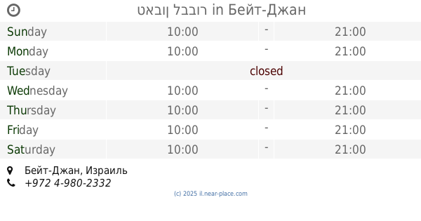
Restaurant nearby חומוס פלאפל אבו רסיל
Israel
Restaurant nearby חומוס פלאפל אבו רסיל
חומוס פלאפל אבו רסיל
Бейт-Джан, Израиль
contacts phone
:
+972 50-446-1118
Latitude:
32.9634285
, Longitude:
35.3808785
larger map & directions
read more
nearest Restaurant
חומוס פלאפל אבו רסיל
בית ג'ן
Restaurant
read more
2 m
מסעדת השף
Beit Jann
Restaurant
read more
2 m
מסעדת השף
בית ג'ן
Restaurant
read more
65 m
אירוח לבבי
Beit Jann
Restaurant
read more
147 m
טורטיבילה
Beit Jann
Restaurant
read more
150 m
שווארמה ופלאפל מאגד
בית ג'ן
Restaurant
read more
197 m
Monroe Cafe
Beit Jann
Restaurant
read more
241 m
החומוסיה
Beit Jann
Restaurant
read more
249 m
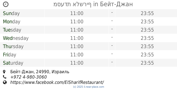
מסעדת אלשריף
Beit Jann
Restaurant
read more
250 m
סאפא חרב
בית ג'ן
Restaurant
read more
250 m
טאבון לבבור
Beit Jann
Restaurant
read more
250 m
Hvaya Ihudit
בית ג'ן
Restaurant
read more
250 m
طابون الببور טאבון אלבבור
בית ג'ן
Restaurant
read more
250 m
طابون الببور טאבון אלבבור
Beit Jann
Restaurant
read more
386 m
לה קוינטה
Beit Jann
Restaurant
read more
546 m
Restaurant Amal Dabur unique experience
Beit Jann
Restaurant
read more
899 m
Sendian Restaurant
בית ג'ן
Restaurant
read more
1.187 km
Har Mar Restaurant
Unnamed Road, Beit Jann
Restaurant
read more
1.922 km
Poppy vineyards foods Fares
Ha-Rama Street, Dimona
Restaurant
read more
2.257 km
מסעדת אלערישה
ראמה
Restaurant
read more
2.257 km
Restaurant El Arish
Rameh
Restaurant
read more
2.258 km
alareesha العريشه אלערישה
כביש ראמה בית ג'ן, Rame
Restaurant
Food
Point of interest
Establishment
read more
2.926 km
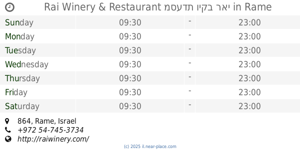
Rai Winery & Restaurant מסעדת ויקב ראי
864, Rame
Restaurant
Bar
Food
Point of interest
Establishment
read more
3.315 km
אבו ראמי - כפר ראמה
ראמה
Restaurant
read more
3.352 km
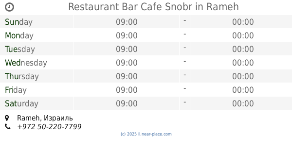
Restaurant Bar Cafe Snobr
Rameh
Restaurant
read more
📑
all categories
Accounting
Administrative area level 1
Administrative area level 2
Airport
Amusement park
Aquarium
Art gallery
Atm
Bakery
Bank
Bar
Beauty salon
Bicycle store
Book store
Bowling alley
Bus station
Cafe
Campground
Car dealer
Car rental
Car repair
Car wash
Casino
Cemetery
Church
City hall
Clothing store
Colloquial area
Convenience store
Country
Courthouse
Dentist
Department store
Doctor
Electrician
Electronics store
Embassy
Establishment
Finance
Fire station
Florist
Food
Funeral home
Furniture store
Gas station
General contractor
Grocery or supermarket
Gym
Hair care
Hardware store
Health
Hindu Temple
Home goods store
Hospital
Insurance agency
Intersection
Jewelry store
Laundry
Lawyer
Library
Light rail station
Liquor store
Local government office
Locality
Locksmith
Lodging
Meal delivery
Meal takeaway
Mosque
Movie rental
Movie theater
Moving company
Museum
Natural feature
Neighborhood
Night club
Painter
Park
Parking
Pet store
Pharmacy
Physiotherapist
Place of worship
Plumber
Point of interest
Police
Political
Post office
Premise
Real estate agency
Restaurant
Roofing contractor
Route
Rv park, camping
School
Shoe store
Shopping mall
Spa
Stadium
Storage
Store
Subpremise
Subway station
Supermarket
Synagogue
Taxi stand
Train station
Transit station
Travel agency
University
Veterinary care
Zoo
administrative area level 3
administrative area level 4
sublocality level 1
↑