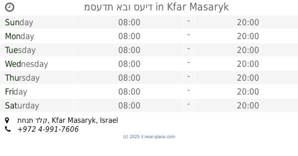
Restaurant nearby חדר אוכל
Israel
Restaurant nearby חדר אוכל
חדר אוכל
Unnamed Road, כפר מסריק ישראל
contacts phone
:
+972
Latitude:
32.8900502
, Longitude:
35.0995367
read more
nearest Restaurant
Dining Room
Unnamed Road, כפר מסריק
Restaurant
read more
226 m
מסעדת אבו סעיד
תחנת דלק, כפר מסריק
Restaurant
read more
226 m
מסעדת אבו סעיד
תחנת דלק, Kfar Masaryk
Restaurant
read more
561 m
מסעדת אבו סעיד
מרכז נעמן כביש עכו חיפה אזו תעשיה עכו ג תחנת דלק סונול, Acre
Restaurant
read more
567 m
מסעדת אהו סעיד
Acre
Restaurant
read more
575 m
Restaurant honey
Acre
Restaurant
read more
575 m
מסעדת אבו סעיד
כפר מסריק
Restaurant
read more
575 m
מסעדת אבו סעיד
Kfar Masaryk
Restaurant
read more
578 m
טאובונבון
עכו
Restaurant
read more
578 m
טאובונבון
Acre
Restaurant
read more
578 m
Nat'ke Burger
Acre
Restaurant
read more
1.181 km
פלאפל תנעמי
Acre
Restaurant
read more
1.181 km
פלאפל תנעמי
עכו
Restaurant
read more
1.25 km
פיצה דבאח
Israel
Restaurant
read more
1.382 km
משאוושה מסעדת חומוס פול
מראה המפרץ, עכו
Restaurant
read more
1.384 km
אולמי ארד
Ein HaMifratz
Restaurant
Food
Point of interest
Establishment
read more
1.392 km
McDonald's
מרכז מסחרי עין המפרץ
Restaurant
Food
Point of interest
Establishment
read more
1.397 km
מסעדה לבנונית
עין המפרץ
Restaurant
read more
1.402 km
פלאפל עווד
עין המפרץ
Restaurant
read more
1.402 km
Falafel Awad فلافل عوض פלאפל עווד
Ein HaMifratz
Restaurant
read more
1.416 km
Lebanony's restaurant
Ein HaMifratz
Restaurant
read more
1.417 km
Lebanese Resturant
Ein HaMifratz
Restaurant
read more
1.482 km
Ocean Secrets
Baltimor Street 13, Acre
Restaurant
read more
2.241 km
בשרים וטעמים
Moshe Boronstein Street 57, Acre
Restaurant
read more
2.241 km
בשרים וטעמים
משה בורונשטיין 57, עכו
Restaurant
read more
📑
all categories
Accounting
Administrative area level 1
Administrative area level 2
Airport
Amusement park
Aquarium
Art gallery
Atm
Bakery
Bank
Bar
Beauty salon
Bicycle store
Book store
Bowling alley
Bus station
Cafe
Campground
Car dealer
Car rental
Car repair
Car wash
Casino
Cemetery
Church
City hall
Clothing store
Colloquial area
Convenience store
Country
Courthouse
Dentist
Department store
Doctor
Electrician
Electronics store
Embassy
Establishment
Finance
Fire station
Florist
Food
Funeral home
Furniture store
Gas station
General contractor
Grocery or supermarket
Gym
Hair care
Hardware store
Health
Hindu Temple
Home goods store
Hospital
Insurance agency
Intersection
Jewelry store
Laundry
Lawyer
Library
Light rail station
Liquor store
Local government office
Locality
Locksmith
Lodging
Meal delivery
Meal takeaway
Mosque
Movie rental
Movie theater
Moving company
Museum
Natural feature
Neighborhood
Night club
Painter
Park
Parking
Pet store
Pharmacy
Physiotherapist
Place of worship
Plumber
Point of interest
Police
Political
Post office
Premise
Real estate agency
Restaurant
Roofing contractor
Route
Rv park, camping
School
Shoe store
Shopping mall
Spa
Stadium
Storage
Store
Subpremise
Subway station
Supermarket
Synagogue
Taxi stand
Train station
Transit station
Travel agency
University
Veterinary care
Zoo
administrative area level 3
administrative area level 4
sublocality level 1
↑