Restaurant nearby ג'וני קריספי
Israel
Restaurant nearby ג'וני קריספי
ג'וני קריספי
43, Sderot Giborei Israel, Netanya, HaSharon, IL Israel
contacts phone
:
+972 9-955-9090
website:
www.johnnycrispy.com
Latitude:
32.2833246
, Longitude:
34.8617029
larger map & directions
read more
nearest Restaurant
ג'וני קריספי
שדרות גיבורי ישראל 43, נתניה
Restaurant
read more
193 m
הבית המרוקאי
גד מנלה 1, נתניה
Restaurant
read more
233 m
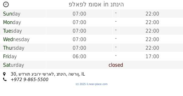
פלאפל מוסא
שדרות גיבורי ישראל 30, נתניה
Restaurant
read more
237 m
Рубинштейн
גיבורי ישראל 17, נתניה
Restaurant
read more
250 m
מוזס נתניה
Sderot Giborei Israel 17, Netanya
Restaurant
read more
257 m
בלאק
מרכז אלכסנדרה יכין, גיבורי ישראל 17, נתניה
Restaurant
read more
342 m
Royal
Ha-Bonim Street 18, Netanya
Restaurant
read more
365 m
מזנון בחניון
Unnamed Road, נתניה
Restaurant
read more
570 m
מסעדת רימונים
המחשב 1, נתניה
Restaurant
read more
575 m
Kitchen Bar
גיבורי ישראל 7, Netanya
Restaurant
read more
722 m
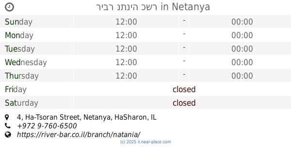
ריבר נתניה כשר
Ha-Tsoran Street 4, Netanya
Restaurant
read more
726 m
Ресторан Колизей
הצורן 4, נתניה
Restaurant
read more
774 m
יוספון - מסעדה בשרית וטבעונית
הצורן 4, נתניה
Restaurant
read more
811 m
Suduch
Sderot Giborei Israel 5, Netanya
Restaurant
read more
852 m
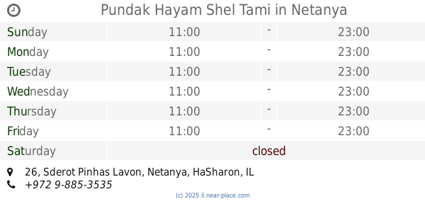
Pundak Hayam Shel Tami
Sderot Pinhas Lavon 26, Netanya
Restaurant
read more
852 m
Pundak Hayam Shel Tami
שדרות פנחס לבון 26, נתניה
Restaurant
read more
879 m
Kampai street wok
סינמה סיטי, המחקר 3, נתניה
Restaurant
read more
903 m
Segev Concept
HaMehkar Street 3, Netanya
Restaurant
read more
920 m
Fantasia
סינמה סיטי, המחקר 3, נתניה
Restaurant
read more
935 m
Fantasia
סינמה סיטי, HaMehkar Street 3, Netanya
Restaurant
read more
944 m
Bleecker
Netanya
Restaurant
read more
948 m
ביגה - BIGA - מטבח בייקרי קפה
Netanya
Restaurant
read more
953 m
פיאנו פיאנו
המחקר 2, נתניה
Restaurant
read more
960 m
נגיסה
Maffi Street 5, Netanya
Restaurant
read more
1.253 km
פיצה Katorza
Agam Kinneret Street 6, Netanya
Restaurant
read more
📑
all categories
Accounting
Administrative area level 1
Administrative area level 2
Airport
Amusement park
Aquarium
Art gallery
Atm
Bakery
Bank
Bar
Beauty salon
Bicycle store
Book store
Bowling alley
Bus station
Cafe
Campground
Car dealer
Car rental
Car repair
Car wash
Casino
Cemetery
Church
City hall
Clothing store
Colloquial area
Convenience store
Country
Courthouse
Dentist
Department store
Doctor
Electrician
Electronics store
Embassy
Establishment
Finance
Fire station
Florist
Food
Funeral home
Furniture store
Gas station
General contractor
Grocery or supermarket
Gym
Hair care
Hardware store
Health
Hindu Temple
Home goods store
Hospital
Insurance agency
Intersection
Jewelry store
Laundry
Lawyer
Library
Light rail station
Liquor store
Local government office
Locality
Locksmith
Lodging
Meal delivery
Meal takeaway
Mosque
Movie rental
Movie theater
Moving company
Museum
Natural feature
Neighborhood
Night club
Painter
Park
Parking
Pet store
Pharmacy
Physiotherapist
Place of worship
Plumber
Point of interest
Police
Political
Post office
Premise
Real estate agency
Restaurant
Roofing contractor
Route
Rv park, camping
School
Shoe store
Shopping mall
Spa
Stadium
Storage
Store
Subpremise
Subway station
Supermarket
Synagogue
Taxi stand
Train station
Transit station
Travel agency
University
Veterinary care
Zoo
administrative area level 3
administrative area level 4
sublocality level 1
↑