Restaurant nearby ג'חנון לולו
Israel
Restaurant nearby ג'חנון לולו
ג'חנון לולו
זיקים, ישראל
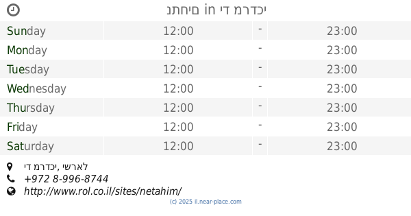
contacts phone
:
+972 55-977-7429
Latitude:
31.6072419
, Longitude:
34.5213456
larger map & directions
read more
nearest Restaurant
748 m
גחנוןלולו
צומת, Zikim
Restaurant
read more
4.432 km
Humus Eliyahu
Sderot Hayim Barlev 28, Ashkelon
Restaurant
read more
4.432 km
חומוס אליהו אשקלון
Sderot Hayim Barlev 28, Ashkelon
Restaurant
read more
4.496 km
נתחים
יד מרדכי
Restaurant
read more
4.496 km
נתחים
יד מרדכי, Yad Mordechai
Restaurant
read more
4.501 km
קריספי
Hutsot HaYotser Street 2, Ashkelon
Restaurant
read more
4.501 km
קריספי
חוצות היוצר 2, אשקלון
Restaurant
read more
4.502 km
בוצ'רס
הנשיא 4, אשקלון
Restaurant
read more
4.502 km
בוצ'רס
Ha-Nasi Street 4, Ashkelon
Restaurant
read more
4.504 km
סטודיו קריספי
Hutsot HaYotser Street 2, Ashkelon
Restaurant
read more
4.517 km
Simpatya
1 Hutzot Hayotzer St, Ashkelon
Restaurant
read more
4.517 km
מסעדת סימפטיה
1 Hutzot Hayotzer St, Ashkelon
Restaurant
read more
4.594 km
Jewelry - Kibbutz Yad Mordechai
Israel
Restaurant
read more
4.622 km
החומוסיה
צומת יד מרדכי
Restaurant
read more
6.639 km
استراحة و كفتريا المرسى
بيت غانم, Nagaa Al Dear Al Abied Al Bahri - Nagaa Hamed
Restaurant
read more
7.458 km
Freddies
Ashkelon
Restaurant
read more
7.517 km
Chiang Mai
Sderot David Ben Gurion 21, Ashkelon
Restaurant
read more
8.068 km
אנמארו
Gia
Restaurant
read more
8.521 km
פוראמה בעמ
Ort Street 26, Ashkelon
Restaurant
Food
Point of interest
Establishment
read more
8.541 km
פוראמה
אורט 26, אשקלון
Restaurant
read more
8.789 km
Mai Way Asian restaurant
Tsfanya Street 10, Ashkelon
Restaurant
Food
Point of interest
Establishment
read more
8.821 km
בינג'מין טפאס בר
הנמל 7, אשקלון
Restaurant
read more
9.078 km
Top Burger
Tsahal Street 23, Ashkelon
Restaurant
read more
12.642 km
Level Up Restaurant
El-Zomor Canal
Restaurant
read more
14.627 km
مطعم اسطنبول
الشيخ عجلين
Restaurant
read more
📑
all categories
Accounting
Administrative area level 1
Administrative area level 2
Airport
Amusement park
Aquarium
Art gallery
Atm
Bakery
Bank
Bar
Beauty salon
Bicycle store
Book store
Bowling alley
Bus station
Cafe
Campground
Car dealer
Car rental
Car repair
Car wash
Casino
Cemetery
Church
City hall
Clothing store
Colloquial area
Convenience store
Country
Courthouse
Dentist
Department store
Doctor
Electrician
Electronics store
Embassy
Establishment
Finance
Fire station
Florist
Food
Funeral home
Furniture store
Gas station
General contractor
Grocery or supermarket
Gym
Hair care
Hardware store
Health
Hindu Temple
Home goods store
Hospital
Insurance agency
Intersection
Jewelry store
Laundry
Lawyer
Library
Light rail station
Liquor store
Local government office
Locality
Locksmith
Lodging
Meal delivery
Meal takeaway
Mosque
Movie rental
Movie theater
Moving company
Museum
Natural feature
Neighborhood
Night club
Painter
Park
Parking
Pet store
Pharmacy
Physiotherapist
Place of worship
Plumber
Point of interest
Police
Political
Post office
Premise
Real estate agency
Restaurant
Roofing contractor
Route
Rv park, camping
School
Shoe store
Shopping mall
Spa
Stadium
Storage
Store
Subpremise
Subway station
Supermarket
Synagogue
Taxi stand
Train station
Transit station
Travel agency
University
Veterinary care
Zoo
administrative area level 3
administrative area level 4
sublocality level 1
↑