Restaurant nearby Falafel Orda
Israel
Restaurant nearby Falafel Orda
Falafel Orda
46, Bialik Street, Ramat Gan, IL Израиль
contacts phone
:
+972 3-672-4087
Latitude:
32.0838327
, Longitude:
34.8144035
larger map & directions
read more
nearest Restaurant
362 m
פאלפלנד
ביאליק 77, רמת גן
Restaurant
read more
422 m
סושיאמי
Ze'ev Jabotinsky Street 75, Ramat Gan
Restaurant
read more
514 m
המקסיקנית
Arlozorov Street 2, Ramat Gan
Restaurant
read more
564 m
Rakefet
Ze'ev Jabotinsky Street 99, Ramat Gan
Restaurant
read more
565 m
אגסי
רח' זאב ז'בוטינסקי 99, רמת גן
Restaurant
read more
637 m
פיצה רומא רמת גן
דרך בן גוריון 112, רמת גן
Restaurant
read more
728 m
דדה גבעתיים
כצנלסון 113, גבעתיים
Restaurant
read more
759 m
קבסה גריל
רח' זאב ז'בוטינסקי 35, רמת גן
Restaurant
read more
768 m
The Queen
כצנלסון 109, גבעתיים
Restaurant
read more
770 m
הסביח של עובד
סירקין 7, גבעתיים
Restaurant
read more
784 m
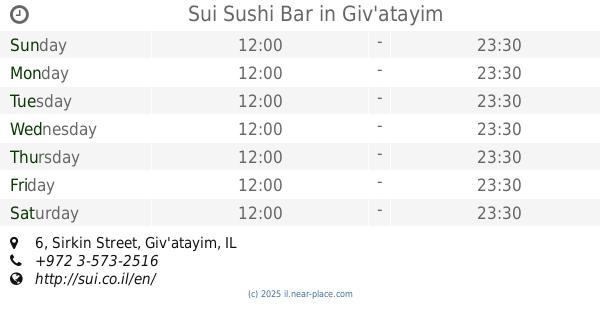
Sui Sushi Bar
Sirkin Street 6, Giv'atayim
Restaurant
read more
838 m
בורגר R
Arlozorov Street 73, Ramat Gan
Restaurant
read more
904 m
חומוס רחוב רמת גן
ארלוזורוב 81, רמת גן
Restaurant
read more
962 m
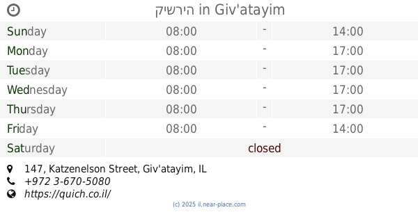
קישריה
Katzenelson Street 147, Giv'atayim
Cafe
Restaurant
Food
Point of interest
Store
Establishment
read more
981 m
אצל באבא סולימן
כצנלסון 149-153, גבעתיים
Restaurant
read more
995 m
מדיום רייר
החילזון 5, רמת גן
Restaurant
read more
1.007 km
שיפודי סמי ובניו
דרך בן גוריון 173, רמת גן
Restaurant
read more
1.011 km
Эль Гаучо
ז’בוטינסקי 134, רמת גן
Restaurant
read more
1.065 km
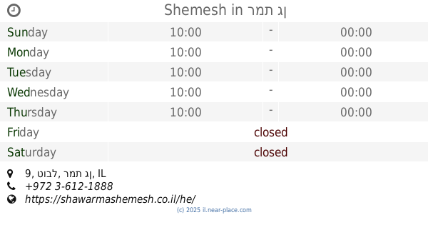
Shemesh
טובל 9, רמת גן
Restaurant
read more
1.068 km
סושימן
Ha-Khilazon Street 1, Ramat Gan
Restaurant
read more
1.079 km
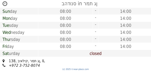
בהדונס
ביאליק 138, רמת גן
Restaurant
read more
1.089 km
Agvania Pizza
Ze'ev Jabotinsky Road 155, Ramat Gan
Restaurant
read more
1.109 km
Anati Bistro Bar
Katzenelson Street 63, Giv'atayim
Restaurant
read more
1.172 km
מאכלים של אמא
דרך בן גוריון 34, רמת גן
Restaurant
read more
1.25 km
טוסט נקניק
Ze'ev Jabotinsky Street 12, Bnei Brak
Restaurant
read more
📑
all categories
Accounting
Administrative area level 1
Administrative area level 2
Airport
Amusement park
Aquarium
Art gallery
Atm
Bakery
Bank
Bar
Beauty salon
Bicycle store
Book store
Bowling alley
Bus station
Cafe
Campground
Car dealer
Car rental
Car repair
Car wash
Casino
Cemetery
Church
City hall
Clothing store
Colloquial area
Convenience store
Country
Courthouse
Dentist
Department store
Doctor
Electrician
Electronics store
Embassy
Establishment
Finance
Fire station
Florist
Food
Funeral home
Furniture store
Gas station
General contractor
Grocery or supermarket
Gym
Hair care
Hardware store
Health
Hindu Temple
Home goods store
Hospital
Insurance agency
Intersection
Jewelry store
Laundry
Lawyer
Library
Light rail station
Liquor store
Local government office
Locality
Locksmith
Lodging
Meal delivery
Meal takeaway
Mosque
Movie rental
Movie theater
Moving company
Museum
Natural feature
Neighborhood
Night club
Painter
Park
Parking
Pet store
Pharmacy
Physiotherapist
Place of worship
Plumber
Point of interest
Police
Political
Post office
Premise
Real estate agency
Restaurant
Roofing contractor
Route
Rv park, camping
School
Shoe store
Shopping mall
Spa
Stadium
Storage
Store
Subpremise
Subway station
Supermarket
Synagogue
Taxi stand
Train station
Transit station
Travel agency
University
Veterinary care
Zoo
administrative area level 3
administrative area level 4
sublocality level 1
↑