Restaurant nearby Diner
Israel
Restaurant nearby Diner
Diner
105, HaHagana Ave, Haifa, Haifa, IL Израиль
contacts phone
:
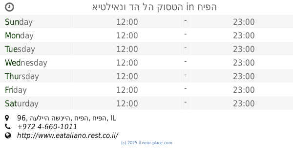
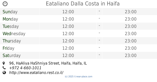
+972 4-851-7459
Latitude:
32.8294349
, Longitude:
34.9639985
larger map & directions
read more
nearest Restaurant
2 m
שרימפס האוס
שדרות ההגנה 105, חיפה
Restaurant
read more
572 m
ברביקיו פוקאצ'ה
Cable Rail, Stela Maris, Haifa
Restaurant
read more
579 m
גולדן קורל
דרך סטלה מריס 100, חיפה
Restaurant
read more
583 m
Monte Carmelo
חיפה
Restaurant
read more
642 m
מסעדת שוואטינא - בת גלים
HaAliya HaShniya Street 96, Haifa
Restaurant
read more
644 m
איטליאנו דה לה קוסטה
העלייה השנייה 96, חיפה
Restaurant
read more
644 m
Eataliano Dalla Costa
HaAliya HaShniya Street 96, Haifa
Restaurant
read more
646 m
Shawatina By The Beach
Haifa
Restaurant
read more
759 m
מסעדת שוואטינא - בת גלים
HaAliya HaShniya Street, Haifa
Restaurant
read more
815 m
אולם אירועים אורות המושבה
טשרניחובסקי 69, חיפה
Restaurant
read more
815 m
Ballroom colony lights
Tchernikhovski Street 69, Haifa
Restaurant
read more
821 m
מזנון ורדי
Tchernikhovski Street 69, Haifa
Restaurant
read more
821 m
מזנון ורדי
טשרניחובסקי 69, חיפה
Restaurant
read more
871 m
דודא
דרך צרפת 63, חיפה
Restaurant
read more
871 m
דודא
Tzorfat Road 63, Haifa
Restaurant
read more
877 m
פיצה שמש
דרך צרפת 63, חיפה
Restaurant
read more
877 m
Shemesh Pizza
Tzorfat Road 63, Haifa
Restaurant
read more
971 m
Shish Kabab
Sderot Ben Gurion 59, Haifa
Restaurant
read more
971 m
Mishel
Ma'ale ha-Wadi St 21, Haifa
Restaurant
read more
971 m
פלאפל מישל
מעלה הואדי 21, חיפה
Restaurant
read more
971 m
Aroma Pizza
Haifa
Restaurant
read more
971 m
פיצה ארומה
חיפה
Restaurant
read more
971 m
Flori
Haifa
Restaurant
read more
971 m
Frangelico
Haifa
Restaurant
read more
971 m
פרנג'ליקו
חיפה
Restaurant
read more
📑
all categories
Accounting
Administrative area level 1
Administrative area level 2
Airport
Amusement park
Aquarium
Art gallery
Atm
Bakery
Bank
Bar
Beauty salon
Bicycle store
Book store
Bowling alley
Bus station
Cafe
Campground
Car dealer
Car rental
Car repair
Car wash
Casino
Cemetery
Church
City hall
Clothing store
Colloquial area
Convenience store
Country
Courthouse
Dentist
Department store
Doctor
Electrician
Electronics store
Embassy
Establishment
Finance
Fire station
Florist
Food
Funeral home
Furniture store
Gas station
General contractor
Grocery or supermarket
Gym
Hair care
Hardware store
Health
Hindu Temple
Home goods store
Hospital
Insurance agency
Intersection
Jewelry store
Laundry
Lawyer
Library
Light rail station
Liquor store
Local government office
Locality
Locksmith
Lodging
Meal delivery
Meal takeaway
Mosque
Movie rental
Movie theater
Moving company
Museum
Natural feature
Neighborhood
Night club
Painter
Park
Parking
Pet store
Pharmacy
Physiotherapist
Place of worship
Plumber
Point of interest
Police
Political
Post office
Premise
Real estate agency
Restaurant
Roofing contractor
Route
Rv park, camping
School
Shoe store
Shopping mall
Spa
Stadium
Storage
Store
Subpremise
Subway station
Supermarket
Synagogue
Taxi stand
Train station
Transit station
Travel agency
University
Veterinary care
Zoo
administrative area level 3
administrative area level 4
sublocality level 1
↑