Restaurant nearby Calma
Coronavirus disease (COVID-19) Situation
confirmed cases
4841772
deaths
12707
Israel
Restaurant nearby Calma
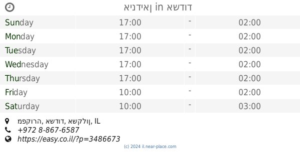
Calma
1, הטיילת, אשדוד, אשקלון, IL Izrael
contacts phone
:
+972 8-866-7241
website:
calma.rest.co.il
Latitude:
31.8071327
, Longitude:
34.6366344
larger map & directions
read more
nearest Restaurant
188 m
Legal Bar Restaurant
HaTayelet 1, Ashdod
Restaurant
read more
369 m
מסעדת אנדיב Endive
הטיילת 21, אשדוד
Restaurant
read more
464 m
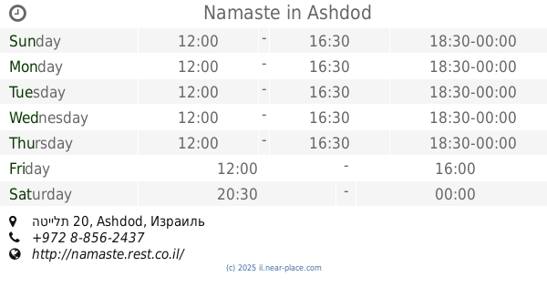
Namaste
הטיילת 20, Ashdod
Restaurant
read more
494 m
חצר אחורית
האשל 7, אשדוד
Restaurant
read more
583 m
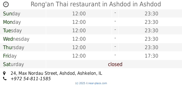
רונג׳אן מסעדה תאילנדית אשדוד
24, מקס נורדאו, אשדוד
Restaurant
read more
602 m
Rong'an Thai restaurant in Ashdod
Max Nordau Street 24, Ashdod
Restaurant
read more
671 m
שניצלוס
רוגוזין 11, אשדוד
Restaurant
read more
673 m
La Brioche
Rogozin Street 27, Ashdod
Restaurant
read more
720 m
restaurant Pataya beach
Martin Buber Street 1, Ashdod
Restaurant
read more
771 m
Pescado
Martin Buber Street 1, Ashdod
Restaurant
read more
772 m
הולנד צ'יפס
Rogozin Street 72, Ashdod
Restaurant
read more
782 m
טו גייז
Shavei Tsiyon Street 2, Ashdod
Restaurant
read more
813 m
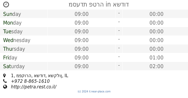
מסעדת פטרה
מפקורה 1, אשדוד
Restaurant
read more
818 m
קונקורד
מפקורה, אשדוד
Restaurant
read more
821 m
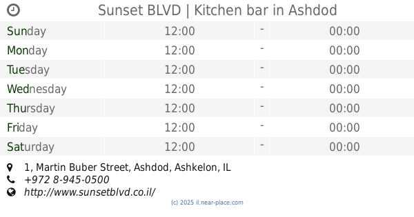
Sunset BLVD | Kitchen bar
Martin Buber Street 1, Ashdod
Bar
Restaurant
Food
Point of interest
Establishment
read more
831 m
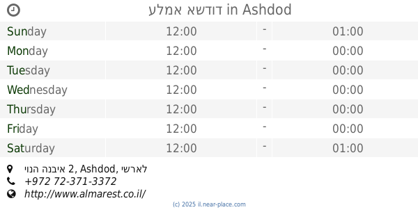
עלמא אשדוד
יונה הנביא 2, Ashdod
Restaurant
read more
875 m
פורטו
סמטת אל הים 2, אשדוד
Restaurant
read more
880 m
השווארמה של אילן
Ashdod
Restaurant
read more
880 m
השווארמה של אילן
אשדוד
Restaurant
read more
891 m
Sapanlove
סמטת אל הים, אשדוד
Restaurant
read more
911 m
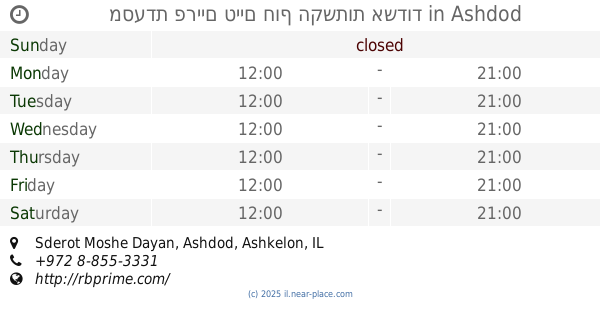
מסעדת פריים טיים חוף הקשתות אשדוד
Sderot Moshe Dayan, Ashdod
Restaurant
Food
Point of interest
Establishment
read more
914 m
אינדיאן
מפקורה, אשדוד
Restaurant
read more
914 m
אינדיאן
Mafkura Street, Ashdod
Restaurant
read more
928 m
פיצה לידו
שבי ציון 10, אשדוד
Restaurant
read more
1.138 km
Kira
Yair Street 4, Ashdod
Restaurant
read more
📑
all categories
Accounting
Administrative area level 1
Administrative area level 2
Airport
Amusement park
Aquarium
Art gallery
Atm
Bakery
Bank
Bar
Beauty salon
Bicycle store
Book store
Bowling alley
Bus station
Cafe
Campground
Car dealer
Car rental
Car repair
Car wash
Casino
Cemetery
Church
City hall
Clothing store
Colloquial area
Convenience store
Country
Courthouse
Dentist
Department store
Doctor
Electrician
Electronics store
Embassy
Establishment
Finance
Fire station
Florist
Food
Funeral home
Furniture store
Gas station
General contractor
Grocery or supermarket
Gym
Hair care
Hardware store
Health
Hindu Temple
Home goods store
Hospital
Insurance agency
Intersection
Jewelry store
Laundry
Lawyer
Library
Light rail station
Liquor store
Local government office
Locality
Locksmith
Lodging
Meal delivery
Meal takeaway
Mosque
Movie rental
Movie theater
Moving company
Museum
Natural feature
Neighborhood
Night club
Painter
Park
Parking
Pet store
Pharmacy
Physiotherapist
Place of worship
Plumber
Point of interest
Police
Political
Post office
Premise
Real estate agency
Restaurant
Roofing contractor
Route
Rv park, camping
School
Shoe store
Shopping mall
Spa
Stadium
Storage
Store
Subpremise
Subway station
Supermarket
Synagogue
Taxi stand
Train station
Transit station
Travel agency
University
Veterinary care
Zoo
administrative area level 3
administrative area level 4
sublocality level 1
↑