Restaurant nearby Burger King
Israel
Restaurant nearby Burger King
Burger King
3, ז'בוטינסקי, הוד השרון, פתח תקווה, IL ישראל
contacts phone
:
+972
Latitude:
32.1434231
, Longitude:
34.8914965
larger map & directions
read more
nearest Restaurant
9 m
איש' איש'
Jabotinski Street 3, Hod Hasharon
Restaurant
read more
15 m
Oshi Oshi
Jabotinski Street 3, Hod Hasharon
Restaurant
read more
44 m
Asia Monica
Jabotinski Street, Hod Hasharon
Restaurant
read more
283 m
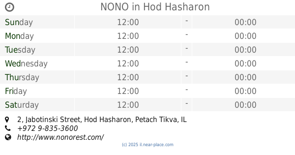
NONO
Jabotinski Street 2, Hod Hasharon
Restaurant
read more
465 m
נגיסה סושי בר
תש"ח 13, תל אביב יפו
Restaurant
read more
465 m
נגיסה סושי בר
Tashah Street 13, Tel Aviv-Yafo
Restaurant
read more
634 m
הדרבי וילה
הציונות 7, הוד השרון
Restaurant
read more
634 m
הדרבי וילה
Ha-Tsiyonut Street 7, Hod Hasharon
Restaurant
read more
651 m
דרבי הוילה
הציונות, הוד השרון
Restaurant
read more
651 m
דרבי הוילה
Ha-Tsiyonut Street, Hod Hasharon
Restaurant
read more
729 m
עץ הלימון
החשמונאים 2, הוד השרון
Restaurant
read more
729 m
עץ הלימון
Ha-Khashmona'im Street 2, Hod Hasharon
Restaurant
read more
1.313 km
טאקוס טורטיה בר
דרך רמתיים 69, הוד השרון
Restaurant
read more
1.33 km
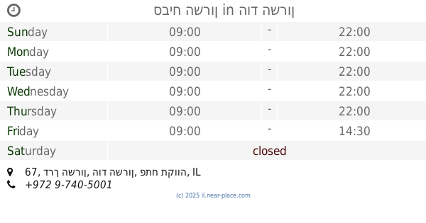
סביח השרון
דרך השרון 67, הוד השרון
Restaurant
read more
1.343 km
הטאבון
דרך רמתיים 90, הוד השרון
Restaurant
read more
1.359 km
בורקס באבא
Ramatayim Road 88, Hod Hasharon
Restaurant
read more
1.395 km
התרנגול - גריל בשרים ישראלי
Ramatayim Road 65, Hod Hasharon
Restaurant
read more
1.405 km
סנדוויץ אקספרס
Derech HaMaccabim 54, Rishon LeTsiyon
Restaurant
Food
Point of interest
Establishment
read more
1.409 km
המחבוא
HaBanim Street 12, Hod Hasharon
Restaurant
read more
1.45 km
Al MIzan Tower
Al Howra'a Street, Riyadh
Restaurant
read more
1.592 km
Agadir Hod Hasharon
Ramatayim Road 51, Hod Hasharon
Restaurant
read more
1.605 km
מסעדת BBB
הוד השרון
Restaurant
read more
1.979 km
Pasta Mia
רמתיים 21, הוד השרון
Restaurant
read more
2.19 km
מסעדה ברבאטוב
הידידות 9, כיכר מגדיאל, Hod Hasharon
Restaurant
read more
2.427 km
חמש
HaEkaliptus Street 33, Ramot HaShavim
Restaurant
read more
📑
all categories
Accounting
Administrative area level 1
Administrative area level 2
Airport
Amusement park
Aquarium
Art gallery
Atm
Bakery
Bank
Bar
Beauty salon
Bicycle store
Book store
Bowling alley
Bus station
Cafe
Campground
Car dealer
Car rental
Car repair
Car wash
Casino
Cemetery
Church
City hall
Clothing store
Colloquial area
Convenience store
Country
Courthouse
Dentist
Department store
Doctor
Electrician
Electronics store
Embassy
Establishment
Finance
Fire station
Florist
Food
Funeral home
Furniture store
Gas station
General contractor
Grocery or supermarket
Gym
Hair care
Hardware store
Health
Hindu Temple
Home goods store
Hospital
Insurance agency
Intersection
Jewelry store
Laundry
Lawyer
Library
Light rail station
Liquor store
Local government office
Locality
Locksmith
Lodging
Meal delivery
Meal takeaway
Mosque
Movie rental
Movie theater
Moving company
Museum
Natural feature
Neighborhood
Night club
Painter
Park
Parking
Pet store
Pharmacy
Physiotherapist
Place of worship
Plumber
Point of interest
Police
Political
Post office
Premise
Real estate agency
Restaurant
Roofing contractor
Route
Rv park, camping
School
Shoe store
Shopping mall
Spa
Stadium
Storage
Store
Subpremise
Subway station
Supermarket
Synagogue
Taxi stand
Train station
Transit station
Travel agency
University
Veterinary care
Zoo
administrative area level 3
administrative area level 4
sublocality level 1
↑