Restaurant nearby Brown
Israel
Restaurant nearby Brown
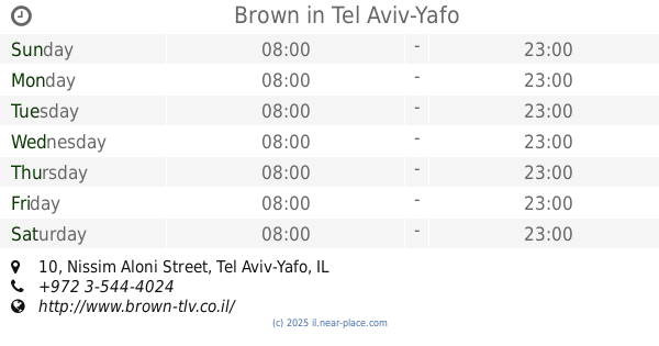
Brown
10, ניסים אלוני, תל אביב יפו, IL ישראל
contacts phone
:
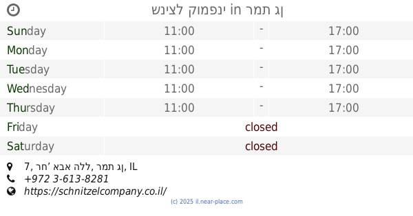
+972 3-544-4024
website:
www.brown-tlv.co.il
Latitude:
32.0887427
, Longitude:
34.7971861
larger map & directions
read more
nearest Restaurant
Brown
Nissim Aloni Street 10, Tel Aviv-Yafo
Restaurant
read more
7 m
מר וגברת לי
ניסים אלוני 10, תל אביב יפו
Restaurant
read more
469 m
סלט בר קיוסק קפה
Derech Menachem Begin 20, Ramat Gan
Restaurant
read more
498 m
Kaspi
Tel Aviv-Yafo
Restaurant
read more
503 m
Bishulim Bameromim
Ha-Yetsira Street 25, Ramat Gan
Restaurant
read more
535 m
בגחלים
שהם 1, רמת גן
Restaurant
read more
580 m
ממטבחה של רות סירקיס
Bialik Street 131, Ramat Gan
Restaurant
read more
595 m
NOON
תובל 30, רמת גן
Restaurant
read more
599 m
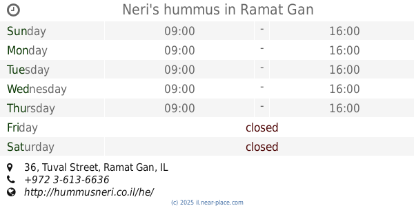
Neri's hummus
Tuval Street 36, Ramat Gan
Restaurant
read more
612 m
ביסטרו דומיניק בע"מ
Tuval Street 22, Ramat Gan
Restaurant
read more
646 m
שניצל ליין
החילזון 2, רמת גן
Restaurant
read more
646 m
שניצל ליין
Ha-Khilazon Street 2, Ramat Gan
Restaurant
read more
647 m
סושימן
Ha-Khilazon Street 1, Ramat Gan
Restaurant
read more
652 m
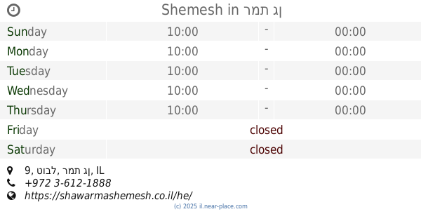
Shemesh
טובל 9, רמת גן
Restaurant
read more
680 m
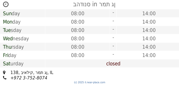
בהדונס
ביאליק 138, רמת גן
Restaurant
read more
711 m
סילבר
Abba Hillel Silver Road 7, Ramat Gan
Restaurant
read more
716 m
Shnitzel Company
רח’ אבא הלל 7, רמת גן
Restaurant
read more
716 m
שניצל קומפני
רח’ אבא הלל 7, רמת גן
Restaurant
read more
718 m
מדיום רייר
החילזון 5, רמת גן
Restaurant
read more
790 m
Mana Mana
Yehuda HaMaccabi Street 65, Tel Aviv-Yafo
Restaurant
read more
844 m
חומוסיית חמסה חמסה
דרך אבא הלל 2, רמת גן
Restaurant
read more
844 m
Hamsa Hamsa Hummus
Abba Hillel Silver Road 2, Ramat Gan
Restaurant
read more
1.047 km
Чука
Weizmann Street 14, Tel Aviv-Yafo
Restaurant
read more
1.067 km
חומוס רחוב רמת גן
ארלוזורוב 81, רמת גן
Restaurant
read more
1.082 km
Al Dente
Weizmann Street 14, Tel Aviv-Yafo
Restaurant
read more
📑
all categories
Accounting
Administrative area level 1
Administrative area level 2
Airport
Amusement park
Aquarium
Art gallery
Atm
Bakery
Bank
Bar
Beauty salon
Bicycle store
Book store
Bowling alley
Bus station
Cafe
Campground
Car dealer
Car rental
Car repair
Car wash
Casino
Cemetery
Church
City hall
Clothing store
Colloquial area
Convenience store
Country
Courthouse
Dentist
Department store
Doctor
Electrician
Electronics store
Embassy
Establishment
Finance
Fire station
Florist
Food
Funeral home
Furniture store
Gas station
General contractor
Grocery or supermarket
Gym
Hair care
Hardware store
Health
Hindu Temple
Home goods store
Hospital
Insurance agency
Intersection
Jewelry store
Laundry
Lawyer
Library
Light rail station
Liquor store
Local government office
Locality
Locksmith
Lodging
Meal delivery
Meal takeaway
Mosque
Movie rental
Movie theater
Moving company
Museum
Natural feature
Neighborhood
Night club
Painter
Park
Parking
Pet store
Pharmacy
Physiotherapist
Place of worship
Plumber
Point of interest
Police
Political
Post office
Premise
Real estate agency
Restaurant
Roofing contractor
Route
Rv park, camping
School
Shoe store
Shopping mall
Spa
Stadium
Storage
Store
Subpremise
Subway station
Supermarket
Synagogue
Taxi stand
Train station
Transit station
Travel agency
University
Veterinary care
Zoo
administrative area level 3
administrative area level 4
sublocality level 1
↑