Restaurant nearby בגט שאולי
Israel
Restaurant nearby בגט שאולי
בגט שאולי
יוקנעם עילית, ישראל
contacts phone
:
+972 50-938-9387
Latitude:
32.6634614
, Longitude:
35.1050735
larger map & directions
read more
nearest Restaurant
4 m
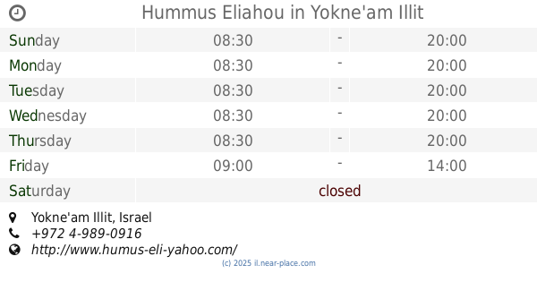
Hummus Eliahou
Yokne'am Illit
Restaurant
read more
43 m
שווארמה, חומוס, סנדוויץ
יוקנעם עילית
Restaurant
read more
174 m
אחוזת סימיטה
המלאכה, יוקנעם עילית
Restaurant
read more
238 m
בוניטו
התעשייה 2, יוקנעם עילית
Restaurant
read more
269 m
Burgerim
HaMelacha Street 1, Yokne'am Illit
Restaurant
read more
278 m
Hameah H-21
1 Hatamar St, Yokne'am Elit
Restaurant
read more
333 m
חי בכיכר
HaKidma Street 17, Yokne'am Illit
Restaurant
read more
382 m
מקדונלד'ס - יקנעם
התמר 2, יוקנעם עילית
Restaurant
read more
385 m
Buddha Burgers
Ha-Tamar Street 2, Yokne'am Illit
Restaurant
read more
385 m
Buddha Burgers
התמר 2, יוקנעם עילית
Restaurant
read more
403 m
הסושיה
Ha-Tamar St 2 Yokne'am Illit, 2061502, Ha-Tamar Street 2, Yokne'am Illit
Restaurant
read more
415 m
בורגוס בורגר בר
מתחם G, התמר 2, יוקנעם עילית
Restaurant
read more
428 m
חומוס בסבוסה
התמר 2, יוקנעם עילית
Restaurant
read more
464 m
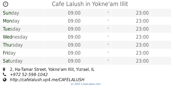
Cafe Lalush
Ha-Tamar Street 2, Yokne'am Illit
Restaurant
read more
474 m
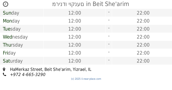
מרינדו
G, המרכז, בית שערים
Restaurant
read more
474 m
מרינדו יוקנעם
G, HaMerkaz Street, Beit She'arim
Restaurant
read more
474 m
מרינדו יוקנעם
G, המרכז, בית שערים
Restaurant
read more
601 m
פלאפל שאבי
יוקנעם עילית
Restaurant
read more
601 m
פלאפל שאבי
Yokne'am Illit
Restaurant
read more
707 m
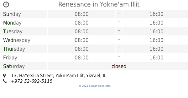
Renesance
היצירה 13, יוקנעם עילית
Restaurant
read more
707 m
Renesance
HaYetsira Street 13, Yokne'am Illit
Restaurant
read more
866 m
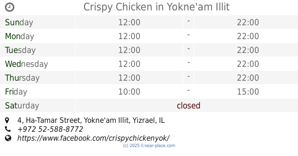
Crispy Chicken
Ha-Tamar Street 4, Yokne'am Illit
Restaurant
read more
866 m
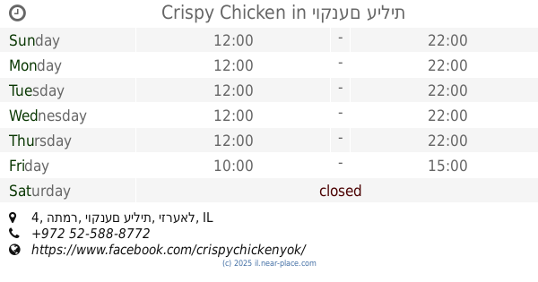
Crispy Chicken
התמר 4, יוקנעם עילית
Restaurant
read more
943 m
לאנץ׳ בורגר
התמר 4, יוקנעם עילית
Restaurant
read more
1.055 km
פנינת יקנעם
Yokne'am Illit
Restaurant
read more
📑
all categories
Accounting
Administrative area level 1
Administrative area level 2
Airport
Amusement park
Aquarium
Art gallery
Atm
Bakery
Bank
Bar
Beauty salon
Bicycle store
Book store
Bowling alley
Bus station
Cafe
Campground
Car dealer
Car rental
Car repair
Car wash
Casino
Cemetery
Church
City hall
Clothing store
Colloquial area
Convenience store
Country
Courthouse
Dentist
Department store
Doctor
Electrician
Electronics store
Embassy
Establishment
Finance
Fire station
Florist
Food
Funeral home
Furniture store
Gas station
General contractor
Grocery or supermarket
Gym
Hair care
Hardware store
Health
Hindu Temple
Home goods store
Hospital
Insurance agency
Intersection
Jewelry store
Laundry
Lawyer
Library
Light rail station
Liquor store
Local government office
Locality
Locksmith
Lodging
Meal delivery
Meal takeaway
Mosque
Movie rental
Movie theater
Moving company
Museum
Natural feature
Neighborhood
Night club
Painter
Park
Parking
Pet store
Pharmacy
Physiotherapist
Place of worship
Plumber
Point of interest
Police
Political
Post office
Premise
Real estate agency
Restaurant
Roofing contractor
Route
Rv park, camping
School
Shoe store
Shopping mall
Spa
Stadium
Storage
Store
Subpremise
Subway station
Supermarket
Synagogue
Taxi stand
Train station
Transit station
Travel agency
University
Veterinary care
Zoo
administrative area level 3
administrative area level 4
sublocality level 1
↑