Restaurant nearby Ангус
Israel
Restaurant nearby Ангус
Ангус
20, HaArba'a Street, Tel Aviv-Yafo, IL Израиль
contacts phone
:
+972 3-771-5733
website:
www.angus.co.il
Latitude:
32.0702753
, Longitude:
34.7854893
larger map & directions
read more
nearest Restaurant
201 m
Араис
שרונה מרקט, אלוף קלמן מגן 3, תל אביב יפו
Restaurant
read more
212 m
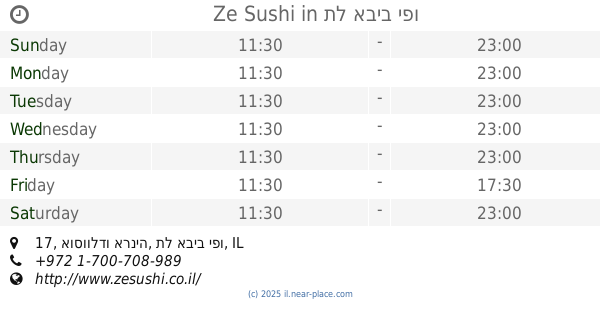
Ze Sushi
אוסוולדו ארניה 17, תל אביב יפו
Restaurant
read more
222 m
Флейшман
Tel Aviv-Yafo
Restaurant
read more
229 m
Kampai street Wok Sarona
מתחם שרונה, תל אביב יפו
Restaurant
read more
297 m
חומוס יוגי
קרליבך 18, תל אביב יפו
Restaurant
read more
416 m
לחם וחברים
Shlomo Ibn Gabirol Street 14, Tel Aviv-Yafo
Restaurant
read more
439 m
אולימפוס
קרליבך 7, תל אביב יפו
Restaurant
read more
498 m
Chop Chop
Shlomo Ibn Gabirol Street 20, Tel Aviv-Yafo
Restaurant
read more
501 m
פסטה מיאה
וילסון 10, תל אביב יפו
Restaurant
read more
521 m
בורגר פקטורי אקספרס
שלמה אבן גבירול 22, תל אביב יפו
Restaurant
read more
526 m
שניצליין
Lincoln Street 18, Tel Aviv-Yafo
Restaurant
read more
668 m
Black Azrieli Center
Azrieli Center, Derech Menachem Begin 132, Tel Aviv-Yafo
Restaurant
read more
778 m
Goomba
Yigal Alon Street 94a, Tel Aviv-Yafo
Restaurant
read more
837 m
מזנון בית משפט השלום
ויצמן 1, תל אביב יפו
Restaurant
read more
858 m
5 O
מזא"ה 49, תל אביב יפו
Restaurant
read more
903 m
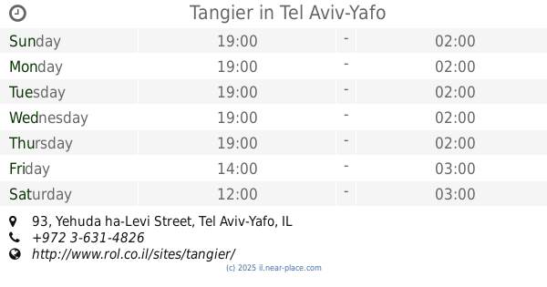
Tangier
Yehuda ha-Levi Street 93, Tel Aviv-Yafo
Restaurant
read more
956 m
שניצליין
Yad Harutsim Street 13, Tel Aviv-Yafo
Restaurant
read more
1.035 km
ספאגוס
השרון 14, תל אביב יפו
Restaurant
read more
1.042 km
טעמים
השרון 21, תל אביב יפו
Restaurant
read more
1.061 km
Ya Pan יא פאן
Nahmani Street 26, Tel Aviv-Yafo
Restaurant
read more
1.076 km
חומוס הבן של הסורי
יגאל אלון 121, תל אביב יפו
Restaurant
read more
1.104 km
Alena
Nahmani Street 23-25, Tel Aviv-Yafo
Restaurant
read more
1.111 km
Ilans coffee
Yigal Alon Street 51, Tel Aviv-Yafo
Restaurant
read more
1.15 km
26 המבורגר גורמה
מקווה ישראל 26, תל אביב יפו
Restaurant
read more
1.178 km
טאקרייה
לבונטין 28, תל אביב יפו
Restaurant
read more
📑
all categories
Accounting
Administrative area level 1
Administrative area level 2
Airport
Amusement park
Aquarium
Art gallery
Atm
Bakery
Bank
Bar
Beauty salon
Bicycle store
Book store
Bowling alley
Bus station
Cafe
Campground
Car dealer
Car rental
Car repair
Car wash
Casino
Cemetery
Church
City hall
Clothing store
Colloquial area
Convenience store
Country
Courthouse
Dentist
Department store
Doctor
Electrician
Electronics store
Embassy
Establishment
Finance
Fire station
Florist
Food
Funeral home
Furniture store
Gas station
General contractor
Grocery or supermarket
Gym
Hair care
Hardware store
Health
Hindu Temple
Home goods store
Hospital
Insurance agency
Intersection
Jewelry store
Laundry
Lawyer
Library
Light rail station
Liquor store
Local government office
Locality
Locksmith
Lodging
Meal delivery
Meal takeaway
Mosque
Movie rental
Movie theater
Moving company
Museum
Natural feature
Neighborhood
Night club
Painter
Park
Parking
Pet store
Pharmacy
Physiotherapist
Place of worship
Plumber
Point of interest
Police
Political
Post office
Premise
Real estate agency
Restaurant
Roofing contractor
Route
Rv park, camping
School
Shoe store
Shopping mall
Spa
Stadium
Storage
Store
Subpremise
Subway station
Supermarket
Synagogue
Taxi stand
Train station
Transit station
Travel agency
University
Veterinary care
Zoo
administrative area level 3
administrative area level 4
sublocality level 1
↑