Restaurant nearby Abu Omar Fishing
Israel
Restaurant nearby Abu Omar Fishing
Abu Omar Fishing
Джальджулия, Израиль
contacts phone
:
+972 3-939-6875
Latitude:
32.1503004
, Longitude:
34.9541556
larger map & directions
read more
nearest Restaurant
194 m
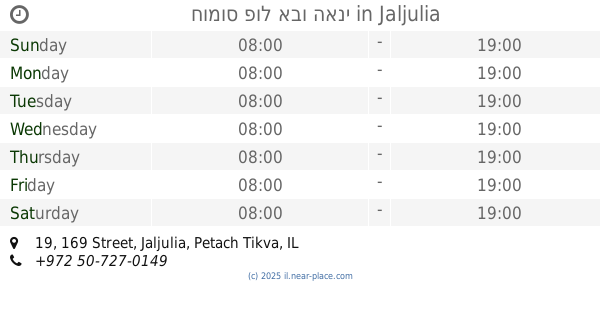
חומוס פול אבו האני
169 Street 19, Jaljulia
Restaurant
read more
287 m
מסעדת כרים חומוס פלאפל
ג'לג'וליה
Restaurant
read more
287 m
מסעדת כרים חומוס פלאפל
Jaljulia
Restaurant
read more
386 m
קנאפה גחגוליה
ג'לג'וליה
Restaurant
read more
386 m
קנאפה ג'לגוליה
ג'לג'וליה
Restaurant
read more
386 m
קנאפה ג'לגוליה
Jaljulia
Restaurant
read more
403 m
מפגש אל דייעה
Jaljulia
Restaurant
read more
655 m
מסעדת ריחן
משתלת הריחאן, ג'לג'וליה
Restaurant
read more
655 m
Rehan
משתלת הריחאן, ג'לג'וליה
Restaurant
read more
704 m
קוקו סוסים בעמ
37,, 133 Street 19, Jaljulia
Restaurant
read more
833 m
Abu Za'id the Bedouin Restaurant
תחנת דלק פז, חגור
Restaurant
read more
1.08 km
yuvburger
Yarhiv
Restaurant
read more
1.08 km
yuvburger
ירחיב
Restaurant
read more
2.059 km
פיצה דו רה מי
הדס 41, מתן
Restaurant
read more
2.059 km
פיצה דו רה מי
Hadas Street 41, Matan
Restaurant
read more
2.096 km
Ashkelon Pitza Store
merkaz Davidi, Ashkelon
Restaurant
read more
2.821 km
המקדש
עתיר ידע 4, כפר סבא
Restaurant
read more
2.944 km
שגב קונספט
אושילנד, עתיר ידע 2, כפר סבא
Restaurant
read more
2.949 km
Vitamin Bar
עתיר ידע 4, כפר סבא
Restaurant
read more
2.949 km
Mexicano
עתיר ידע 4, כפר סבא
Restaurant
read more
3.038 km
Pizza Market
Ha-Dekel Street 19, Neve Yamin
Restaurant
read more
3.513 km
שפע חומוס
HaMenofim Street 1, Kefar Sava
Restaurant
read more
3.513 km
שפע חומוס
המנופים 1, כפר סבא
Restaurant
read more
3.666 km
הטאבון
Kefar Sava
Restaurant
read more
3.842 km
בורגר כפר סבא
Ha-Nagar Street 6, Kefar Sava
Restaurant
read more
📑
all categories
Accounting
Administrative area level 1
Administrative area level 2
Airport
Amusement park
Aquarium
Art gallery
Atm
Bakery
Bank
Bar
Beauty salon
Bicycle store
Book store
Bowling alley
Bus station
Cafe
Campground
Car dealer
Car rental
Car repair
Car wash
Casino
Cemetery
Church
City hall
Clothing store
Colloquial area
Convenience store
Country
Courthouse
Dentist
Department store
Doctor
Electrician
Electronics store
Embassy
Establishment
Finance
Fire station
Florist
Food
Funeral home
Furniture store
Gas station
General contractor
Grocery or supermarket
Gym
Hair care
Hardware store
Health
Hindu Temple
Home goods store
Hospital
Insurance agency
Intersection
Jewelry store
Laundry
Lawyer
Library
Light rail station
Liquor store
Local government office
Locality
Locksmith
Lodging
Meal delivery
Meal takeaway
Mosque
Movie rental
Movie theater
Moving company
Museum
Natural feature
Neighborhood
Night club
Painter
Park
Parking
Pet store
Pharmacy
Physiotherapist
Place of worship
Plumber
Point of interest
Police
Political
Post office
Premise
Real estate agency
Restaurant
Roofing contractor
Route
Rv park, camping
School
Shoe store
Shopping mall
Spa
Stadium
Storage
Store
Subpremise
Subway station
Supermarket
Synagogue
Taxi stand
Train station
Transit station
Travel agency
University
Veterinary care
Zoo
administrative area level 3
administrative area level 4
sublocality level 1
↑