Restaurant nearby Abu Ali
Israel
Restaurant nearby Abu Ali
Abu Ali
סלאח א דין 10, Jerusalem
contacts phone
:
+972
Latitude:
31.7846604
, Longitude:
35.2320762
larger map & directions
read more
nearest Restaurant
448 m
Sarwa Street Kitchen
Salah e-Din Street 42, Jerusalem
Restaurant
read more
630 m
Lina
עקבת אל חנאכה 42, ירושלים
Restaurant
read more
657 m
DIANA'S B & B
10 Hulda HaNeviah Street, Musrara, POB 4030, 91040 Jerusalem, Jerusalem
Restaurant
read more
767 m
Allegro Bistro & Cafe
Notre Dame of Jerusalem Center, HaTsanhanim Street 3, Jerusalem
Restaurant
read more
790 m
Al-Sultan Restaurant
Suq Aftimos #7, Jerusalem Old City
Restaurant
read more
871 m
פיצה ביתית
חסידי קרלין 3, ירושלים
Restaurant
read more
893 m
פלאפל מירו
הרב זוננפלד 10, ירושלים
Restaurant
read more
924 m
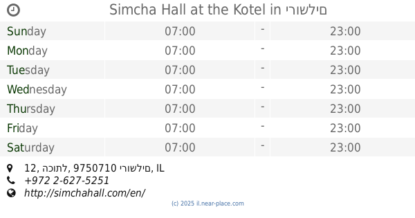
Simcha Hall at the Kotel
הכותל 12, ירושלים
Restaurant
read more
937 m
Deutch Restaurant
מאה שערים 50, ירושלים
Restaurant
read more
942 m
מסעדת דייטש
מאה שערים 32, ירושלים
Restaurant
read more
958 m
Rossini's Restaurant
הפטריארכיה הלטינית 42, ירושלים
Restaurant
read more
971 m
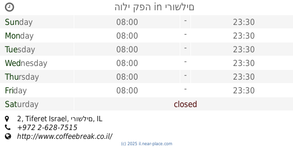
הולי קפה
Tiferet Israel 2, ירושלים
Restaurant
read more
1.022 km
Askadinya Restaurant
Shimon Ha-Tzadik 21, ירושלים
Restaurant
read more
1.032 km
Walia Ibex
ירושלים
Restaurant
read more
1.076 km
Rony's Pizza
Jaffa Street 25, Jerusalem
Restaurant
read more
1.08 km
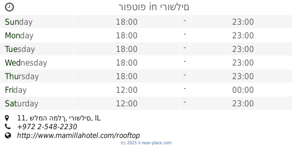
רופטופ
שלמה המלך 11, ירושלים
Restaurant
read more
1.082 km
מיאן נודלס
שלמה המלך 22, ירושלים
Restaurant
read more
1.091 km
אצה ירושלים
שלומציון המלכה 1, ירושלים
Restaurant
read more
1.115 km
Kadosh Café Patisserie
Queen Shlomziyon Street 6, Jerusalem
Restaurant
read more
1.117 km
Mangiare
Queen Shlomziyon Street 18, Jerusalem
Restaurant
read more
1.117 km
עג'מיס
שלומציון המלכה 17, ירושלים
Restaurant
read more
1.126 km
Black Bar 'n' Burger
Queen Shlomziyon Street 18, Jerusalem
Restaurant
read more
1.151 km
Ben Sira Hummus
Ben Sira Street 3, Jerusalem
Restaurant
read more
1.21 km
הפלאפל התימני
יואל 22, ירושלים
Restaurant
read more
1.285 km
JLM Local Sushi
10, King David, Jerusalem
Restaurant
read more
📑
all categories
Accounting
Administrative area level 1
Administrative area level 2
Airport
Amusement park
Aquarium
Art gallery
Atm
Bakery
Bank
Bar
Beauty salon
Bicycle store
Book store
Bowling alley
Bus station
Cafe
Campground
Car dealer
Car rental
Car repair
Car wash
Casino
Cemetery
Church
City hall
Clothing store
Colloquial area
Convenience store
Country
Courthouse
Dentist
Department store
Doctor
Electrician
Electronics store
Embassy
Establishment
Finance
Fire station
Florist
Food
Funeral home
Furniture store
Gas station
General contractor
Grocery or supermarket
Gym
Hair care
Hardware store
Health
Hindu Temple
Home goods store
Hospital
Insurance agency
Intersection
Jewelry store
Laundry
Lawyer
Library
Light rail station
Liquor store
Local government office
Locality
Locksmith
Lodging
Meal delivery
Meal takeaway
Mosque
Movie rental
Movie theater
Moving company
Museum
Natural feature
Neighborhood
Night club
Painter
Park
Parking
Pet store
Pharmacy
Physiotherapist
Place of worship
Plumber
Point of interest
Police
Political
Post office
Premise
Real estate agency
Restaurant
Roofing contractor
Route
Rv park, camping
School
Shoe store
Shopping mall
Spa
Stadium
Storage
Store
Subpremise
Subway station
Supermarket
Synagogue
Taxi stand
Train station
Transit station
Travel agency
University
Veterinary care
Zoo
administrative area level 3
administrative area level 4
sublocality level 1
↑