Place of worship nearby שיחי אל חמא
Israel
Place of worship nearby שיחי אל חמא
שיחי אל חמא
כינרת, ישראל
contacts phone
:
+972
Latitude:
32.7788183
, Longitude:
35.4274408
larger map & directions
read more
nearest Place of worship
3.651 km
קבר יתרו
כפר זיתים
Place of worship
read more
3.651 km
Nabi Shu'ayb
Kfar Zeitim
Place of worship
read more
4.092 km
ארקל אוטומוטיב
Ha-Plada Street
Place of worship
read more
4.092 km
ארקל אוטומוטיב
הפלדה
Place of worship
read more
5.936 km
Tomb of Rabbi Zera
Arbel
Place of worship
read more
5.936 km
קבר רבי זירא
ארבל
Place of worship
read more
9.185 km
Lavra Netofa
Deir Hanna
Place of worship
read more
9.829 km
Hamnuna Saba Tomb
Tiberias
Place of worship
read more
9.829 km
קבר התנא רב המנונא סבא
טבריה
Place of worship
read more
9.834 km
Huna Reish Galuta Tomb
Tiberias
Place of worship
read more
10.367 km
קבר אמי ואסי
טבריה
Place of worship
read more
10.374 km
Shelah Holy Tomb
Tiberias
Place of worship
read more
10.374 km
קבר השלה הקדוש
טבריה
Place of worship
read more
10.374 km
קבר הרמבם
טבריה
Place of worship
read more
10.87 km
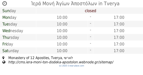
Ἱερά Μονή Ἁγίων Ἀποστόλων
Monastery of 12 Apostles
Place of worship
read more
10.919 km
Ιερά Μονή Αγίων Αποστόλων Εν Τιβεριάδω
Tiberias
Place of worship
read more
11.484 km
E-Sadiq Burial Cave
Arraba
Place of worship
read more
11.766 km
Re'uven Ben Itstrubali Tomb
Arraba
Place of worship
read more
14.32 km
Monasterio de la Sagrada Familia (Monjes Contemplativos del Instituto del Verbo Encarnado)
Tsipori
Place of worship
read more
14.61 km
Nebi Saeen Mosque
45, Ru'us el-Jibal Street 39, Nazareth
Place of worship
read more
14.758 km
Klasztor franciszkanów
Nazareth
Place of worship
read more
14.826 km
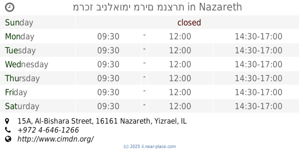
מרכז בינלאומי מרים מנצרת
Al-Bishara Street 15A, Nazareth
Place of worship
read more
15.908 km
NadSoft
Haifa Road 81, Nazareth
Place of worship
read more
18.051 km
Монастырь двенадцати апостолов
Israel
Place of worship
read more
18.078 km
Greek Orthodox Monastery
Israel
Place of worship
read more
📑
all categories
Accounting
Administrative area level 1
Administrative area level 2
Airport
Amusement park
Aquarium
Art gallery
Atm
Bakery
Bank
Bar
Beauty salon
Bicycle store
Book store
Bowling alley
Bus station
Cafe
Campground
Car dealer
Car rental
Car repair
Car wash
Casino
Cemetery
Church
City hall
Clothing store
Colloquial area
Convenience store
Country
Courthouse
Dentist
Department store
Doctor
Electrician
Electronics store
Embassy
Establishment
Finance
Fire station
Florist
Food
Funeral home
Furniture store
Gas station
General contractor
Grocery or supermarket
Gym
Hair care
Hardware store
Health
Hindu Temple
Home goods store
Hospital
Insurance agency
Intersection
Jewelry store
Laundry
Lawyer
Library
Light rail station
Liquor store
Local government office
Locality
Locksmith
Lodging
Meal delivery
Meal takeaway
Mosque
Movie rental
Movie theater
Moving company
Museum
Natural feature
Neighborhood
Night club
Painter
Park
Parking
Pet store
Pharmacy
Physiotherapist
Place of worship
Plumber
Point of interest
Police
Political
Post office
Premise
Real estate agency
Restaurant
Roofing contractor
Route
Rv park, camping
School
Shoe store
Shopping mall
Spa
Stadium
Storage
Store
Subpremise
Subway station
Supermarket
Synagogue
Taxi stand
Train station
Transit station
Travel agency
University
Veterinary care
Zoo
administrative area level 3
administrative area level 4
sublocality level 1
↑