Place of worship nearby Sepulcro de María
Israel
Place of worship nearby Sepulcro de María
Sepulcro de María
Jerusalén
contacts phone
:
+972
Latitude:
31.7801358
, Longitude:
35.239388
larger map & directions
read more
nearest Place of worship
Tomb of the Virgin
Jerusalem
Place of worship
read more
320 m
מערת יהושפט
ירושלים
Place of worship
read more
328 m
קבר אבשלום
ירושלים
Place of worship
read more
377 m
קבר רבי חיים בן עטר אור החיים הקדוש
ירושלים
Place of worship
read more
392 m
Temple Mount
Jerusalem
Place of worship
read more
394 m
קבר זכריה
ירושלים
Place of worship
read more
401 m
קבר בני חזיר
فلسطين, Jerusalem
Place of worship
read more
532 m
הכותל הקטן
Sha'ar ha-Barzel Street, Jerusalem
Place of worship
read more
532 m
הכותל הקטן
שער הברזל, ירושלים
Place of worship
read more
532 m
Little Western Wall
Sha'ar ha-Barzel Street, Jerusalem
Place of worship
read more
573 m
Базилика Ecce Homo
Via Dolorosa Street 41, Jerusalem
Place of worship
read more
573 m
Ecce Homo Convent
ויה דולורוזה 41, ירושלים
Place of worship
read more
597 m
Church of God Jerusalem
Al Mashrek Alley 2 #8
Place of worship
read more
597 m
Стена Плача
Jerusalem
Place of worship
read more
597 m
Western Wall
Jerusalem
Place of worship
read more
597 m
Ściana Płaczu
Jerusalem
Place of worship
read more
688 m
קבר רבי עובדיה מברטנורה
Jerusalem
Place of worship
read more
758 m
קבר בעל התורת חסד רבי שניאור זלמן פראדקין
ירושלים
Place of worship
read more
958 m
קבר הרב פתיה
Jerusalem
Place of worship
read more
962 m
The Garden Tomb Jerusalem
Conrad Schick Street, Jerusalem
Place of worship
read more
1.075 km
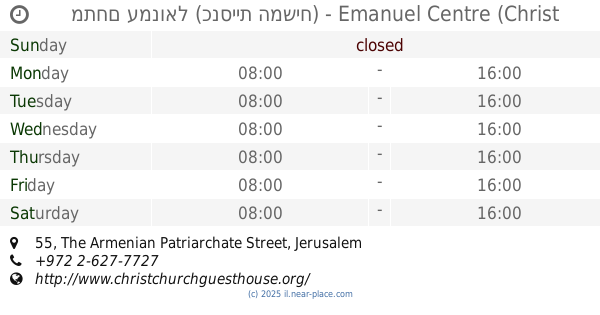
מתחם עמנואל (כנסיית המשיח) - Emanuel Centre (Christ Church)
The Armenian Patriarchate Street 55, Jerusalem
Cafe
Museum
Lodging
Church
Place of worship
Food
Point of interest
Establishment
read more
1.33 km
קבר דוד המלך
ירושלים
Place of worship
read more
1.33 km
Могила короля Давида
Jerusalem
Place of worship
read more
1.357 km
כנסיית הדורמיציון
ירושלים
Place of worship
read more
1.357 km
Дормишен Абби
Jerusalem
Place of worship
read more
📑
all categories
Accounting
Administrative area level 1
Administrative area level 2
Airport
Amusement park
Aquarium
Art gallery
Atm
Bakery
Bank
Bar
Beauty salon
Bicycle store
Book store
Bowling alley
Bus station
Cafe
Campground
Car dealer
Car rental
Car repair
Car wash
Casino
Cemetery
Church
City hall
Clothing store
Colloquial area
Convenience store
Country
Courthouse
Dentist
Department store
Doctor
Electrician
Electronics store
Embassy
Establishment
Finance
Fire station
Florist
Food
Funeral home
Furniture store
Gas station
General contractor
Grocery or supermarket
Gym
Hair care
Hardware store
Health
Hindu Temple
Home goods store
Hospital
Insurance agency
Intersection
Jewelry store
Laundry
Lawyer
Library
Light rail station
Liquor store
Local government office
Locality
Locksmith
Lodging
Meal delivery
Meal takeaway
Mosque
Movie rental
Movie theater
Moving company
Museum
Natural feature
Neighborhood
Night club
Painter
Park
Parking
Pet store
Pharmacy
Physiotherapist
Place of worship
Plumber
Point of interest
Police
Political
Post office
Premise
Real estate agency
Restaurant
Roofing contractor
Route
Rv park, camping
School
Shoe store
Shopping mall
Spa
Stadium
Storage
Store
Subpremise
Subway station
Supermarket
Synagogue
Taxi stand
Train station
Transit station
Travel agency
University
Veterinary care
Zoo
administrative area level 3
administrative area level 4
sublocality level 1
↑