Place of worship nearby מנזר הצבאים
Coronavirus disease (COVID-19) Situation
confirmed cases
4841772
deaths
12707
Israel
Place of worship nearby מנזר הצבאים
מנזר הצבאים
ירושלים
contacts phone
:
+972
Latitude:
31.820241
, Longitude:
35.2519426
larger map & directions
read more
nearest Place of worship
2.3 km
בית מדרש ושטיבלך קהילת בני הישיבות נווה יעקב
מעגלות הרב פרדס 33, ירושלים
Place of worship
read more
2.3 km
בית מדרש ושטיבלך קהילת בני הישיבות נווה יעקב
Ma'agalot HaRav Pardes Street 33, Jerusalem
Place of worship
read more
3.184 km
Synagogue Ner Yosef
Jerusalem
Place of worship
read more
4.096 km
Beit Midrash Bad Ischl
Petahia Street 2, Jerusalem
Place of worship
read more
4.349 km
Jerusalem Prayer Center
Nablus Road 76, Jerusalem
Place of worship
read more
4.349 km
Jerusalem Prayer Center
דרך שכם 76, ירושלים
Place of worship
read more
4.462 km
תת אור שרגא
Yisa Bracha Street 37, Jerusalem
Place of worship
read more
4.527 km
הארמון
Ezra Street 19, Jerusalem
Place of worship
read more
4.64 km
דום פולסקי
החומה השלישית 8, ירושלים
Place of worship
read more
4.65 km
שול ברסלב
Me'a She'arim Street 108, Jerusalem
Place of worship
read more
4.708 km
ארגון טהרת הבית בניית מקוואות לשם שמים
22,, Yona Street 6, Jerusalem
Place of worship
read more
4.771 km
Ecce Homo Convent
ויה דולורוזה 41, ירושלים
Place of worship
read more
4.806 km
מוסדות קאליב
חנה 32, ירושלים
Place of worship
read more
4.932 km
מערת יהושפט
ירושלים
Place of worship
read more
4.94 km
הכותל הקטן
Sha'ar ha-Barzel Street, Jerusalem
Place of worship
read more
4.94 km
Little Western Wall
Sha'ar ha-Barzel Street, Jerusalem
Place of worship
read more
4.984 km
קבר רבי חיים בן עטר אור החיים הקדוש
ירושלים
Place of worship
read more
5.112 km
Ściana Płaczu
Jerusalem
Place of worship
read more
5.112 km
Western Wall
Jerusalem
Place of worship
read more
5.364 km
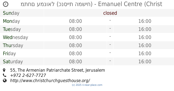
מתחם עמנואל (כנסיית המשיח) - Emanuel Centre (Christ Church)
The Armenian Patriarchate Street 55, Jerusalem
Cafe
Museum
Lodging
Church
Place of worship
Food
Point of interest
Establishment
read more
5.595 km
Ahavat Shalom V'Ohel Moshe
דוד המלך 10, ירושלים
Place of worship
read more
5.71 km
Great Synagogue Ades of the Glorious Community of Aleppo
Shilo Street 50, Jerusalem
Place of worship
read more
6.015 km
Golgotava Gora
31.778471; 35.229421
Place of worship
read more
6.174 km
Mikvah Nachlaot
7, Rechov Hanaziv, Ha-Nadiv Street, Giv'atayim
Place of worship
read more
6.254 km
Zeller Rebbe Grave Site
רוטשילד, ירושלים
Place of worship
read more
📑
all categories
Accounting
Administrative area level 1
Administrative area level 2
Airport
Amusement park
Aquarium
Art gallery
Atm
Bakery
Bank
Bar
Beauty salon
Bicycle store
Book store
Bowling alley
Bus station
Cafe
Campground
Car dealer
Car rental
Car repair
Car wash
Casino
Cemetery
Church
City hall
Clothing store
Colloquial area
Convenience store
Country
Courthouse
Dentist
Department store
Doctor
Electrician
Electronics store
Embassy
Establishment
Finance
Fire station
Florist
Food
Funeral home
Furniture store
Gas station
General contractor
Grocery or supermarket
Gym
Hair care
Hardware store
Health
Hindu Temple
Home goods store
Hospital
Insurance agency
Intersection
Jewelry store
Laundry
Lawyer
Library
Light rail station
Liquor store
Local government office
Locality
Locksmith
Lodging
Meal delivery
Meal takeaway
Mosque
Movie rental
Movie theater
Moving company
Museum
Natural feature
Neighborhood
Night club
Painter
Park
Parking
Pet store
Pharmacy
Physiotherapist
Place of worship
Plumber
Point of interest
Police
Political
Post office
Premise
Real estate agency
Restaurant
Roofing contractor
Route
Rv park, camping
School
Shoe store
Shopping mall
Spa
Stadium
Storage
Store
Subpremise
Subway station
Supermarket
Synagogue
Taxi stand
Train station
Transit station
Travel agency
University
Veterinary care
Zoo
administrative area level 3
administrative area level 4
sublocality level 1
↑