Pharmacy nearby صيدلية قاسم
Israel
Pharmacy nearby صيدلية قاسم
صيدلية قاسم
Hazi Abdul Matin Road, President Nagar
contacts phone
:
+970 598 344 243
Latitude:
32.1920146
, Longitude:
35.1582285
larger map & directions
read more
nearest Pharmacy
8.043 km
صيدلية نغم
Pharmacy
read more
8.818 km
Al-Fayhaa' Pharmacy
شارع عمر بن الخطاب ،محافظة نابلس ، نابلس Nablus
Pharmacy
read more
9.272 km
Nour alyousef pharmacy
An Najah old campus street Nablus
Pharmacy
read more
9.349 km
Fawaz Pharmacy
9، Hadera
Pharmacy
read more
9.697 km
Sabri Pharmacy
32.22465,35.253809
Pharmacy
read more
9.711 km
אריאל פרמה טבע
מרכז מסחרי, יהודה 10, אריאל
Pharmacy
read more
9.905 km
Sana Pharmacy
Ibn Sina
Pharmacy
read more
9.955 km
Khurshid Pharmacy
32.221137,35.258283
Pharmacy
read more
10.016 km
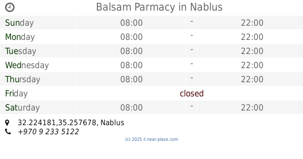
Balsam Parmacy
32.224181,35.257678
Pharmacy
read more
10.073 km
Anaam Pharmacy
32.221005,35.259669
Pharmacy
read more
10.15 km
Aslan Pharmacy
32.221064,35.260503
Pharmacy
read more
10.356 km
Ibn Sina Pharmacy
Nablus
Pharmacy
read more
10.406 km
Perfect Pharmacy
Pharmacy
read more
11.817 km
Pharma Center Pharmacy
Biddya
Pharmacy
read more
12.817 km
صيدلية الزغل العصرية Modern Zaghal Pharmacy
Rujeib street, Nablus
Pharmacy
read more
13.739 km
Be'eri
Alfei Menashe
Pharmacy
read more
14.694 km
Поликлиника Клалит
מרכז מסחרי, אלקנה
Pharmacy
read more
16.128 km
א.פארם טייבה
רחוב 24 צפון, טייבה
Pharmacy
read more
16.128 km
A.farm Taybeh
רחוב 24 צפון, Tayibe
Pharmacy
read more
16.369 km
ZEYAD pharmacy
faroon main street فرعون الشارع الرئيسي, Tulkarm
Pharmacy
read more
16.75 km
صيدلية الحياة- الطيبة
Tayibe
Pharmacy
read more
16.75 km
صيدلية الحياة- الطيبة
טייבה
Pharmacy
read more
16.758 km
בית מרקחת אלחיאת טייבה صيدلية الحياة الطيبة
טייבה
Pharmacy
read more
18.047 km
صيدلية وسيم
طولكرم,الشارع الرئيسي,مقابل البلديه
Pharmacy
read more
18.228 km
Flower cities Pharmacy
Pharmacy
read more
📑
all categories
Accounting
Administrative area level 1
Administrative area level 2
Airport
Amusement park
Aquarium
Art gallery
Atm
Bakery
Bank
Bar
Beauty salon
Bicycle store
Book store
Bowling alley
Bus station
Cafe
Campground
Car dealer
Car rental
Car repair
Car wash
Casino
Cemetery
Church
City hall
Clothing store
Colloquial area
Convenience store
Country
Courthouse
Dentist
Department store
Doctor
Electrician
Electronics store
Embassy
Establishment
Finance
Fire station
Florist
Food
Funeral home
Furniture store
Gas station
General contractor
Grocery or supermarket
Gym
Hair care
Hardware store
Health
Hindu Temple
Home goods store
Hospital
Insurance agency
Intersection
Jewelry store
Laundry
Lawyer
Library
Light rail station
Liquor store
Local government office
Locality
Locksmith
Lodging
Meal delivery
Meal takeaway
Mosque
Movie rental
Movie theater
Moving company
Museum
Natural feature
Neighborhood
Night club
Painter
Park
Parking
Pet store
Pharmacy
Physiotherapist
Place of worship
Plumber
Point of interest
Police
Political
Post office
Premise
Real estate agency
Restaurant
Roofing contractor
Route
Rv park, camping
School
Shoe store
Shopping mall
Spa
Stadium
Storage
Store
Subpremise
Subway station
Supermarket
Synagogue
Taxi stand
Train station
Transit station
Travel agency
University
Veterinary care
Zoo
administrative area level 3
administrative area level 4
sublocality level 1
↑