Pharmacy nearby صيدلية برا فارما
Israel
Pharmacy nearby صيدلية برا فارما
صيدلية برا فارما
Unnamed Road, Kafr Bara, ישראל
contacts phone
:
+972 3-910-2816
Latitude:
32.1310199
, Longitude:
34.9718223
larger map & directions
read more
nearest Pharmacy
1.61 km
סולטאני
כפר קאסם
Pharmacy
read more
1.61 km
Sultani
Kafr Qasim
Pharmacy
read more
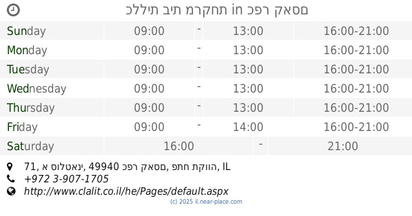
1.782 km
כללית בית מרקחת
א סולטאני 71, כפר קאסם
Pharmacy
read more
1.782 km
Поликлиника Клалит
E-Sultani Street 71, Kafr Qasim
Pharmacy
read more
1.821 km
Поликлиника Клалит
Kafr Qasim
Pharmacy
read more
1.821 km
כללית בית מרקחת
כפר קאסם
Pharmacy
read more
1.943 km
שוכרי פארם
Omar Ben el-Khatab Street, Kafr Qasim
Pharmacy
read more
1.943 km
שוכרי פארם
עומר בן אל ח'טאב, כפר קאסם
Pharmacy
read more
2.263 km
ש.ר.מ. פארם, בית מרקחת אורנית
מרכז מסחרי, Oranit
Pharmacy
read more
2.5 km
עדי יוגב אלצפון - רפואה בדרך טבעית
איילון 6ב, Oranit
Pharmacy
read more
3.123 km
בית מרקחת מתן
המסחרי, Hadar Street 84, Matan
Pharmacy
read more
3.313 km
בית מרקחת הלא
122 20, ג'לג'וליה
Pharmacy
read more
4.055 km
Clalit - Pharmacy
Mivtsa Bazak Street 1, Rosh Haayin
Pharmacy
read more
4.182 km
Поликлиника Клалит
Mivtsa Bazak Street 1, Rosh Haayin
Pharmacy
read more
4.185 km
שוכרי פארם - בית מרקחת
ראש העין
Pharmacy
read more
4.185 km
S.r.m Farm - Savyon Pharmacy
Rosh Haayin
Pharmacy
read more
4.249 km
Super-Pharm Givat Tal
Moshe Dayan Street 2, Rosh Haayin
Pharmacy
read more
4.351 km
בית מרקחת מדיקה
זכריה משה 4, ראש העין
Pharmacy
read more
4.537 km
MEDICA Ras al-Ain
Rosh Haayin
Pharmacy
read more
4.567 km
סופר-פארם שבזי ראש העין
שבזי 10, Rosh Haayin
Pharmacy
read more
4.578 km
Супер-Фарм
Ha-Rav Shalom Shabazi Street 10, Rosh Haayin
Pharmacy
read more
4.578 km
Super-Pharm
Ha-Rav Shalom Shabazi Street 10, Rosh Haayin
Pharmacy
read more
4.8 km
דממ סוכנויות
Atir Yeda Street 21, Kefar Sava
Pharmacy
read more
4.922 km
Afek
Rosh Haayin
Pharmacy
read more
6.013 km
Be'eri
Alfei Menashe
Pharmacy
read more
📑
all categories
Accounting
Administrative area level 1
Administrative area level 2
Airport
Amusement park
Aquarium
Art gallery
Atm
Bakery
Bank
Bar
Beauty salon
Bicycle store
Book store
Bowling alley
Bus station
Cafe
Campground
Car dealer
Car rental
Car repair
Car wash
Casino
Cemetery
Church
City hall
Clothing store
Colloquial area
Convenience store
Country
Courthouse
Dentist
Department store
Doctor
Electrician
Electronics store
Embassy
Establishment
Finance
Fire station
Florist
Food
Funeral home
Furniture store
Gas station
General contractor
Grocery or supermarket
Gym
Hair care
Hardware store
Health
Hindu Temple
Home goods store
Hospital
Insurance agency
Intersection
Jewelry store
Laundry
Lawyer
Library
Light rail station
Liquor store
Local government office
Locality
Locksmith
Lodging
Meal delivery
Meal takeaway
Mosque
Movie rental
Movie theater
Moving company
Museum
Natural feature
Neighborhood
Night club
Painter
Park
Parking
Pet store
Pharmacy
Physiotherapist
Place of worship
Plumber
Point of interest
Police
Political
Post office
Premise
Real estate agency
Restaurant
Roofing contractor
Route
Rv park, camping
School
Shoe store
Shopping mall
Spa
Stadium
Storage
Store
Subpremise
Subway station
Supermarket
Synagogue
Taxi stand
Train station
Transit station
Travel agency
University
Veterinary care
Zoo
administrative area level 3
administrative area level 4
sublocality level 1
↑