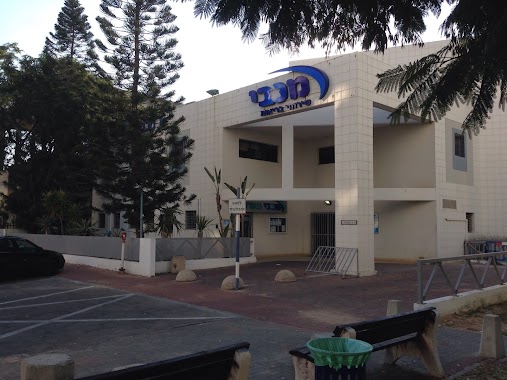
Pharmacy nearby סופר-פארם הגדוד העברי אשדוד
Israel
Pharmacy nearby סופר-פארם הגדוד העברי אשדוד
סופר-פארם הגדוד העברי אשדוד
הגדוד העברי 5, Ashdod, Israel
contacts phone
:
+972 77-888-1970
website:
www.super-pharm.co.il
Latitude:
31.791914
, Longitude:
34.638836
larger map & directions
read more
nearest Pharmacy
72 m
Супер-Фарм
Ashdod
Pharmacy
read more
72 m
סופר פארם גן העיר אשדוד
אשדוד
Pharmacy
read more
212 m
ניו פארם אשדוד הסיטי
Ashdod
Pharmacy
read more
212 m
ניו פארם אשדוד הסיטי
אשדוד
Pharmacy
read more
212 m
New Pharm
Ashdod
Pharmacy
read more
326 m
Поликлиника Клалит
HaBanim Street 1, Ashdod
Pharmacy
read more
326 m
Clalit Pharmacy
HaBanim Street 1, Ashdod
Pharmacy
read more
351 m
Super-Farm Ashdod City
HaBanim Street 1, Ashdod
Pharmacy
read more
351 m
סופר פארם אשדוד סיטי
הבנים 1, אשדוד
Pharmacy
read more
638 m
Ma'ayan Hayim Hacity
Ashdod
Pharmacy
read more
878 m
Maccabi Ashdod
Ha-Shayatim Street 12, Ashdod
Pharmacy
read more
878 m
מכבי בית מרקחת אשדוד
השייטים 12, אשדוד
Pharmacy
read more
991 m
היפר פארם אמפורה
אשדוד
Pharmacy
read more
993 m
שפירא
Haim Moshe Shapira Street 22, Ashdod
Pharmacy
read more
1.032 km
ניו פארם קניון לב אשדוד
קניון לב, יהודה הלוי 1, אשדוד
Pharmacy
read more
1.047 km
New Pharm Ashdod
Yehuda Halevi Street 1, Ashdod
Pharmacy
read more
1.047 km
ניו פארם קניון לב אשדוד
יהודה הלוי 1, אשדוד
Pharmacy
read more
1.157 km
כללית - בית מרקחת
זלמן ארן 19, אשדוד
Pharmacy
read more
1.157 km
Clalit Pharmacy
Zalman Aran Street 19, Ashdod
Pharmacy
read more
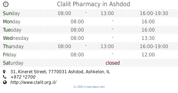
1.228 km
Clalit Pharmacy
Kineret Street 31, Ashdod
Pharmacy
read more
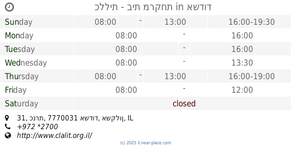
1.228 km
כללית - בית מרקחת
כנרת 31, אשדוד
Pharmacy
read more
1.245 km
Dan Darej Hmak
Ashdod
Pharmacy
read more
1.31 km
Rogozin
Ashdod
Pharmacy
read more
1.915 km
כללית בית מרקחת
שבי ציון 12, אשדוד
Pharmacy
read more
2.067 km
אביב
אשדוד
Pharmacy
read more
📑
all categories
Accounting
Administrative area level 1
Administrative area level 2
Airport
Amusement park
Aquarium
Art gallery
Atm
Bakery
Bank
Bar
Beauty salon
Bicycle store
Book store
Bowling alley
Bus station
Cafe
Campground
Car dealer
Car rental
Car repair
Car wash
Casino
Cemetery
Church
City hall
Clothing store
Colloquial area
Convenience store
Country
Courthouse
Dentist
Department store
Doctor
Electrician
Electronics store
Embassy
Establishment
Finance
Fire station
Florist
Food
Funeral home
Furniture store
Gas station
General contractor
Grocery or supermarket
Gym
Hair care
Hardware store
Health
Hindu Temple
Home goods store
Hospital
Insurance agency
Intersection
Jewelry store
Laundry
Lawyer
Library
Light rail station
Liquor store
Local government office
Locality
Locksmith
Lodging
Meal delivery
Meal takeaway
Mosque
Movie rental
Movie theater
Moving company
Museum
Natural feature
Neighborhood
Night club
Painter
Park
Parking
Pet store
Pharmacy
Physiotherapist
Place of worship
Plumber
Point of interest
Police
Political
Post office
Premise
Real estate agency
Restaurant
Roofing contractor
Route
Rv park, camping
School
Shoe store
Shopping mall
Spa
Stadium
Storage
Store
Subpremise
Subway station
Supermarket
Synagogue
Taxi stand
Train station
Transit station
Travel agency
University
Veterinary care
Zoo
administrative area level 3
administrative area level 4
sublocality level 1
↑