Pharmacy nearby Super-Pharm
Israel
Pharmacy nearby Super-Pharm
Super-Pharm
Kokhav Ya'ir Tzur Yigal, Israel
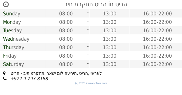
contacts phone
:
+972
Latitude:
32.220922
, Longitude:
34.992405
larger map & directions
read more
nearest Pharmacy
929 m
Супер-Фарм
א.ת. צומת כוכב יאיר, Kokhav Ya'ir Tzur Yigal
Pharmacy
read more
929 m
סופר-פארם כוכב יאיר
א.ת. צומת כוכב יאיר, Kokhav Ya'ir Tzur Yigal
Pharmacy
read more
929 m
Super-Pharm
א.ת. צומת כוכב יאיר, Kokhav Ya'ir Tzur Yigal
Pharmacy
read more
1.026 km
כללית בית מרקחת
מרכז מסחרי סורגל, סניף קוסמוס, מצפה ספיר, כוכב יאיר צור יגאל
Pharmacy
read more
1.026 km
כללית בית מרקחת
מרכז מסחרי סורגל, סניף קוסמוס, מצפה ספיר, Kokhav Ya'ir Tzur Yigal
Pharmacy
read more
1.069 km
היפר פארם צור יגאל
כוכב יאיר צור יגאל
Pharmacy
read more
1.069 km
Tsur Yig'al Hiper Pharm
Kokhav Ya'ir Tzur Yigal
Pharmacy
read more
2.953 km
صيدلية السلاندم
קלקיליה
Pharmacy
read more
3.871 km
בית מרקחת טירה
טירה - בית מרקחת, ראשי מול העיריה, טירה
Pharmacy
read more
3.877 km
אסמא
טירה
Pharmacy
read more
3.94 km
صيدلية الإسراء
almadares street, qalqilia, west bank, israel 00972
Pharmacy
read more
4.086 km
Pharmacy Razi
סלאם, קלקליה
Pharmacy
read more
4.101 km
صيدلية دلال Dallal Pharmacy
קלקיליה
Pharmacy
read more
4.101 km
صيدلية دلال Dallal Pharmacy
Qalqilya
Pharmacy
read more
4.271 km
אבו עזמי
טירה
Pharmacy
read more
4.294 km
صيدلية أبو سير
قلقيلية - السوق 00972
Pharmacy
read more
4.327 km
صيدلية الحياة
فلسطين الضفة الغربية 00972, Qalqilya
Pharmacy
read more
4.33 km
Salam Pharmacy
Main Street
Pharmacy
read more
4.352 km
صيدلية الخلافة
qalqilia/west bank/ 00970
Pharmacy
read more
4.354 km
Farmacia
טייבה
Pharmacy
read more
4.381 km
Pharmacy mercy
El-Shayma
Pharmacy
read more
4.404 km
صيدلية امجد
الضفة الغربية الشارع الغربي00970, Qalqilya
Pharmacy
read more
4.482 km
صيدلية اوس
israel - west bank - qalqilia
Pharmacy
read more
4.544 km
Hashem Pharmacy
فلسطين الضفة الغربية وسط السوق, الشارع الرئيسي - مقابل حلويات أبو جبارة, Qalqilya
Pharmacy
read more
4.714 km
Dean of Pharmacy
شارع جلجولية, قلقيلية
Pharmacy
read more
📑
all categories
Accounting
Administrative area level 1
Administrative area level 2
Airport
Amusement park
Aquarium
Art gallery
Atm
Bakery
Bank
Bar
Beauty salon
Bicycle store
Book store
Bowling alley
Bus station
Cafe
Campground
Car dealer
Car rental
Car repair
Car wash
Casino
Cemetery
Church
City hall
Clothing store
Colloquial area
Convenience store
Country
Courthouse
Dentist
Department store
Doctor
Electrician
Electronics store
Embassy
Establishment
Finance
Fire station
Florist
Food
Funeral home
Furniture store
Gas station
General contractor
Grocery or supermarket
Gym
Hair care
Hardware store
Health
Hindu Temple
Home goods store
Hospital
Insurance agency
Intersection
Jewelry store
Laundry
Lawyer
Library
Light rail station
Liquor store
Local government office
Locality
Locksmith
Lodging
Meal delivery
Meal takeaway
Mosque
Movie rental
Movie theater
Moving company
Museum
Natural feature
Neighborhood
Night club
Painter
Park
Parking
Pet store
Pharmacy
Physiotherapist
Place of worship
Plumber
Point of interest
Police
Political
Post office
Premise
Real estate agency
Restaurant
Roofing contractor
Route
Rv park, camping
School
Shoe store
Shopping mall
Spa
Stadium
Storage
Store
Subpremise
Subway station
Supermarket
Synagogue
Taxi stand
Train station
Transit station
Travel agency
University
Veterinary care
Zoo
administrative area level 3
administrative area level 4
sublocality level 1
↑