Pharmacy nearby מקסי פארם ברוכים גוש 80
Coronavirus disease (COVID-19) Situation
confirmed cases
4841772
deaths
12707
Israel
Pharmacy nearby מקסי פארם ברוכים גוש 80
מקסי פארם ברוכים גוש 80
9, חכם שמואל ברוכים, ירושלים, IL ישראל
contacts phone
:
+972 2-538-8950
Latitude:
31.7952229
, Longitude:
35.2156833
larger map & directions
read more
nearest Pharmacy
341 m
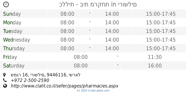
כללית בית מרקחת
שדרות גולדה מאיר 25, ירושלים
Pharmacy
read more
341 m
Clalit Pharmacy
Golda Me'ir Boulevard 25, Jerusalem
Pharmacy
read more
363 m
כללית בית מרקחת
בר אילן 2, ירושלים
Pharmacy
read more
363 m
Clalit Pharmacy
Bar Ilan 2, Jerusalem
Pharmacy
read more
363 m
Поликлиника Клалит
Bar Ilan 2, Jerusalem
Pharmacy
read more
366 m
Medi Plus
Bar Ilan 2, Jerusalem
Pharmacy
read more
528 m
Купат Холим Меухедет
иерушалаим 15, Rehovot
Pharmacy
read more
577 m
Express Pharm
Yekhezkel Street 31, Jerusalem
Pharmacy
read more
690 m
Clalit Pharmacy
שמגר 16, Jerusalem
Pharmacy
read more
690 m
כללית - בית מרקחת
שמגר 16, ירושלים
Pharmacy
read more
713 m
Geula Pharmacy
Malkei Israel Street 14, Jerusalem
Pharmacy
read more
713 m
בית מרקחת גאולה
Malkei Israel Street 14, Jerusalem
Pharmacy
read more
821 m
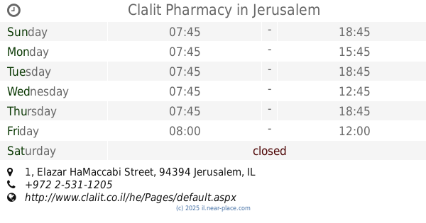
Clalit
Elazar HaMaccabi Street 1, Jerusalem
Pharmacy
read more
821 m
Clalit Pharmacy
Elazar HaMaccabi Street 1, Jerusalem
Pharmacy
read more
821 m
Поликлиника Клалит
Elazar HaMaccabi Street 1, Jerusalem
Pharmacy
read more
981 m
Rina Pharm
David Yellin Street 31, Jerusalem
Pharmacy
read more
981 m
רינה-פארם
דוד ילין 31, ירושלים
Pharmacy
read more
1.206 km
Sigma-Aldrich-Merck
קרית המדע 15, ירושלים
Pharmacy
read more
1.206 km
Sigma-Aldrich-Merck
Kiryat HaMada Street 15, Jerusalem
Pharmacy
read more
1.319 km
Meuhedet
Panim Meirot Street 16, Jerusalem
Pharmacy
read more
1.389 km
סנטר פארם פעמון
ירושלים
Pharmacy
read more
1.414 km
Ha'Amudim
Jerusalem
Pharmacy
read more
1.42 km
Clalit Pharmacy
Me'a She'arim Street 83, Jerusalem
Pharmacy
read more
1.481 km
Поликлиника Клалит
HaMem Gimel Street 28, Jerusalem
Pharmacy
read more
2.409 km
Поликлиника Клалит
קרני יהודה 131, Jerusalem
Pharmacy
read more
📑
all categories
Accounting
Administrative area level 1
Administrative area level 2
Airport
Amusement park
Aquarium
Art gallery
Atm
Bakery
Bank
Bar
Beauty salon
Bicycle store
Book store
Bowling alley
Bus station
Cafe
Campground
Car dealer
Car rental
Car repair
Car wash
Casino
Cemetery
Church
City hall
Clothing store
Colloquial area
Convenience store
Country
Courthouse
Dentist
Department store
Doctor
Electrician
Electronics store
Embassy
Establishment
Finance
Fire station
Florist
Food
Funeral home
Furniture store
Gas station
General contractor
Grocery or supermarket
Gym
Hair care
Hardware store
Health
Hindu Temple
Home goods store
Hospital
Insurance agency
Intersection
Jewelry store
Laundry
Lawyer
Library
Light rail station
Liquor store
Local government office
Locality
Locksmith
Lodging
Meal delivery
Meal takeaway
Mosque
Movie rental
Movie theater
Moving company
Museum
Natural feature
Neighborhood
Night club
Painter
Park
Parking
Pet store
Pharmacy
Physiotherapist
Place of worship
Plumber
Point of interest
Police
Political
Post office
Premise
Real estate agency
Restaurant
Roofing contractor
Route
Rv park, camping
School
Shoe store
Shopping mall
Spa
Stadium
Storage
Store
Subpremise
Subway station
Supermarket
Synagogue
Taxi stand
Train station
Transit station
Travel agency
University
Veterinary care
Zoo
administrative area level 3
administrative area level 4
sublocality level 1
↑