Pharmacy nearby Health Pharmacy
Israel
Pharmacy nearby Health Pharmacy
Health Pharmacy
46, Eliyahu Krauze Street, Holon, IL Израиль
contacts phone
:
+972 3-504-1911
website:
www.briutpharm.com
Latitude:
32.02232
, Longitude:
34.7813474
larger map & directions
read more
nearest Pharmacy
321 m
Good Pharm
Sokolov Street 80, Holon
Pharmacy
read more
321 m
Good Pharm
סוקולוב 80, חולון
Pharmacy
read more
357 m
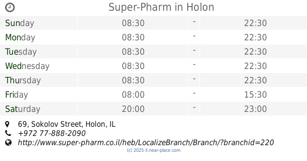
Супер-Фарм
Sokolov Street 69, Holon
Pharmacy
read more
357 m
Super-Pharm
Sokolov Street 69, Holon
Pharmacy
read more
376 m
כללית בית מרקחת
יהושע חנקין 71, חולון
Pharmacy
read more
376 m
Поликлиника Клалит
Yehoshua Hankin Street 71, Holon
Pharmacy
read more
376 m
Clalit Pharmacy
Yehoshua Hankin Street 71, Holon
Pharmacy
read more
381 m
Holon New Pharm
Holon
Pharmacy
read more
381 m
ניו פארם חולון
חולון
Pharmacy
read more
399 m
Merah Farm
Holon
Pharmacy
read more
491 m
Поликлиника Леумит
Sokolov Street 51, Holon
Pharmacy
read more
491 m
Leumit Health Care Services
Sokolov Street 51, Holon
Pharmacy
read more
491 m
קופת חולים לאומית
סוקולוב 51, חולון
Pharmacy
read more
610 m
HaMerkaz Kikar Weizman
Holon
Pharmacy
read more
617 m
בית מרקחת מרכז חולון - לורנס
Kikar Weizmann 12, Holon
Pharmacy
read more
619 m
Макаби Фарм
Sderot Kugel 45, Holon
Pharmacy
read more
622 m
Maccabi
רח, Sderot Kugel 45, Holon
Pharmacy
read more
629 m
Clalit Pharmacy
HaEshel Street 2, Holon
Pharmacy
read more
629 m
כללית - בית מרקחת
האשל 2, חולון
Pharmacy
read more
854 m
Ne'ot Shoshanim Pharmacy
Ge'ulim Street 44, Holon
Pharmacy
read more
854 m
בית מרקחת נאות שושנים בעמ
גאולים 44, חולון
Pharmacy
read more
906 m
מקס פארם ויטמינים
פרופסור משה שור 16, חולון
Pharmacy
read more
957 m
Поликлиника Клалит
Kaplan Street 15, Holon
Pharmacy
read more
1.072 km
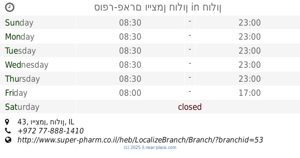
סופר-פארם וייצמן חולון
וייצמן 43, חולון
Pharmacy
read more
1.348 km
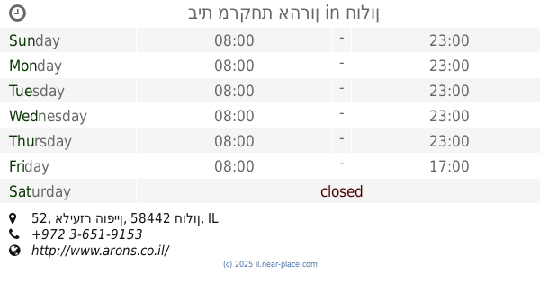
בית מרקחת אהרון
אליעזר הופיין 52, חולון
Pharmacy
read more
📑
all categories
Accounting
Administrative area level 1
Administrative area level 2
Airport
Amusement park
Aquarium
Art gallery
Atm
Bakery
Bank
Bar
Beauty salon
Bicycle store
Book store
Bowling alley
Bus station
Cafe
Campground
Car dealer
Car rental
Car repair
Car wash
Casino
Cemetery
Church
City hall
Clothing store
Colloquial area
Convenience store
Country
Courthouse
Dentist
Department store
Doctor
Electrician
Electronics store
Embassy
Establishment
Finance
Fire station
Florist
Food
Funeral home
Furniture store
Gas station
General contractor
Grocery or supermarket
Gym
Hair care
Hardware store
Health
Hindu Temple
Home goods store
Hospital
Insurance agency
Intersection
Jewelry store
Laundry
Lawyer
Library
Light rail station
Liquor store
Local government office
Locality
Locksmith
Lodging
Meal delivery
Meal takeaway
Mosque
Movie rental
Movie theater
Moving company
Museum
Natural feature
Neighborhood
Night club
Painter
Park
Parking
Pet store
Pharmacy
Physiotherapist
Place of worship
Plumber
Point of interest
Police
Political
Post office
Premise
Real estate agency
Restaurant
Roofing contractor
Route
Rv park, camping
School
Shoe store
Shopping mall
Spa
Stadium
Storage
Store
Subpremise
Subway station
Supermarket
Synagogue
Taxi stand
Train station
Transit station
Travel agency
University
Veterinary care
Zoo
administrative area level 3
administrative area level 4
sublocality level 1
↑