Pharmacy nearby Family Pharmacy
Israel
Pharmacy nearby Family Pharmacy
Family Pharmacy
center of the town Deir Debwan
contacts phone
:
+970 2 289 7086
Latitude:
31.9105071
, Longitude:
35.2709366
larger map & directions
read more
nearest Pharmacy
6.057 km
Pharma One Pharmacy
Al-Ersal st., Ramallah
Pharmacy
read more
9.911 km
Birzeit Pharmacy
Main Street, Birzeit
Pharmacy
read more
10.778 km
صيدلية مكة
Anata Street, Jerusalem
Pharmacy
read more
10.951 km
Alezn Pharmacy
Anata Street, Jerusalem
Pharmacy
read more
11.041 km
Giv'at Ze'ev
Giv'at Ze'ev
Pharmacy
read more
13.094 km
Поликлиника Клалит
קרני יהודה 131, Jerusalem
Pharmacy
read more
14.16 km
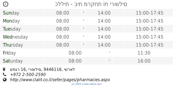
כללית - בית מרקחת
שמגר 16, ירושלים
Pharmacy
read more
14.401 km
Meuhedet
Panim Meirot Street 16, Jerusalem
Pharmacy
read more
14.551 km
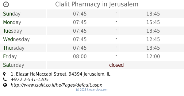
Clalit Pharmacy
Elazar HaMaccabi Street 1, Jerusalem
Pharmacy
read more
14.569 km
Поликлиника Клалит
HaMem Gimel Street 28, Jerusalem
Pharmacy
read more
14.718 km
Clalit Pharmacy
Me'a She'arim Street 83, Jerusalem
Pharmacy
read more
14.718 km
Поликлиника Клалит
Me'a She'arim Street 83, Jerusalem
Pharmacy
read more
14.777 km
Rina Pharm
David Yellin Street 31, Jerusalem
Pharmacy
read more
14.811 km
Batish Madisayev
Jerusalem
Pharmacy
read more
14.931 km
Супер-Фарм
תחנה מרכזית, יפו 234, ירושלים
Pharmacy
read more
15.037 km
Ha'Amudim
Jerusalem
Pharmacy
read more
15.058 km
מול בנייני האומה
Sderot Shazar, Jerusalem
Pharmacy
read more
15.06 km
סנטר פארם פעמון
ירושלים
Pharmacy
read more
15.06 km
Pa'amon Center Pharm
Jerusalem
Pharmacy
read more
15.146 km
Assuta
Jerusalem
Pharmacy
read more
15.171 km
סופר-פארם יפו ירושלים
יפו 29, ירושלים
Pharmacy
read more
15.56 km
מדי פלוס גבעת שאול
כנפי נשרים 10, ירושלים
Pharmacy
read more
15.56 km
Giv'at Sha'ul Medi Plus
Kanfei Nesharim Street 10, Jerusalem
Pharmacy
read more
15.709 km
סופר-פארם גבעת שאול
כנפי נשרים 22, ירושלים
Pharmacy
read more
16.136 km
כללית - בית מרקחת
Shim'on Swisa Street 61, Mevaseret Zion
Pharmacy
read more
📑
all categories
Accounting
Administrative area level 1
Administrative area level 2
Airport
Amusement park
Aquarium
Art gallery
Atm
Bakery
Bank
Bar
Beauty salon
Bicycle store
Book store
Bowling alley
Bus station
Cafe
Campground
Car dealer
Car rental
Car repair
Car wash
Casino
Cemetery
Church
City hall
Clothing store
Colloquial area
Convenience store
Country
Courthouse
Dentist
Department store
Doctor
Electrician
Electronics store
Embassy
Establishment
Finance
Fire station
Florist
Food
Funeral home
Furniture store
Gas station
General contractor
Grocery or supermarket
Gym
Hair care
Hardware store
Health
Hindu Temple
Home goods store
Hospital
Insurance agency
Intersection
Jewelry store
Laundry
Lawyer
Library
Light rail station
Liquor store
Local government office
Locality
Locksmith
Lodging
Meal delivery
Meal takeaway
Mosque
Movie rental
Movie theater
Moving company
Museum
Natural feature
Neighborhood
Night club
Painter
Park
Parking
Pet store
Pharmacy
Physiotherapist
Place of worship
Plumber
Point of interest
Police
Political
Post office
Premise
Real estate agency
Restaurant
Roofing contractor
Route
Rv park, camping
School
Shoe store
Shopping mall
Spa
Stadium
Storage
Store
Subpremise
Subway station
Supermarket
Synagogue
Taxi stand
Train station
Transit station
Travel agency
University
Veterinary care
Zoo
administrative area level 3
administrative area level 4
sublocality level 1
↑