Pharmacy nearby Clalit Pharmacy
Israel
Pharmacy nearby Clalit Pharmacy
Clalit Pharmacy
מרכז מסחרי, צבי בורנשטיין 1, ירוחם Israel
contacts phone
:
+972
Latitude:
30.9878617
, Longitude:
34.9292548
read more
nearest Pharmacy
כללית בית מרקחת
מרכז מסחרי, צבי בורנשטיין 1, ירוחם
Pharmacy
read more
Поликлиника Клалит
מרכז מסחרי, צבי בורנשטיין 1, ירוחם
Pharmacy
read more
94 m
פארם ירוחם
צבי בורנשטיין, ירוחם
Pharmacy
read more
679 m
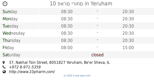
10 פארם ירוחם
נחל צין 37, ירוחם
Pharmacy
read more
679 m
10 פארם ירוחם
Nakhal Tsin Street 37, Yeruham
Pharmacy
read more
11.822 km
סופר-פארם דימונה
אזור תעשייה 395, דימונה
Pharmacy
read more
11.822 km
Super-Pharm
אזור תעשייה 395, דימונה
Pharmacy
read more
12.943 km
Ilan
Dimona
Pharmacy
read more
12.96 km
Макаби. Медицинский центр Димона
Sderot Yig'al Alon 1, Dimona
Pharmacy
read more
12.96 km
Maccabi Dimona
Sderot Yig'al Alon 1, Dimona
Pharmacy
read more
12.96 km
בית מרקחת מכבי דימונה
שדרות יגאל אלון 1, דימונה
Pharmacy
read more
13.189 km
Clalit Pharmacy
Leon Birenbo'im Street, דימונה, ישראל
Pharmacy
read more
20.541 km
גרין פארמסי . Green Pharmacy
ערערה בנגב
Pharmacy
read more
20.541 km
גרין פארמסי . Green Pharmacy
Ar'arat an-Naqab
Pharmacy
read more
20.591 km
כללית_בית מרקחת
129, Ar'arat an-Naqab
Pharmacy
read more
20.591 km
כללית_בית מרקחת
129, ערערה בנגב
Pharmacy
read more
20.834 km
Estintor
רביבים
Pharmacy
read more
20.834 km
Estintor
Revivim
Pharmacy
read more
22.002 km
Mapi Pharma Soute
Rakefet Street, Ramat Hovav
Pharmacy
read more
30.884 km
Hanegev Pharmacy
Kakal Street 94, Be'er Sheva
Pharmacy
read more
33.571 km
Поликлиника Клалит
רחבת השל"ה 18, באר שבע
Pharmacy
read more
33.817 km
סופר-פארם קניון אביה
קניון אביה, שאול המלך 38, באר שבע
Pharmacy
read more
47.626 km
صيدلية السموع - رابعة الدغامين
السموع وسط البلد - عمارة البص, as-Samu
Pharmacy
read more
47.938 km
כללית - בית מרקחת
השלום, רהט
Pharmacy
read more
57.981 km
סופר-פארם נתיבות
Netivot
Pharmacy
read more
📑
all categories
Accounting
Administrative area level 1
Administrative area level 2
Airport
Amusement park
Aquarium
Art gallery
Atm
Bakery
Bank
Bar
Beauty salon
Bicycle store
Book store
Bowling alley
Bus station
Cafe
Campground
Car dealer
Car rental
Car repair
Car wash
Casino
Cemetery
Church
City hall
Clothing store
Colloquial area
Convenience store
Country
Courthouse
Dentist
Department store
Doctor
Electrician
Electronics store
Embassy
Establishment
Finance
Fire station
Florist
Food
Funeral home
Furniture store
Gas station
General contractor
Grocery or supermarket
Gym
Hair care
Hardware store
Health
Hindu Temple
Home goods store
Hospital
Insurance agency
Intersection
Jewelry store
Laundry
Lawyer
Library
Light rail station
Liquor store
Local government office
Locality
Locksmith
Lodging
Meal delivery
Meal takeaway
Mosque
Movie rental
Movie theater
Moving company
Museum
Natural feature
Neighborhood
Night club
Painter
Park
Parking
Pet store
Pharmacy
Physiotherapist
Place of worship
Plumber
Point of interest
Police
Political
Post office
Premise
Real estate agency
Restaurant
Roofing contractor
Route
Rv park, camping
School
Shoe store
Shopping mall
Spa
Stadium
Storage
Store
Subpremise
Subway station
Supermarket
Synagogue
Taxi stand
Train station
Transit station
Travel agency
University
Veterinary care
Zoo
administrative area level 3
administrative area level 4
sublocality level 1
↑