Parking nearby חניון אנדרטת השריון
Israel
Parking nearby חניון אנדרטת השריון
חניון אנדרטת השריון
Israel ישראל
contacts phone
:
+972
Latitude:
32.998778
, Longitude:
35.470215
read more
nearest Parking
724 m
חניון באר אוזים
89
Parking
read more
2.416 km
Maron parking
Israel
Parking
read more
2.416 km
חניון מרון
Israel
Parking
read more
3.275 km
Meron position
Israel
Parking
read more
3.62 km
חניון יער ביריה
Israel
Parking
read more
3.756 km
Parking Close To Mikva Ari
Tsahal Street 30, Safed
Parking
read more
4.309 km
חניון הבית בטו
קרן היסוד 45, צפת
Parking
read more
4.309 km
חניון הבית בטו
Keren ha-Yesod Street 45, Safed
Parking
read more
4.402 km
Safed Parking
Aliya Bet Street 6, Safed
Parking
read more
4.492 km
עין זיתים
צפת
Parking
read more
4.541 km
Parking Lot
32°57'51. 35°29'47.1"E, 6, Nahf
Parking
read more
5.222 km
Meron Reserve Parking
Israel
Parking
read more
5.246 km
Shvil ha-Pisga
Israel
Parking
read more
5.699 km
חניון החלמוניות
חצור הגלילית
Parking
read more
5.699 km
Ha-Khelmoniyot Campsite
Hatzor HaGlilit
Parking
read more
6.373 km
The position of Leah and Yitzhak Rabin
Israel
Parking
read more
6.373 km
חניון לאה ויצחק רבין
Israel
Parking
read more
8.016 km
מגרש חניה גדול
ראש פינה
Parking
read more
14.474 km
HaElot Parking Lot
Israel
Parking
read more
15.55 km
חניון נחל קדש
Israel
Parking
read more
15.55 km
Nahal Kadesh Parking Lot
Israel
Parking
read more
16.356 km
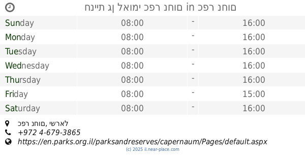
חניית גן לאומי כפר נחום
כפר נחום
Parking
read more
16.356 km
חניית גן לאומי כפר נחום
Capernaum
Parking
read more
17.078 km
Ha-Yarden Reconstructed
Israel
Parking
read more
17.078 km
הירדן המשוחזר
Israel
Parking
read more
📑
all categories
Accounting
Administrative area level 1
Administrative area level 2
Airport
Amusement park
Aquarium
Art gallery
Atm
Bakery
Bank
Bar
Beauty salon
Bicycle store
Book store
Bowling alley
Bus station
Cafe
Campground
Car dealer
Car rental
Car repair
Car wash
Casino
Cemetery
Church
City hall
Clothing store
Colloquial area
Convenience store
Country
Courthouse
Dentist
Department store
Doctor
Electrician
Electronics store
Embassy
Establishment
Finance
Fire station
Florist
Food
Funeral home
Furniture store
Gas station
General contractor
Grocery or supermarket
Gym
Hair care
Hardware store
Health
Hindu Temple
Home goods store
Hospital
Insurance agency
Intersection
Jewelry store
Laundry
Lawyer
Library
Light rail station
Liquor store
Local government office
Locality
Locksmith
Lodging
Meal delivery
Meal takeaway
Mosque
Movie rental
Movie theater
Moving company
Museum
Natural feature
Neighborhood
Night club
Painter
Park
Parking
Pet store
Pharmacy
Physiotherapist
Place of worship
Plumber
Point of interest
Police
Political
Post office
Premise
Real estate agency
Restaurant
Roofing contractor
Route
Rv park, camping
School
Shoe store
Shopping mall
Spa
Stadium
Storage
Store
Subpremise
Subway station
Supermarket
Synagogue
Taxi stand
Train station
Transit station
Travel agency
University
Veterinary care
Zoo
administrative area level 3
administrative area level 4
sublocality level 1
↑