Park nearby Te'hila Garden
Israel
Park nearby Te'hila Garden
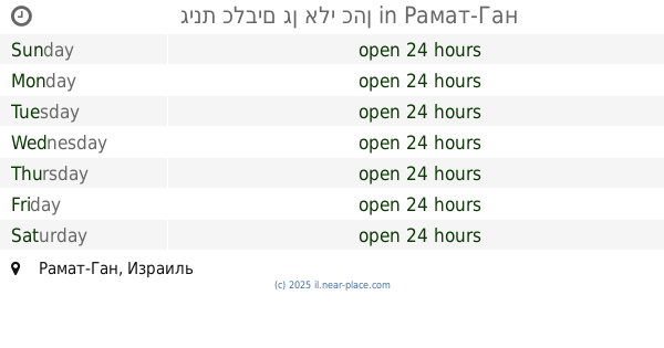
Te'hila Garden
Ramat Gan, Israel
contacts phone
:
+972
Latitude:
32.0649935
, Longitude:
34.8311984
larger map & directions
read more
nearest Park
גן תהילה
רמת גן
Park
read more
350 m
Dror Garden
Ramat Gan
Park
read more
383 m
גן הערמונים
רמת גן
Park
read more
399 m
HaNun Dalet Garden
Ramat Gan
Park
read more
445 m
גינת כלבים גן אלי כהן
Ramat Gan
Park
read more
496 m
Eli Cohen Garden
Рамат-Ган
Park
read more
558 m
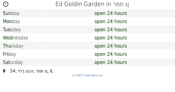
Ed Goldin Garden
דרך נגבה 54, רמת גן
Park
read more
578 m
Hacabaim community garden Ramat Gan
Neveh Yehoshua Street, Ramat Gan
Park
read more
613 m
גן החיל
רמת גן
Park
read more
679 m
Ha-Biluyim Garden
Ramat Gan
Park
read more
689 m
גינת כלבים - מרום נווה
תרצה, רמת גן
Park
read more
707 m
Kindergarten Ramat Gan - a container garden in Ramat Gan
משה דיין 15, Ramat Gan
Park
read more
707 m
גן ילדים ברמת גן - הגן של מיכל ברמת גן
משה דיין 15, רמת גן
Park
read more
718 m
HaEm Garden
Рамат-Ган
Park
read more
746 m
Merom Naveh Park
Ramat Gan
Park
read more
830 m
גינת רימון
בני ברק
Park
read more
830 m
גינת רימון
Bnei Brak
Park
read more
838 m
Ben Tsvi Garden
Рамат-Ган
Park
read more
840 m
Pomegranate Garden
Rabi Yosef Zvi Rimon Street 30-34, Bnei Brak
Park
read more
921 m
גינה קהילתית אמנון ותמר
השושן 2-12, רמת גן
Park
read more
1.11 km
Moshe Garden
Bene Berak
Park
read more
1.157 km
Tsadok Garden
Рамат-Ган
Park
read more
1.186 km
Ha-Admor mi-Kutsk Garden
Бней-Брак
Park
read more
1.186 km
Ha-Admor mi-Kutsk Garden
Bnei Brak
Park
read more
1.195 km
גינת שעשועים
יאיר 34, רמת גן
Park
read more
📑
all categories
Accounting
Administrative area level 1
Administrative area level 2
Airport
Amusement park
Aquarium
Art gallery
Atm
Bakery
Bank
Bar
Beauty salon
Bicycle store
Book store
Bowling alley
Bus station
Cafe
Campground
Car dealer
Car rental
Car repair
Car wash
Casino
Cemetery
Church
City hall
Clothing store
Colloquial area
Convenience store
Country
Courthouse
Dentist
Department store
Doctor
Electrician
Electronics store
Embassy
Establishment
Finance
Fire station
Florist
Food
Funeral home
Furniture store
Gas station
General contractor
Grocery or supermarket
Gym
Hair care
Hardware store
Health
Hindu Temple
Home goods store
Hospital
Insurance agency
Intersection
Jewelry store
Laundry
Lawyer
Library
Light rail station
Liquor store
Local government office
Locality
Locksmith
Lodging
Meal delivery
Meal takeaway
Mosque
Movie rental
Movie theater
Moving company
Museum
Natural feature
Neighborhood
Night club
Painter
Park
Parking
Pet store
Pharmacy
Physiotherapist
Place of worship
Plumber
Point of interest
Police
Political
Post office
Premise
Real estate agency
Restaurant
Roofing contractor
Route
Rv park, camping
School
Shoe store
Shopping mall
Spa
Stadium
Storage
Store
Subpremise
Subway station
Supermarket
Synagogue
Taxi stand
Train station
Transit station
Travel agency
University
Veterinary care
Zoo
administrative area level 3
administrative area level 4
sublocality level 1
↑