Park nearby Puente Park Hayarkon
Israel
Park nearby Puente Park Hayarkon
Puente Park Hayarkon
HaRav Kosovsky Street, Tel Aviv-Yafo, IL Израиль
contacts phone
:
+972
Latitude:
32.0993021
, Longitude:
34.8020234
larger map & directions
read more
nearest Park
350 m
Ydidei Tel Aviv Garden
Тель-Авив
Park
read more
548 m
סקיפר בפאר'ק
גני יהושוע , פארק הירקון אגם הגולפיטק, תל אביב יפו
Park
read more
548 m
סקיפר בפאר'ק
גני יהושוע , פארק הירקון אגם הגולפיטק, Tel Aviv-Yafo
Park
read more
554 m
Rosh Tzippor Birdwatching Centre
תל אביב יפו
Park
read more
572 m
גינת יוסף בן פנחס עוזיאל
الحاخام تولدانو, תל אביב יפו
Park
read more
573 m
מרכז צפרות ראש ציפור
תל אביב יפו
Park
read more
573 m
Head bird birding center
Tel Aviv-Yafo
Park
read more
631 m
Парк
תל אביב יפו
Park
read more
655 m
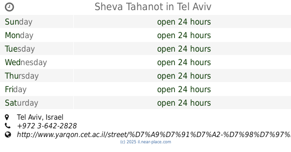
Sheva Tahanot
Tel Aviv-Yafo
Park
read more
715 m
Park Hayarkon Boat Rental
Tel Aviv-Yafo
Park
read more
765 m
גן הרפתקאות
תל אביב יפו
Park
read more
765 m
Adventures Garden
Tel Aviv-Jaffa
Park
read more
773 m
Abramovich Garden
Tel Aviv-Yafo
Park
read more
838 m
אגם הפארק
גני יהושע, שדות רוקח, תל אביב יפו
Park
read more
881 m
Zinger Garden
Тель-Авив
Park
read more
930 m
גן החרוזים
תל אביב יפו
Park
read more
930 m
Ha-Kharuzim Garden
Tel Aviv-Yafo
Park
read more
944 m
Парк Яркон
Tel Aviv-Yafo
Park
read more
944 m
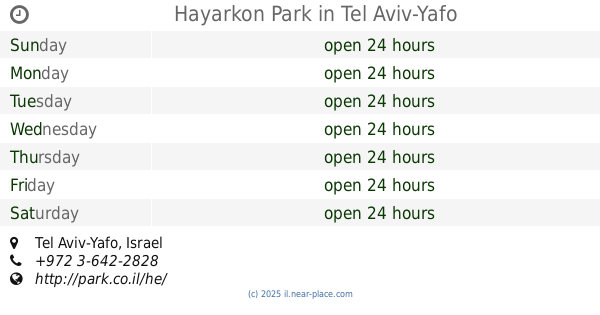
Hayarkon Park
Tel Aviv-Yafo
Park
read more
944 m
Yarkon Park
Tel Aviv-Yafo
Park
read more
944 m
פארק הירקון
תל אביב יפו
Park
read more
1.027 km
Tel Aviv Garden
Тель-Авив
Park
read more
1.027 km
גן תל אביב
תל אביב יפו
Park
read more
1.064 km
Mount Nfolaion
Rokach Street 42-54, Ramat Gan
Park
read more
1.125 km
הגינה של כולנו - הגינה הקהילתית ברמת אביב הירוקה
168, Namir Road 148, Tel Aviv-Yafo
Park
read more
📑
all categories
Accounting
Administrative area level 1
Administrative area level 2
Airport
Amusement park
Aquarium
Art gallery
Atm
Bakery
Bank
Bar
Beauty salon
Bicycle store
Book store
Bowling alley
Bus station
Cafe
Campground
Car dealer
Car rental
Car repair
Car wash
Casino
Cemetery
Church
City hall
Clothing store
Colloquial area
Convenience store
Country
Courthouse
Dentist
Department store
Doctor
Electrician
Electronics store
Embassy
Establishment
Finance
Fire station
Florist
Food
Funeral home
Furniture store
Gas station
General contractor
Grocery or supermarket
Gym
Hair care
Hardware store
Health
Hindu Temple
Home goods store
Hospital
Insurance agency
Intersection
Jewelry store
Laundry
Lawyer
Library
Light rail station
Liquor store
Local government office
Locality
Locksmith
Lodging
Meal delivery
Meal takeaway
Mosque
Movie rental
Movie theater
Moving company
Museum
Natural feature
Neighborhood
Night club
Painter
Park
Parking
Pet store
Pharmacy
Physiotherapist
Place of worship
Plumber
Point of interest
Police
Political
Post office
Premise
Real estate agency
Restaurant
Roofing contractor
Route
Rv park, camping
School
Shoe store
Shopping mall
Spa
Stadium
Storage
Store
Subpremise
Subway station
Supermarket
Synagogue
Taxi stand
Train station
Transit station
Travel agency
University
Veterinary care
Zoo
administrative area level 3
administrative area level 4
sublocality level 1
↑