Park nearby musrara community garden
Israel
Park nearby musrara community garden
musrara community garden
ירושלים, ישראל
contacts phone
:
+972
Latitude:
31.783123
, Longitude:
35.225887
larger map & directions
read more
nearest Park
232 m
HaTsanhanim Garden
Jerozolima
Park
read more
232 m
גן הצנחנים
ירושלים
Park
read more
398 m
Safra Square
Jerusalem
Park
read more
477 m
National Park
Jerusalem
Park
read more
609 m
Zion Square
יפו, ירושלים
Park
read more
609 m
Площадь Сион
Jaffa Street, Jerusalem
Park
read more
639 m
כיכר החתולות
יוסף ריבלין 22, ירושלים
Park
read more
641 m
טיילת החומות
Yafo Street, Jerusalem
Park
read more
641 m
טיילת החומות
יפו, ירושלים
Park
read more
687 m
גינת משחקים
תרמ"ב, ירושלים
Park
read more
732 m
כיכר זוועהיל
Shmu'el ha-Navi Street 28, Jerusalem
Park
read more
847 m
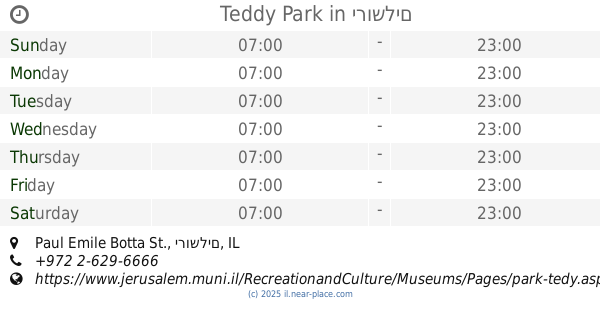
Teddy Park
Paul Emile Botta St., ירושלים
Park
read more
847 m
פארק טדי
Paul Emile Botta St., ירושלים
Park
read more
910 m
גן רוקפלר
ירושלים
Park
read more
922 m
גן העצמאות
גן העצמאות, ירושלים
Park
read more
967 m
גן הסוס
המלך ג'ורג' 18, ירושלים
Park
read more
987 m
הקרן למורשת הכותל המערבי - The Western Wall Heritage Foundation
HaOmer Street 2, Jerusalem
Park
read more
987 m
הקרן למורשת הכותל המערבי - The Western Wall Heritage Foundation
העומר 2, ירושלים
Park
read more
989 m
גן הארמנים
ירושלים
Park
read more
1.035 km
גן מאיר שרמן
ירושלים
Park
read more
1.176 km
לאב-גארדן
נחום ארנפלד 8, Jerusalem
Park
read more
1.188 km
משרדי קק"ל
המלך ג'ורג' פינת קק"ל 48, ירושלים
Park
read more
1.188 km
JNF offices
המלך ג'ורג' פינת קק"ל 48, Jerusalem
Park
read more
1.198 km
גן בית שלום
ירושלים
Park
read more
1.198 km
Beit Shalom Garden
Иерусалим
Park
read more
📑
all categories
Accounting
Administrative area level 1
Administrative area level 2
Airport
Amusement park
Aquarium
Art gallery
Atm
Bakery
Bank
Bar
Beauty salon
Bicycle store
Book store
Bowling alley
Bus station
Cafe
Campground
Car dealer
Car rental
Car repair
Car wash
Casino
Cemetery
Church
City hall
Clothing store
Colloquial area
Convenience store
Country
Courthouse
Dentist
Department store
Doctor
Electrician
Electronics store
Embassy
Establishment
Finance
Fire station
Florist
Food
Funeral home
Furniture store
Gas station
General contractor
Grocery or supermarket
Gym
Hair care
Hardware store
Health
Hindu Temple
Home goods store
Hospital
Insurance agency
Intersection
Jewelry store
Laundry
Lawyer
Library
Light rail station
Liquor store
Local government office
Locality
Locksmith
Lodging
Meal delivery
Meal takeaway
Mosque
Movie rental
Movie theater
Moving company
Museum
Natural feature
Neighborhood
Night club
Painter
Park
Parking
Pet store
Pharmacy
Physiotherapist
Place of worship
Plumber
Point of interest
Police
Political
Post office
Premise
Real estate agency
Restaurant
Roofing contractor
Route
Rv park, camping
School
Shoe store
Shopping mall
Spa
Stadium
Storage
Store
Subpremise
Subway station
Supermarket
Synagogue
Taxi stand
Train station
Transit station
Travel agency
University
Veterinary care
Zoo
administrative area level 3
administrative area level 4
sublocality level 1
↑