Park nearby botanical garden
Israel
Park nearby botanical garden
botanical garden
Ein Gedi, Israel
contacts phone
:
+972 8-659-4726
website:
www.eingedi.co.il
Latitude:
31.450917
, Longitude:
35.3823683
larger map & directions
read more
nearest Park
552 m
Arugot Nature Reserve
Israel
Park
read more
587 m
גן קקטוסים
עין גדי
Park
read more
587 m
Cacti Garden
Jardín Botánico Ein Gedi
Park
read more
587 m
Cacti Garden
Эйн-Геди
Park
read more
1.802 km
Park Narodowy En Gedi
Ein Gedi
Park
read more
1.802 km
Ein Gedi Reserve
Ein Gedi
Park
read more
1.802 km
En Gedi
Ein Gedi
Park
read more
1.802 km
Эйн-Геди
Ein Gedi
Park
read more
1.802 km
שמורת טבע עין גדי
עין גדי
Park
read more
2.036 km
David River - Entrance
Israel
Park
read more
9.905 km
Nahal Arugot Ili Reserve
Israel
Park
read more
10.531 km
Tsurei HaYe'elim Reserve
Israel
Park
read more
10.531 km
שמורת צורי היעלים
Israel
Park
read more
12.304 km
Ein Namer (עין נמר)
31°21'22.8"N 35°18'54., Israel's 3, Jerusalem
Park
read more
13.064 km
גן יצחק רבין
מצפה שלם
Park
read more
18.514 km
Rahaf Stream נחל רחף
Israel
Park
read more
19.79 km
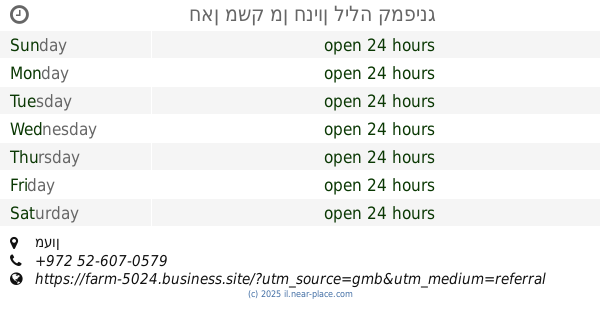
חאן משק מן חניון לילה קמפינג
מעון
Campground
Lodging
Park
Food
Point of interest
Establishment
read more
25.725 km
Irit Garden
Арад
Park
read more
26.1 km
Gan HaVradim Dvora Meyer
Арад
Park
read more
26.735 km
גן חן
ערד
Park
read more
26.876 km
Blue eye gene
Ein HaTchelet Street 5, Arad
Park
read more
26.948 km
גן אגס
אגס, ערד
Park
read more
27.117 km
Halamish Park
Netiv Tamar 7, Arad
Park
read more
28.01 km
גן נחל
Nahal Street 24, Arad
Park
read more
28.061 km
גן מפל
מפל 21, ערד
Park
read more
📑
all categories
Accounting
Administrative area level 1
Administrative area level 2
Airport
Amusement park
Aquarium
Art gallery
Atm
Bakery
Bank
Bar
Beauty salon
Bicycle store
Book store
Bowling alley
Bus station
Cafe
Campground
Car dealer
Car rental
Car repair
Car wash
Casino
Cemetery
Church
City hall
Clothing store
Colloquial area
Convenience store
Country
Courthouse
Dentist
Department store
Doctor
Electrician
Electronics store
Embassy
Establishment
Finance
Fire station
Florist
Food
Funeral home
Furniture store
Gas station
General contractor
Grocery or supermarket
Gym
Hair care
Hardware store
Health
Hindu Temple
Home goods store
Hospital
Insurance agency
Intersection
Jewelry store
Laundry
Lawyer
Library
Light rail station
Liquor store
Local government office
Locality
Locksmith
Lodging
Meal delivery
Meal takeaway
Mosque
Movie rental
Movie theater
Moving company
Museum
Natural feature
Neighborhood
Night club
Painter
Park
Parking
Pet store
Pharmacy
Physiotherapist
Place of worship
Plumber
Point of interest
Police
Political
Post office
Premise
Real estate agency
Restaurant
Roofing contractor
Route
Rv park, camping
School
Shoe store
Shopping mall
Spa
Stadium
Storage
Store
Subpremise
Subway station
Supermarket
Synagogue
Taxi stand
Train station
Transit station
Travel agency
University
Veterinary care
Zoo
administrative area level 3
administrative area level 4
sublocality level 1
↑