Night club nearby Radio EPGB
Israel
Night club nearby Radio EPGB
Radio EPGB
7, שד"ל, 65781, תל אביב יפו, IL ישראל
contacts phone
:
+972 3-560-3636
Latitude:
32.0630658
, Longitude:
34.7750995
larger map & directions
read more
nearest Night club
96 m
KULI ALMA
Mikveh Israel Street 10, Tel Aviv-Yafo
Night club
read more
185 m
Alphabet
אחד העם, תל אביב יפו
Night club
read more
239 m
The Penguin
Yehuda ha-Levi Street 43, Tel Aviv-Yafo
Night club
read more
296 m
Speakeasy
Rothschild Boulevard 24, Tel Aviv-Yafo
Night club
read more
336 m
Drama club
נחלת בנימין 52, תל אביב יפו
Night club
read more
360 m
Salsacarlos
HaSharon Street 19, Tel Aviv-Yafo
Night club
read more
360 m
Salsacarlos
השרון 19, תל אביב יפו
Night club
read more
377 m
בראסקו BRASCO
השרון 12, תל אביב יפו
Night club
read more
385 m
מועדון לאירועים בראסקו BRASCO
HaSharon Street 12, Tel Aviv-Yafo
Night club
read more
459 m
DJ Ron Tesler
Tel Aviv-Yafo
Night club
read more
479 m
Pazas
Allenby Street 94, Tel Aviv-Yafo
Night club
read more
479 m
Pazas
אלנבי 94, תל אביב יפו
Night club
read more
523 m
אחוזת קלישר
קלישר 46, תל אביב יפו
Night club
read more
688 m
אלכס
Zevulun Street 46, Tel Aviv-Yafo
Night club
read more
808 m
מועדון אמור
10, HaTsfira Street, Tel Aviv-Yafo
Night club
read more
877 m
Джельсомино и Друзья
Carlebach Street 3, Tel Aviv-Yafo
Night club
read more
884 m
זיזי טריפו
Carlebach Street 7, Tel Aviv-Yafo
Night club
read more
1.043 km
הקומפורט 13
קומפרט 13, תל אביב יפו
Night club
read more
1.125 km
Fake News Club
Giv'on Street 8, Tel Aviv-Yafo
Night club
read more
1.125 km
Fake News Club
גבעון 8, תל אביב יפו
Night club
read more
1.145 km
Dungeon
HaArba'a Street 10, Tel Aviv-Yafo
Night club
read more
1.153 km
Gagarin
Salame 46, תל אביב יפו
Night club
read more
1.153 km
Gagarin Club TLV
Salame 46, תל אביב יפו
Night club
read more
1.254 km
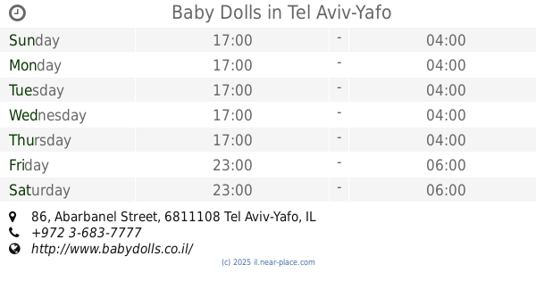
Baby Dolls
Abarbanel Street 86, Tel Aviv-Yafo
Night club
read more
1.299 km
Haoman 17
אברבנל 88, תל אביב יפו
Night club
read more
📑
all categories
Accounting
Administrative area level 1
Administrative area level 2
Airport
Amusement park
Aquarium
Art gallery
Atm
Bakery
Bank
Bar
Beauty salon
Bicycle store
Book store
Bowling alley
Bus station
Cafe
Campground
Car dealer
Car rental
Car repair
Car wash
Casino
Cemetery
Church
City hall
Clothing store
Colloquial area
Convenience store
Country
Courthouse
Dentist
Department store
Doctor
Electrician
Electronics store
Embassy
Establishment
Finance
Fire station
Florist
Food
Funeral home
Furniture store
Gas station
General contractor
Grocery or supermarket
Gym
Hair care
Hardware store
Health
Hindu Temple
Home goods store
Hospital
Insurance agency
Intersection
Jewelry store
Laundry
Lawyer
Library
Light rail station
Liquor store
Local government office
Locality
Locksmith
Lodging
Meal delivery
Meal takeaway
Mosque
Movie rental
Movie theater
Moving company
Museum
Natural feature
Neighborhood
Night club
Painter
Park
Parking
Pet store
Pharmacy
Physiotherapist
Place of worship
Plumber
Point of interest
Police
Political
Post office
Premise
Real estate agency
Restaurant
Roofing contractor
Route
Rv park, camping
School
Shoe store
Shopping mall
Spa
Stadium
Storage
Store
Subpremise
Subway station
Supermarket
Synagogue
Taxi stand
Train station
Transit station
Travel agency
University
Veterinary care
Zoo
administrative area level 3
administrative area level 4
sublocality level 1
↑