Museum nearby Tel Afek Fortress Antipatris
Coronavirus disease (COVID-19) Situation
confirmed cases
4841772
deaths
12707
Israel
Museum nearby Tel Afek Fortress Antipatris
Tel Afek Fortress Antipatris
Be'er Tuvia, Израиль
contacts phone
:
+972
Latitude:
31.7678208
, Longitude:
34.7810018
larger map & directions
read more
nearest Museum
5.657 km
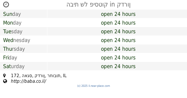
הבית של פיסטוק
האגס 172, קדרון
Museum
read more
5.659 km
מוזיאון בית אור
קדרון
Museum
read more
5.869 km
הצריף הירוק
167,, HaAgas Street 166, Kidron
Museum
read more
6.281 km
זולה טבע
Timorim
Museum
read more
9.779 km
Barn foundations
40, Yesodot
Museum
read more
11.037 km
"תהילה" יודאיקה ומתנות
הגורן 2, מזכרת בתיה
Museum
read more
11.037 km
תהילה יודאיקה ומתנות
HaGoren Street 2, Mazkeret Batya
Museum
read more
12.242 km
Beit Herzl
Israel
Museum
read more
12.277 km
Hulda Forest Memorial vineyards and houses Lishanski
Hulda
Museum
read more
12.858 km
Beit Haedut
דרך ניר גלים, אשדוד
Museum
read more
13.105 km
פח זבל שכונתי
הרב דוד נדב 13, רחובות
Museum
read more
13.105 km
פח זבל שכונתי
Ha-Rav David Nadav Street 13, Rehovot
Museum
read more
13.707 km
בית אריה קלנג
יאיר 2, אשדוד
Museum
read more
13.707 km
Arie Klang House (Artists Gallery)
Yair Street 2, Ashdod
Museum
read more
13.741 km
מרכז הדולפין והים
2 Ort St, Ashdod
Museum
read more
13.75 km
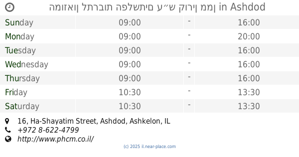
המוזאון לתרבות הפלשתים ע״ש קורין ממן
Ha-Shayatim Street 16, Ashdod
Museum
read more
13.75 km
Музей культуры Филистимлян
Ha-Shayatim Street 16, Ashdod
Museum
read more
13.855 km
מרכז מונארט לאמנויות
דרך ארץ 8, אשדוד
Museum
read more
14.31 km
מרכז מורשת קטיף
ניצן ב'
Museum
read more
14.552 km
Dondikov House
Ya'akov Street 32, Rehovot
Museum
read more
14.706 km
גבעת תום ותומר
Israel
Museum
read more
15.3 km
2nd World War Memorial
א.ד. גורדון 50, רחובות
Museum
read more
15.3 km
2nd World War Memorial
A.D. Gordon Street 50, Rehovot
Museum
read more
15.354 km
Ashdod Ysvne Ponds
Yavne
Museum
read more
17.579 km
מודעיני
Gezer
Museum
read more
📑
all categories
Accounting
Administrative area level 1
Administrative area level 2
Airport
Amusement park
Aquarium
Art gallery
Atm
Bakery
Bank
Bar
Beauty salon
Bicycle store
Book store
Bowling alley
Bus station
Cafe
Campground
Car dealer
Car rental
Car repair
Car wash
Casino
Cemetery
Church
City hall
Clothing store
Colloquial area
Convenience store
Country
Courthouse
Dentist
Department store
Doctor
Electrician
Electronics store
Embassy
Establishment
Finance
Fire station
Florist
Food
Funeral home
Furniture store
Gas station
General contractor
Grocery or supermarket
Gym
Hair care
Hardware store
Health
Hindu Temple
Home goods store
Hospital
Insurance agency
Intersection
Jewelry store
Laundry
Lawyer
Library
Light rail station
Liquor store
Local government office
Locality
Locksmith
Lodging
Meal delivery
Meal takeaway
Mosque
Movie rental
Movie theater
Moving company
Museum
Natural feature
Neighborhood
Night club
Painter
Park
Parking
Pet store
Pharmacy
Physiotherapist
Place of worship
Plumber
Point of interest
Police
Political
Post office
Premise
Real estate agency
Restaurant
Roofing contractor
Route
Rv park, camping
School
Shoe store
Shopping mall
Spa
Stadium
Storage
Store
Subpremise
Subway station
Supermarket
Synagogue
Taxi stand
Train station
Transit station
Travel agency
University
Veterinary care
Zoo
administrative area level 3
administrative area level 4
sublocality level 1
↑