Museum nearby Stalactite Cave Nature Reserve
Israel
Museum nearby Stalactite Cave Nature Reserve
Stalactite Cave Nature Reserve
Israel
contacts phone
:
+972
Latitude:
31.7556126
, Longitude:
35.0232131
larger map & directions
read more
nearest Museum
2.531 km
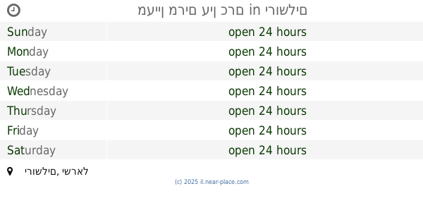
עין פירים
Israel
Museum
read more
2.531 km
Eye shafts
Israel
Museum
read more
2.566 km
מוזיאון המושבה הר-טוב
Israel
Museum
read more
2.575 km
Hartuv Museum
Israel
Museum
read more
2.638 km
The Biblical Museum of Natural History
Ha-Tzaba Street 5, Bet Shemesh
Museum
read more
2.708 km
Bnai brith martyrs forest
Harei Yehuda
Museum
read more
5.606 km
דיר עצפור
בית ג'מאל
Museum
read more
5.677 km
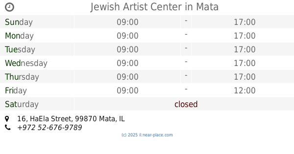
Jewish Artist Center
האלה 16, מטע
Museum
read more
5.677 km
Jewish Artist Center
HaEla Street 16, Mata
Museum
read more
6.806 km
IAA storage facility
HaMelacha Street, Bet Shemesh
Museum
read more
8.264 km
Olya studio
160, Aviezer
Museum
read more
10.029 km
מוזיאון יד לשריון
לטרון
Museum
read more
11.749 km
יער פדויי השבי
Israel National Trail
Museum
read more
13.084 km
בית הגת
דרך האחיות, ירושלים
Museum
read more
13.085 km
מעיין מרים עין כרם
Jerusalem
Museum
read more
13.085 km
מעיין מרים עין כרם
ירושלים
Museum
read more
14.214 km
Botanical Garden, Jerusalem.
Jerusalem
Museum
read more
14.511 km
Beit Herzl
Israel
Museum
read more
14.524 km
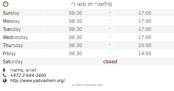
יד ושם
ירושלים
Museum
read more
14.524 km
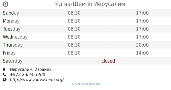
Яд ва-Шем
Jerusalem
Museum
read more
14.566 km
מודעיני
Gezer
Museum
read more
14.64 km
אקווריום ירושלים
Derech Aharon Shulov, Jerusalem
Museum
read more
14.661 km
המרקקה - סניף ירושלים
דרך אהרן שולוב, ירושלים
Museum
read more
14.706 km
עין יעל
ירושלים
Museum
read more
16.299 km
Barn foundations
40, Yesodot
Museum
read more
📑
all categories
Accounting
Administrative area level 1
Administrative area level 2
Airport
Amusement park
Aquarium
Art gallery
Atm
Bakery
Bank
Bar
Beauty salon
Bicycle store
Book store
Bowling alley
Bus station
Cafe
Campground
Car dealer
Car rental
Car repair
Car wash
Casino
Cemetery
Church
City hall
Clothing store
Colloquial area
Convenience store
Country
Courthouse
Dentist
Department store
Doctor
Electrician
Electronics store
Embassy
Establishment
Finance
Fire station
Florist
Food
Funeral home
Furniture store
Gas station
General contractor
Grocery or supermarket
Gym
Hair care
Hardware store
Health
Hindu Temple
Home goods store
Hospital
Insurance agency
Intersection
Jewelry store
Laundry
Lawyer
Library
Light rail station
Liquor store
Local government office
Locality
Locksmith
Lodging
Meal delivery
Meal takeaway
Mosque
Movie rental
Movie theater
Moving company
Museum
Natural feature
Neighborhood
Night club
Painter
Park
Parking
Pet store
Pharmacy
Physiotherapist
Place of worship
Plumber
Point of interest
Police
Political
Post office
Premise
Real estate agency
Restaurant
Roofing contractor
Route
Rv park, camping
School
Shoe store
Shopping mall
Spa
Stadium
Storage
Store
Subpremise
Subway station
Supermarket
Synagogue
Taxi stand
Train station
Transit station
Travel agency
University
Veterinary care
Zoo
administrative area level 3
administrative area level 4
sublocality level 1
↑