Museum nearby כפר סבא
Israel
Museum nearby כפר סבא
כפר סבא
הבנים20, Израиль
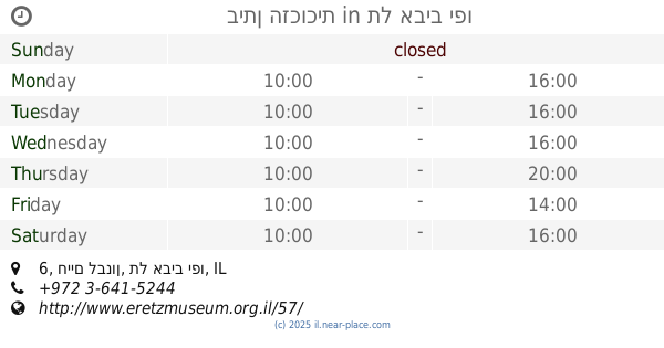
contacts phone
:
+972
Latitude:
32.1733758
, Longitude:
34.9125582
larger map & directions
read more
nearest Museum
481 m
House of Carmela and Abraham Shabat
Rothschild Street 59, Kefar Sava
Museum
read more
481 m
בית כרמלה ואברהם שבת
רוטשילד 59, כפר סבא
Museum
read more
778 m
המוזיאון הארכיאולוגי
קרית ספיר, ירושלים 35, כפר סבא
Museum
read more
778 m
Kfar Saba Museum
קרית ספיר, ירושלים 35, כפר סבא
Museum
read more
778 m
Antiquities Museum
קרית ספיר, ירושלים 35, כפר סבא
Museum
read more
799 m
היכל התרבות כפר סבא
Jerusalem Street 33, Kefar Sava
Museum
read more
799 m
היכל התרבות כפר סבא
ירושלים 33, כפר סבא
Museum
read more
1.389 km
בית האמנים
אז"ר 29, כפר סבא
Museum
read more
1.389 km
בית האמנים
Azar Street 29, Kefar Sava
Museum
read more
2.96 km
המוזיאון - חדר בריחה escape plan
בני ברית 8, הוד השרון
Museum
read more
2.96 km
The museum - room escape escape plan
Bnei Brit Street 8, Hod Hasharon
Museum
read more
4.682 km
איכס פג תוקף בשקל
החי"ל 39, רעננה
Museum
read more
4.682 km
איכס פג תוקף בשקל
HaHayil Street 39, Ra'anana
Museum
read more
7.279 km
Communications Museum
כנפי נשרים 1, Herzliya
Museum
read more
9.917 km
מוזיאון משואה
תל יצחק
Museum
read more
10.481 km
מוזיאון פתח תקוה לאמנות
חיים ארלוזורוב 30, פתח תקווה
Museum
read more
13.138 km
Музей Пальмах
בית הפלמ"ח, חיים לבנון 10, תל אביב יפו
Museum
read more
13.428 km
ביתן הזכוכית
חיים לבנון 6, תל אביב יפו
Museum
read more
16.482 km
Ben-Gurion House
Sderot Ben Gurion 17, Tel Aviv-Yafo
Museum
read more
17.392 km
בית ביאליק
Bialik St. 22, תל אביב יפו
Museum
read more
17.822 km
מדרחוב נחלת בנימין
Nahalat Binyamin Street, Tel Aviv-Yafo
Museum
read more
18.002 km
Музей Хагана
Rothschild Boulevard 23, Tel Aviv-Yafo
Museum
read more
18.06 km
Taglit Birthright "State of Mind" Israel Innovation Center
Ahuzat Bayit Street 2, Tel Aviv-Yafo
Museum
read more
18.427 km
Aden Jewish Heritage Museum
לילינבלום 5, תל אביב יפו
Museum
read more
20.555 km
לונדע
בארשבע
Museum
read more
📑
all categories
Accounting
Administrative area level 1
Administrative area level 2
Airport
Amusement park
Aquarium
Art gallery
Atm
Bakery
Bank
Bar
Beauty salon
Bicycle store
Book store
Bowling alley
Bus station
Cafe
Campground
Car dealer
Car rental
Car repair
Car wash
Casino
Cemetery
Church
City hall
Clothing store
Colloquial area
Convenience store
Country
Courthouse
Dentist
Department store
Doctor
Electrician
Electronics store
Embassy
Establishment
Finance
Fire station
Florist
Food
Funeral home
Furniture store
Gas station
General contractor
Grocery or supermarket
Gym
Hair care
Hardware store
Health
Hindu Temple
Home goods store
Hospital
Insurance agency
Intersection
Jewelry store
Laundry
Lawyer
Library
Light rail station
Liquor store
Local government office
Locality
Locksmith
Lodging
Meal delivery
Meal takeaway
Mosque
Movie rental
Movie theater
Moving company
Museum
Natural feature
Neighborhood
Night club
Painter
Park
Parking
Pet store
Pharmacy
Physiotherapist
Place of worship
Plumber
Point of interest
Police
Political
Post office
Premise
Real estate agency
Restaurant
Roofing contractor
Route
Rv park, camping
School
Shoe store
Shopping mall
Spa
Stadium
Storage
Store
Subpremise
Subway station
Supermarket
Synagogue
Taxi stand
Train station
Transit station
Travel agency
University
Veterinary care
Zoo
administrative area level 3
administrative area level 4
sublocality level 1
↑