Museum nearby Excavations at Beit Guvrin
Israel
Museum nearby Excavations at Beit Guvrin
Excavations at Beit Guvrin
Beit Guvrin, Израиль
contacts phone
:
+972
Latitude:
31.6124029
, Longitude:
34.9021727
larger map & directions
read more
nearest Museum
9.551 km
Valley of Elah
Israel
Museum
read more
10.736 km
מוזיאון היו זמנים
כיסופים 15, בני דקלים
Museum
read more
10.736 km
מוזיאון היו זמנים
Kisufim Street 15, Bnei Dkalim
Museum
read more
11.265 km
Moraq Roman Palace
Muraq, Dura, Hebron
Museum
read more
12.744 km
חווידע
שדרות לכיש 48, קרית גת
Museum
read more
12.744 km
חווידע
Sderot Lachish 48, Kiryat Gat
Museum
read more
13.153 km
Olya studio
160, Aviezer
Museum
read more
14.14 km
IAA storage facility
HaMelacha Street, Bet Shemesh
Museum
read more
14.316 km
דיר עצפור
בית ג'מאל
Museum
read more
14.733 km
The Israel Police Heritage Museum
המכללה הלאומית לשוטרים, אזור תעשייה מערב, בית שמש
Museum
read more
16.875 km
متحف الشهيد ابو شرار
البنوك, Ya'akov Dori Street, Modi'in-Maccabim-Re'ut
Museum
read more
17.393 km
זולה טבע
Timorim
Museum
read more
17.393 km
זולה טבע
תימורים
Museum
read more
18.843 km
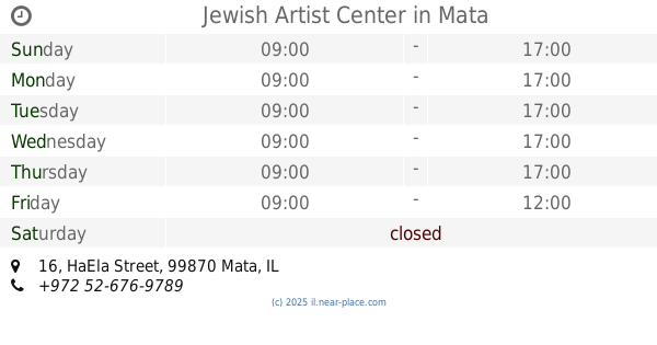
Jewish Artist Center
HaEla Street 16, Mata
Museum
read more
18.843 km
Jewish Artist Center
האלה 16, מטע
Museum
read more
20.208 km
Eye shafts
Israel
Museum
read more
20.208 km
עין פירים
Israel
Museum
read more
21.39 km
מרכז המבקרים לגעת בנצח
בית הדסה, חברון
Museum
read more
22.285 km
גבעת תום ותומר
Israel
Museum
read more
23.01 km
Barn foundations
40, Yesodot
Museum
read more
24.108 km
Украінський ліс
Israel
Museum
read more
24.829 km
הבית של פיסטוק
האגס 172, קדרון
Museum
read more
24.964 km
הצריף הירוק
167,, HaAgas Street 166, Kidron
Museum
read more
29.823 km
מעיין מרים עין כרם
Jerusalem
Museum
read more
29.823 km
מעיין מרים עין כרם
ירושלים
Museum
read more
📑
all categories
Accounting
Administrative area level 1
Administrative area level 2
Airport
Amusement park
Aquarium
Art gallery
Atm
Bakery
Bank
Bar
Beauty salon
Bicycle store
Book store
Bowling alley
Bus station
Cafe
Campground
Car dealer
Car rental
Car repair
Car wash
Casino
Cemetery
Church
City hall
Clothing store
Colloquial area
Convenience store
Country
Courthouse
Dentist
Department store
Doctor
Electrician
Electronics store
Embassy
Establishment
Finance
Fire station
Florist
Food
Funeral home
Furniture store
Gas station
General contractor
Grocery or supermarket
Gym
Hair care
Hardware store
Health
Hindu Temple
Home goods store
Hospital
Insurance agency
Intersection
Jewelry store
Laundry
Lawyer
Library
Light rail station
Liquor store
Local government office
Locality
Locksmith
Lodging
Meal delivery
Meal takeaway
Mosque
Movie rental
Movie theater
Moving company
Museum
Natural feature
Neighborhood
Night club
Painter
Park
Parking
Pet store
Pharmacy
Physiotherapist
Place of worship
Plumber
Point of interest
Police
Political
Post office
Premise
Real estate agency
Restaurant
Roofing contractor
Route
Rv park, camping
School
Shoe store
Shopping mall
Spa
Stadium
Storage
Store
Subpremise
Subway station
Supermarket
Synagogue
Taxi stand
Train station
Transit station
Travel agency
University
Veterinary care
Zoo
administrative area level 3
administrative area level 4
sublocality level 1
↑