Museum nearby Candle Factory
Israel
Museum nearby Candle Factory
Candle Factory
1, HaRav Maimon Street, Ashkelon, Ashkelon, IL Израиль
contacts phone
:
+972
Latitude:
31.6539533
, Longitude:
34.5642902
larger map & directions
read more
nearest Museum
1.96 km
Ashkelon National Park
Ashkelon Street, Tel Aviv-Yafo
Museum
read more
2.203 km
בית מוזיאון אילנה שפיר
Ashkelon
Museum
read more
2.203 km
בית מוזיאון אילנה שפיר
אשקלון
Museum
read more
9.962 km
אנדרטת גדוד 52 גבעתי
Israel
Museum
read more
10.672 km
פארק הידידות מטרו ווסט ארז
Erez
Museum
read more
10.672 km
פארק הידידות מטרו ווסט ארז
ארז
Museum
read more
10.772 km
Giv'at Tom and Tomer
Israel
Museum
read more
10.772 km
גבעת תום ותומר
Israel
Museum
read more
11.086 km
מרכז מורשת קטיף
ניצן ב'
Museum
read more
11.388 km
המוזיאון הפתוח נגבה
נגבה
Museum
read more
13.122 km
The Palestinian association for development and heritage protection
Beit Lahia
Museum
read more
13.129 km
The Palestinian Society for the Protection and Development Altart
Beit Lahia
Museum
read more
16.245 km
مركز جابر للكمبيوتر
Palestine, Giza
Museum
read more
16.297 km
محمد صلاح ابو مهند حوت المنطقة
بركة الشيخ رضوان
Museum
read more
16.592 km
مسجد التوحيد
דרך עזה, ירושלים
Museum
read more
16.592 km
مسجد التوحيد
Azza Street, Jerusalem
Museum
read more
16.706 km
Памятник Героям Танкистам
Ashdod
Museum
read more
16.814 km
מרכז מונארט לאמנויות
דרך ארץ 8, אשדוד
Museum
read more
17.609 km
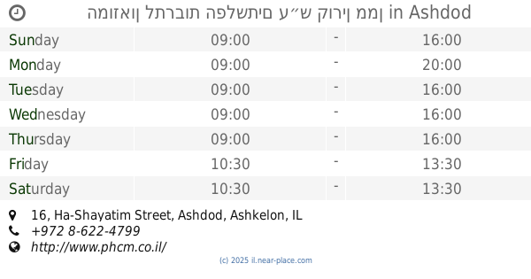
Музей культуры Филистимлян
Ha-Shayatim Street 16, Ashdod
Museum
read more
17.609 km
המוזאון לתרבות הפלשתים ע״ש קורין ממן
Ha-Shayatim Street 16, Ashdod
Museum
read more
17.867 km
Украінський ліс
Israel
Museum
read more
18.442 km
تراث غزة والقدس
Omar Mukhtar Street
Museum
read more
19.736 km
חווידע
שדרות לכיש 48, קרית גת
Museum
read more
28.483 km
הבית של פיסטוק
האגס 172, קדרון
Museum
read more
28.684 km
הצריף הירוק
167,, HaAgas Street 166, Kidron
Museum
read more
📑
all categories
Accounting
Administrative area level 1
Administrative area level 2
Airport
Amusement park
Aquarium
Art gallery
Atm
Bakery
Bank
Bar
Beauty salon
Bicycle store
Book store
Bowling alley
Bus station
Cafe
Campground
Car dealer
Car rental
Car repair
Car wash
Casino
Cemetery
Church
City hall
Clothing store
Colloquial area
Convenience store
Country
Courthouse
Dentist
Department store
Doctor
Electrician
Electronics store
Embassy
Establishment
Finance
Fire station
Florist
Food
Funeral home
Furniture store
Gas station
General contractor
Grocery or supermarket
Gym
Hair care
Hardware store
Health
Hindu Temple
Home goods store
Hospital
Insurance agency
Intersection
Jewelry store
Laundry
Lawyer
Library
Light rail station
Liquor store
Local government office
Locality
Locksmith
Lodging
Meal delivery
Meal takeaway
Mosque
Movie rental
Movie theater
Moving company
Museum
Natural feature
Neighborhood
Night club
Painter
Park
Parking
Pet store
Pharmacy
Physiotherapist
Place of worship
Plumber
Point of interest
Police
Political
Post office
Premise
Real estate agency
Restaurant
Roofing contractor
Route
Rv park, camping
School
Shoe store
Shopping mall
Spa
Stadium
Storage
Store
Subpremise
Subway station
Supermarket
Synagogue
Taxi stand
Train station
Transit station
Travel agency
University
Veterinary care
Zoo
administrative area level 3
administrative area level 4
sublocality level 1
↑