Lodging nearby סעיד כיואן אבו חסן
Israel
Lodging nearby סעיד כיואן אבו חסן
סעיד כיואן אבו חסן
כניסה מערבית, Majd al-Krum, Israel
contacts phone
:
+972
Latitude:
32.9205029
, Longitude:
35.2454074
larger map & directions
read more
nearest Lodging
45 m
מוחמד מנאע
מוחמד מנאע, Majd al-Krum
Lodging
Point of interest
Establishment
read more
146 m
אלטאהר שהאב אלדין
מג'ד אל-כרום
Lodging
read more
146 m
אלטאהר שהאב אלדין
Majd al-Krum
Lodging
read more
889 m
Kibbutz Tuval Country Lodging
Tuval
Lodging
read more
889 m
קיבוץ תובל אירוח כפרי
תובל
Lodging
read more
1.439 km
Bassam Sarhan
Intersection East, Majd al-Krum
Lodging
Point of interest
Establishment
read more
1.639 km
עבד אללה שחאדה
Unnamed Road, Majd al-Krum
Lodging
Point of interest
Establishment
read more
1.918 km
בית נורית
אופיר 1, צורית
Lodging
read more
1.918 km
Beit Nurit
Ofir Street 1, Tzurit
Lodging
read more
2.18 km
צימר צורית
Ha-Sakhlav Street 19, Tzurit
Lodging
read more
2.18 km
צימר צורית
הסחלב 19, צורית
Lodging
read more
3.895 km
אלוטבע
כרמיאל
Lodging
read more
3.895 km
Aluteva
Karmiel
Lodging
Point of interest
Establishment
read more
4.36 km
דירת אירוח מהנשמה צימר בכרמיאל
מישעול, HaSavyonim 29א, Karmiel
Lodging
Point of interest
Establishment
read more
4.468 km
הדס 55 כרמיאל
Hadas Street 55, Karmiel
Lodging
Point of interest
Establishment
read more
4.493 km
וילה מספר 95 - הרשת החברתית
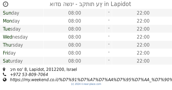
לפידות
Lodging
read more
4.511 km
וילה היימנס בוטיק
האורן 11, לפידות
Lodging
read more
4.527 km
אודם השני
אורן 8, Lapidot
Lodging
read more
4.541 km
אודם השני - בקתות עץ
בית מס' 8, גוש תפן, Lapidot
Lodging
read more
4.541 km
אודם השני - בקתות עץ
בית מס' 8, Lapidot
Lodging
Point of interest
Establishment
read more
4.586 km
Malki House
אורן 6, Lapidot
Lodging
read more
4.604 km
מלכי האוס
לפידות
Lodging
read more
4.701 km
צימרים ביער - שאנטי באורנים
82, Lapidot
Lodging
read more
4.705 km
Shmulik Galilee
Leshem Street 13, Lavon
Lodging
Point of interest
Establishment
read more
4.839 km
בין השמשות
לבון
Lodging
read more
📑
all categories
Accounting
Administrative area level 1
Administrative area level 2
Airport
Amusement park
Aquarium
Art gallery
Atm
Bakery
Bank
Bar
Beauty salon
Bicycle store
Book store
Bowling alley
Bus station
Cafe
Campground
Car dealer
Car rental
Car repair
Car wash
Casino
Cemetery
Church
City hall
Clothing store
Colloquial area
Convenience store
Country
Courthouse
Dentist
Department store
Doctor
Electrician
Electronics store
Embassy
Establishment
Finance
Fire station
Florist
Food
Funeral home
Furniture store
Gas station
General contractor
Grocery or supermarket
Gym
Hair care
Hardware store
Health
Hindu Temple
Home goods store
Hospital
Insurance agency
Intersection
Jewelry store
Laundry
Lawyer
Library
Light rail station
Liquor store
Local government office
Locality
Locksmith
Lodging
Meal delivery
Meal takeaway
Mosque
Movie rental
Movie theater
Moving company
Museum
Natural feature
Neighborhood
Night club
Painter
Park
Parking
Pet store
Pharmacy
Physiotherapist
Place of worship
Plumber
Point of interest
Police
Political
Post office
Premise
Real estate agency
Restaurant
Roofing contractor
Route
Rv park, camping
School
Shoe store
Shopping mall
Spa
Stadium
Storage
Store
Subpremise
Subway station
Supermarket
Synagogue
Taxi stand
Train station
Transit station
Travel agency
University
Veterinary care
Zoo
administrative area level 3
administrative area level 4
sublocality level 1
↑