Lodging nearby פנינת חמד
Israel
Lodging nearby פנינת חמד
פנינת חמד
21, תכלת מרדכי, ירושלים, IL ישראל
contacts phone
:
+972 72-222-3810
website:
www.pninatchemed.com
Latitude:
31.7942423
, Longitude:
35.2079603
larger map & directions
read more
nearest Lodging
פנינת חמד
Tkhelet Mordekhai Street 21, Jerusalem
Lodging
read more
586 m
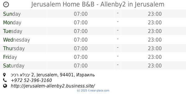
Jerusalem Home B&B - Allenby2
כיכר אלנבי 2, Jerusalem
Lodging
read more
606 m
Allenby 2
Allenby Square 2, Jerusalem
Lodging
read more
627 m
אלנבי 2
31°47'23.0"N 35°12'14., 3, Kiryat Malakhi
Lodging
read more
652 m
קיסר פרימייר ירושלים
רחוב יפו 208, ירושלים
Lodging
read more
673 m
מבוא ירושלים
Jaffa Street 212, Jerusalem
Lodging
read more
694 m
עדי אפרטמנט
מודיעין 25, ירושלים
Lodging
read more
756 m
leonardo jerusalem
Jaffa Street 224, Jerusalem
Lodging
read more
756 m
leonardo jerusalem
יפו 224, ירושלים
Lodging
read more
806 m
Jerusalem Gold Hotel
Jaffa Street 234, Jerusalem
Lodging
read more
833 m
מלון שערי ירושלים
ירמיהו 43, ירושלים
Lodging
read more
833 m
Jerusalem Gate Hotel
Yirmiyahu Street 43, Jerusalem
Lodging
Point of interest
Establishment
read more
851 m
אפרים הוסטל
ירושלים, יפו 234, ירושלים
Lodging
read more
867 m
Avital Hotel
יפו 155, ירושלים
Lodging
read more
885 m
Home in Jerusalem
Oholei Yosef Street 18, Jerusalem
Lodging
read more
885 m
Home in Jerusalem
אוהלי יוסף 18, ירושלים
Lodging
read more
944 m
Beit Avital
Jaffa Street 141, Jerusalem
Lodging
read more
944 m
Beit Avital
Yafo Street 141, Jerusalem
Lodging
read more
1.009 km
So Jerusalem
אליהו מני 6, ירושלים
Lodging
read more
1.103 km
The Residence in Geula
Chafetz Chaim 18 Jerusalem IL 9471021, ירושלים
Lodging
read more
1.103 km
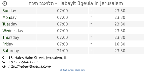
הבית בגאולה - Habayit Bgeula
Hafes Haim Street 16, Jerusalem
Lodging
read more
1.105 km
Gilli Levy
Yehudit Street 4, Jerusalem
Lodging
read more
1.145 km
Head Line
Jerusalem
Lodging
read more
1.149 km
Levy Apartments
Jaffa Street 82, Jerusalem
Lodging
read more
1.177 km
Creactivite
Pri Hadash Street 10, Jerusalem
Lodging
read more
📑
all categories
Accounting
Administrative area level 1
Administrative area level 2
Airport
Amusement park
Aquarium
Art gallery
Atm
Bakery
Bank
Bar
Beauty salon
Bicycle store
Book store
Bowling alley
Bus station
Cafe
Campground
Car dealer
Car rental
Car repair
Car wash
Casino
Cemetery
Church
City hall
Clothing store
Colloquial area
Convenience store
Country
Courthouse
Dentist
Department store
Doctor
Electrician
Electronics store
Embassy
Establishment
Finance
Fire station
Florist
Food
Funeral home
Furniture store
Gas station
General contractor
Grocery or supermarket
Gym
Hair care
Hardware store
Health
Hindu Temple
Home goods store
Hospital
Insurance agency
Intersection
Jewelry store
Laundry
Lawyer
Library
Light rail station
Liquor store
Local government office
Locality
Locksmith
Lodging
Meal delivery
Meal takeaway
Mosque
Movie rental
Movie theater
Moving company
Museum
Natural feature
Neighborhood
Night club
Painter
Park
Parking
Pet store
Pharmacy
Physiotherapist
Place of worship
Plumber
Point of interest
Police
Political
Post office
Premise
Real estate agency
Restaurant
Roofing contractor
Route
Rv park, camping
School
Shoe store
Shopping mall
Spa
Stadium
Storage
Store
Subpremise
Subway station
Supermarket
Synagogue
Taxi stand
Train station
Transit station
Travel agency
University
Veterinary care
Zoo
administrative area level 3
administrative area level 4
sublocality level 1
↑