Lodging nearby Achziv State
Israel
Lodging nearby Achziv State
Achziv State
Израиль
contacts phone
:
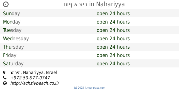
+972 4-982-3219
Latitude:
33.04924
, Longitude:
35.102458
larger map & directions
read more
nearest Lodging
מדינת אכזיב
Israel
Lodging
read more
23 m
Camping Achziv
Israel
Lodging
read more
23 m
קמפינג אכזיב
Israel
Lodging
read more
572 m
achziv beach
Achziv Nahariya
Lodging
read more
586 m
חוף אכזיב
נהריה, Nahariyya
Lodging
read more
586 m
חוף אכזיב
נהריה
Lodging
read more
745 m
SHANZIV
קרית גרשון טץ 1 אכזיב, דירה 406, Nahariyya
Lodging
read more
745 m
SHANZIV
קרית גרשון טץ 1 אכזיב, דירה 406, נהריה
Lodging
read more
839 m
אכסניית מור באכזיב
לימן
Lodging
read more
1.218 km
Gesher HaZiv Tourists Center
Gesher HaZiv
Lodging
read more
1.237 km
Travel Hotel Gesher Haziv
Gesher HaZiv
Lodging
read more
1.272 km
בית ספר שדה אכזיב
Israel
Lodging
read more
1.339 km
טלגוס
סובב לימן, לימן
Lodging
read more
1.369 km
בצמרות הפרדס
לימן
Lodging
read more
1.405 km
צימר ניחוח חציר
HaZayit Street 61, Liman
Lodging
read more
1.405 km
צימר ניחוח חציר
הזית 61, לימן
Lodging
read more
1.414 km
אחוזת דוריתא
HaZayit Street 65, Liman
Lodging
read more
1.638 km
אלמה
מושב לימן, רחוב הזית 72, לימן, גליל מערבי
Lodging
read more
1.745 km
צימר המערב הרגוע
רחוב הגפן 30 לימן IL 22820, הגפן 30, לימן
Lodging
read more
2.02 km
צימרים מקום- בלב
Ha-Tamar Street 15, Liman
Lodging
read more
2.057 km
בקתות המנגו
Liman
Lodging
read more
2.141 km
ביקתפוז וקלמנטינה
Ha-Gefen Street, Liman
Lodging
read more
2.147 km
אחוזת משכית - סוויטות בוטיק במושב לימן
Ha-Gefen Street 20, Liman
Lodging
Restaurant
Food
Health
Point of interest
Establishment
read more
2.237 km
צימר נורטהאוס
לימן
Lodging
read more
2.237 km
צימר נורטהאוס
Liman
Lodging
read more
📑
all categories
Accounting
Administrative area level 1
Administrative area level 2
Airport
Amusement park
Aquarium
Art gallery
Atm
Bakery
Bank
Bar
Beauty salon
Bicycle store
Book store
Bowling alley
Bus station
Cafe
Campground
Car dealer
Car rental
Car repair
Car wash
Casino
Cemetery
Church
City hall
Clothing store
Colloquial area
Convenience store
Country
Courthouse
Dentist
Department store
Doctor
Electrician
Electronics store
Embassy
Establishment
Finance
Fire station
Florist
Food
Funeral home
Furniture store
Gas station
General contractor
Grocery or supermarket
Gym
Hair care
Hardware store
Health
Hindu Temple
Home goods store
Hospital
Insurance agency
Intersection
Jewelry store
Laundry
Lawyer
Library
Light rail station
Liquor store
Local government office
Locality
Locksmith
Lodging
Meal delivery
Meal takeaway
Mosque
Movie rental
Movie theater
Moving company
Museum
Natural feature
Neighborhood
Night club
Painter
Park
Parking
Pet store
Pharmacy
Physiotherapist
Place of worship
Plumber
Point of interest
Police
Political
Post office
Premise
Real estate agency
Restaurant
Roofing contractor
Route
Rv park, camping
School
Shoe store
Shopping mall
Spa
Stadium
Storage
Store
Subpremise
Subway station
Supermarket
Synagogue
Taxi stand
Train station
Transit station
Travel agency
University
Veterinary care
Zoo
administrative area level 3
administrative area level 4
sublocality level 1
↑