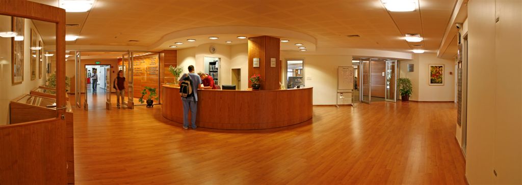
Library nearby ספרייה ציבורית מיתר
Coronavirus disease (COVID-19) Situation
confirmed cases
4841772
deaths
12707
Israel
Library nearby ספרייה ציבורית מיתר
ספרייה ציבורית מיתר
מיתר, ישראל
contacts phone
:
+972 8-651-8370
website:
meitar.library.org.il
Latitude:
31.3267122
, Longitude:
34.9409313
larger map & directions
read more
nearest Library
11.06 km
ספרייה ציבורית עומר
רותם 2, עומר
Library
read more
11.06 km
Omar public library
Rotem Street 2, Omer
Library
read more
15.134 km
Central Library named Zalman Aran
Zalman Aranne Central Library, Be'er Sheva
Library
read more
15.298 km
הספרייה לרפואה ולמדעי הבריאות
Murray Shusterman Medical Library Building, באר שבע
Library
read more
16.099 km
Municipality Library
Derech HaMeshahrerim 12, Be'er Sheva
Library
read more
16.099 km
ספרייה עירונית
דרך המשחררים 12, באר שבע
Library
read more
17.525 km
مكتبة أبجر
Shaqib al-Salam
Library
read more
17.525 km
مكتبة أبجر
שגב שלום שוקייב א סאלם
Library
read more
18.146 km
AACI Southern region Library
Be'er Sheva
Library
read more
22.616 km
ספריהאב
אליאב
Library
read more
24.348 km
مكتبة الاشراقة
Harry Street, Dublin
Library
read more
24.732 km
مكتبة الحسام
Harry Street, Dublin
Library
read more
26.636 km
ספרייה עירונית ערד
Elazar Ben Ya'ir Street 28, Arad
Library
read more
26.636 km
ספרייה עירונית ערד
אלעזר בן יאיר 28, ערד
Library
read more
26.824 km
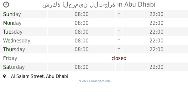
شركة الحرمين للتجارة
Al Salam Street, Abu Dhabi
Library
read more
27.198 km
مكتبة بلدية الخليل
Khaleel El-Masry
Library
read more
28.594 km
مكتبة الابتسامة
Namirah, Riyadh
Library
read more
28.618 km
مكتبة دنديس | Dandis Bookshop
Hebron Road, Jerusalem
Library
read more
39.163 km
ספריה עירונית שדרות
שדרות
Library
read more
40.334 km
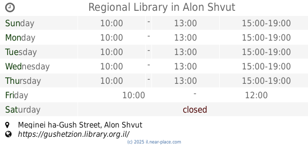
Regional Library
Meginei ha-Gush Street, Alon Shvut
Library
read more
48.874 km
Halabi Library
Jabalia
Library
read more
50.977 km
مطبعة عين
مفترق طموس
Library
read more
51.57 km
Library and see Press
Haret Imam Al Fors
Library
read more
52.512 km
הספריה הרפואית עש ברמן
Muriel and Philip Berman Medical Library, Hebrew University of Jerusalem, P.O.B. 12272, ירושלים
Library
read more
55.858 km
Rehab Library
דרך עזה, ירושלים
Library
read more
📑
all categories
Accounting
Administrative area level 1
Administrative area level 2
Airport
Amusement park
Aquarium
Art gallery
Atm
Bakery
Bank
Bar
Beauty salon
Bicycle store
Book store
Bowling alley
Bus station
Cafe
Campground
Car dealer
Car rental
Car repair
Car wash
Casino
Cemetery
Church
City hall
Clothing store
Colloquial area
Convenience store
Country
Courthouse
Dentist
Department store
Doctor
Electrician
Electronics store
Embassy
Establishment
Finance
Fire station
Florist
Food
Funeral home
Furniture store
Gas station
General contractor
Grocery or supermarket
Gym
Hair care
Hardware store
Health
Hindu Temple
Home goods store
Hospital
Insurance agency
Intersection
Jewelry store
Laundry
Lawyer
Library
Light rail station
Liquor store
Local government office
Locality
Locksmith
Lodging
Meal delivery
Meal takeaway
Mosque
Movie rental
Movie theater
Moving company
Museum
Natural feature
Neighborhood
Night club
Painter
Park
Parking
Pet store
Pharmacy
Physiotherapist
Place of worship
Plumber
Point of interest
Police
Political
Post office
Premise
Real estate agency
Restaurant
Roofing contractor
Route
Rv park, camping
School
Shoe store
Shopping mall
Spa
Stadium
Storage
Store
Subpremise
Subway station
Supermarket
Synagogue
Taxi stand
Train station
Transit station
Travel agency
University
Veterinary care
Zoo
administrative area level 3
administrative area level 4
sublocality level 1
↑