Library nearby Beit Chabad Library
Israel
Library nearby Beit Chabad Library
Beit Chabad Library
10, Einstein Street, Kiryat Ata, Haifa, IL Israel
contacts phone
:
+972 4-845-1888
Latitude:
32.8128664
, Longitude:
35.1137008
larger map & directions
read more
nearest Library
ספריית בית חבד
איינשטיין 10, קרית אתא
Library
read more
756 m
Municipality Library
רמז 14, Kiryat Ata
Library
read more
756 m
ספרייה עירונית
רמז 14, קרית אתא
Library
read more
3.213 km
Municipal Library
Efrayim Street 30, Kiryat Bialik
Library
read more
4.228 km
ספרייה עירונית
דקר 5, קרית מוצקין
Library
read more
4.228 km
Municipal Library
Dakar Street 5, Kiryat Motzkin
Library
read more
4.793 km
ספריה עירונית ע״ש יעקב שטרן
Mohiliver Street 8-12, Haifa
Library
read more
6.889 km
Rekhasim Library
Rekhasim
Library
read more
6.889 km
Rekhasim Library
רכסים
Library
read more
6.909 km
סיפריה ערונית רכסים
הרימונים 27, רכסים
Library
read more
6.909 km
סיפריה ערונית רכסים
Harimonim Street 27, Rekhasim
Library
read more
9.334 km
Math Library
Haifa
Library
read more
9.467 km
Центральная библиотека Эльячар
קמפוס נווה שאנן, קריית הטכניון, חיפה
Library
read more
9.467 km
ספרייה מרכזית טכניון
חיפה
Library
read more
9.51 km
ספרייה עירונית ש.שלום
שדרות טרומפלדור 28, חיפה
Library
read more
10.695 km
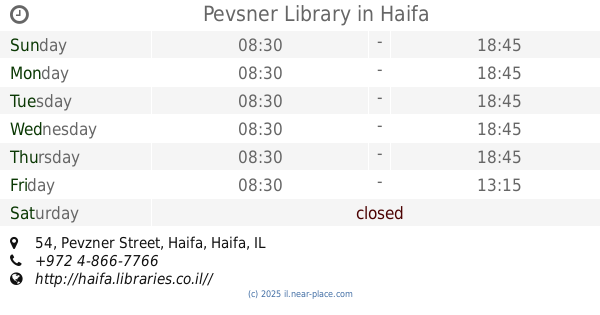
Pevsner Library
Pevzner Street 54, Haifa
Library
read more
11.291 km
Clore Children's Cultural Centre and Library
Haifa
Library
read more
13.217 km
Library of Canada
ויצמן 13, עכו
Library
read more
13.541 km
Library Almoatz
Kafr Manda
Library
read more
14.222 km
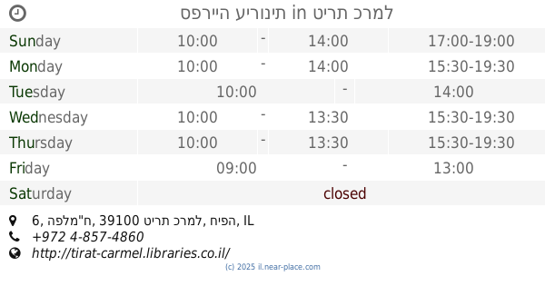
ספרייה עירונית
הפלמ"ח 6, טירת כרמל
Library
read more
14.222 km
Municipal Library Of Tirat Carmel
HaPalmach Street 6, Tirat Carmel
Library
read more
14.249 km
Library and community center Neve David
Haifa
Library
read more
14.564 km
Misgav Regional Council Library
Misgav
Library
read more
15.185 km
ספריית שמשית
Shakham Street 1, Shimshit
Library
read more
15.185 km
ספריית שמשית
שחם 1, שמשית
Library
read more
📑
all categories
Accounting
Administrative area level 1
Administrative area level 2
Airport
Amusement park
Aquarium
Art gallery
Atm
Bakery
Bank
Bar
Beauty salon
Bicycle store
Book store
Bowling alley
Bus station
Cafe
Campground
Car dealer
Car rental
Car repair
Car wash
Casino
Cemetery
Church
City hall
Clothing store
Colloquial area
Convenience store
Country
Courthouse
Dentist
Department store
Doctor
Electrician
Electronics store
Embassy
Establishment
Finance
Fire station
Florist
Food
Funeral home
Furniture store
Gas station
General contractor
Grocery or supermarket
Gym
Hair care
Hardware store
Health
Hindu Temple
Home goods store
Hospital
Insurance agency
Intersection
Jewelry store
Laundry
Lawyer
Library
Light rail station
Liquor store
Local government office
Locality
Locksmith
Lodging
Meal delivery
Meal takeaway
Mosque
Movie rental
Movie theater
Moving company
Museum
Natural feature
Neighborhood
Night club
Painter
Park
Parking
Pet store
Pharmacy
Physiotherapist
Place of worship
Plumber
Point of interest
Police
Political
Post office
Premise
Real estate agency
Restaurant
Roofing contractor
Route
Rv park, camping
School
Shoe store
Shopping mall
Spa
Stadium
Storage
Store
Subpremise
Subway station
Supermarket
Synagogue
Taxi stand
Train station
Transit station
Travel agency
University
Veterinary care
Zoo
administrative area level 3
administrative area level 4
sublocality level 1
↑