Hospital nearby מרכז רפואי אשכול
Israel
Hospital nearby מרכז רפואי אשכול
מרכז רפואי אשכול
ישראל
contacts phone
:
+972
Latitude:
31.239397
, Longitude:
34.4232606
larger map & directions
read more
nearest Hospital
15.803 km
مستشفى دار السلام
شارع صلاح الدين - السطر الشرقي، خان يونس
Hospital
read more
15.922 km
البندر الشرقي
Hospital
read more
16.413 km
مستشفى دار السلام Dar Essalam Hospital
Salah El-Din Street Khan Yunis
Hospital
read more
16.663 km
כללית
רעים
Hospital
read more
16.663 km
Поликлиника Клалит
Re'im
Hospital
read more
16.663 km
כללית
Re'im
Hospital
read more
17.01 km
Palestinian Red Crescent Center
31°20'51.9"N 34°17'48.6"E
Hospital
read more
17.166 km
Al Amal Hospital
4 3، חיפה
Hospital
read more
17.215 km
Mubarak Hospital
31°20'48.2"N 34°17'33.5"E
Hospital
read more
17.263 km
مركز الهلال الاحمر
31°21'06.5"N 34°17'52.5"E
Hospital
read more
17.263 km
Nasser Hospital.
Hospital
read more
17.67 km
Khan Medical Clinic
Hospital
read more
18.298 km
عيادة الحي الاماراتي الطبية
Hospital
read more
18.304 km
UAE health clinic
2 5، Tel Aviv-Yafo
Hospital
read more
18.305 km
Emirati neighborhood clinic
4 6، חיפה
Hospital
read more
20.999 km
مستشفى شهداء الاقصى
Salah El-Din St
Hospital
read more
23.57 km
World Dental Center-Nuseirat Branch
الشارع العام مقابل موقف الزهراء عمارة فرجاللا, Nuseirat Camp
Dentist
Hospital
Health
Point of interest
Establishment
read more
23.598 km
World Dental Center-Nuseirat Branch
Hospital
read more
24.257 km
בית מרקחת מכבי
Ganey Tal Street 2, Netivot
Hospital
Point of interest
Health
Establishment
read more
24.829 km
מרכז הפעלה נתיבות + יחידת אופק נתיבות + מרכז מיון קדמי
Netivot
Hospital
Point of interest
Health
Establishment
read more
26.264 km
Medical Center
Netivot
Hospital
read more
29.791 km
Gaza field hospital of the Jordanian-
الهواء, تل الهوى
Hospital
read more
35.496 km
مستشفي بلسم
GGX9+5MW, Beit Lahia
Hospital
Health
Point of interest
Establishment
read more
35.828 km
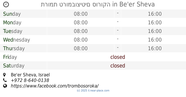
תרומת טרומבוציטים סורוקה
Be'er Sheva
Hospital
read more
51.484 km
Leumit Health Care Services
Sderot Malhei Israel 178, Kiryat Gat
Hospital
read more
📑
all categories
Accounting
Administrative area level 1
Administrative area level 2
Airport
Amusement park
Aquarium
Art gallery
Atm
Bakery
Bank
Bar
Beauty salon
Bicycle store
Book store
Bowling alley
Bus station
Cafe
Campground
Car dealer
Car rental
Car repair
Car wash
Casino
Cemetery
Church
City hall
Clothing store
Colloquial area
Convenience store
Country
Courthouse
Dentist
Department store
Doctor
Electrician
Electronics store
Embassy
Establishment
Finance
Fire station
Florist
Food
Funeral home
Furniture store
Gas station
General contractor
Grocery or supermarket
Gym
Hair care
Hardware store
Health
Hindu Temple
Home goods store
Hospital
Insurance agency
Intersection
Jewelry store
Laundry
Lawyer
Library
Light rail station
Liquor store
Local government office
Locality
Locksmith
Lodging
Meal delivery
Meal takeaway
Mosque
Movie rental
Movie theater
Moving company
Museum
Natural feature
Neighborhood
Night club
Painter
Park
Parking
Pet store
Pharmacy
Physiotherapist
Place of worship
Plumber
Point of interest
Police
Political
Post office
Premise
Real estate agency
Restaurant
Roofing contractor
Route
Rv park, camping
School
Shoe store
Shopping mall
Spa
Stadium
Storage
Store
Subpremise
Subway station
Supermarket
Synagogue
Taxi stand
Train station
Transit station
Travel agency
University
Veterinary care
Zoo
administrative area level 3
administrative area level 4
sublocality level 1
↑