Health nearby שין גי קאן קראטה
Israel
Health nearby שין גי קאן קראטה
שין גי קאן קראטה
74, ארלוזורוב, חיפה, חיפה, IL ישראל
contacts phone
:
+972 4-866-5871
website:
www.shingikan.co.il
Latitude:
32.8072304
, Longitude:
34.9957057
larger map & directions
read more
nearest Health
343 m
Bnai Zion Medical Center/המרכז הרפואי בני ציון
Sderot Eliyahu Golomb 47, Haifa
Hospital
Health
Point of interest
Establishment
read more
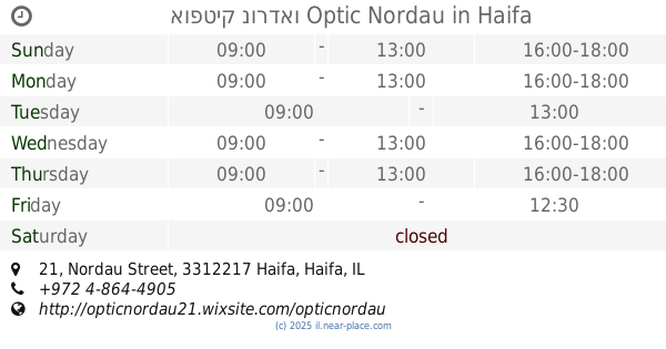
349 m
אופטיק נורדאו Optic Nordau
Nordau Street 21, Haifa
Health
read more
464 m
מרכז לקשיש
Haifa
Health
read more
499 m
מרפאות שיניים דר גלית מטצקי
Ba'al Shem Tov Street 13, Haifa
Dentist
Health
Point of interest
Establishment
read more
582 m
Поликлиника
Herzl Street 73, Haifa
Hospital
Health
Point of interest
Establishment
read more
668 m
מרפאות סגל - מרכז להיפטר מעישון, אלכוהוליזם ומשקל עודף
Ha-Nevi'im Street 20, Haifa
Hospital
Health
Point of interest
Establishment
read more
769 m
Elisha Hospital
Yair Kats Street 12, Haifa
Hospital
Health
Point of interest
Establishment
read more
817 m
מרכז רפואי
Hassan Shuqri Street 5, Haifa
Hospital
Health
Point of interest
Establishment
read more
868 m
Hemdat Avot Home for the Elderly
Haifa
Health
read more
878 m
כללית
יצחק אלחנן 4, חיפה
Health
read more
883 m
אוהד כהן נזנין רפואה משלימה
108, HaNassi Boulevard 100, Haifa
Health
read more
953 m
דר ג'יין רונן
ווג'ווד 6, חיפה
Dentist
Health
Point of interest
Establishment
read more
966 m
המרכז לרפואת הרגל
מגדל הנביאים, Huri 2, Haifa
Hospital
Health
Point of interest
Establishment
read more
990 m
כללית רפואה משלימה חיפה אודיטוריום
שדרות הנשיא 134, חיפה
Health
read more
1.026 km
מכון דגני -אולטרה-סאונד במיילדות וגינקולוגיה
B, האודיטוריום, שדרות הנשיא 134, חיפה
Hospital
Doctor
Health
Point of interest
Establishment
read more
📑
all categories
Accounting
Administrative area level 1
Administrative area level 2
Airport
Amusement park
Aquarium
Art gallery
Atm
Bakery
Bank
Bar
Beauty salon
Bicycle store
Book store
Bowling alley
Bus station
Cafe
Campground
Car dealer
Car rental
Car repair
Car wash
Casino
Cemetery
Church
City hall
Clothing store
Colloquial area
Convenience store
Country
Courthouse
Dentist
Department store
Doctor
Electrician
Electronics store
Embassy
Establishment
Finance
Fire station
Florist
Food
Funeral home
Furniture store
Gas station
General contractor
Grocery or supermarket
Gym
Hair care
Hardware store
Health
Hindu Temple
Home goods store
Hospital
Insurance agency
Intersection
Jewelry store
Laundry
Lawyer
Library
Light rail station
Liquor store
Local government office
Locality
Locksmith
Lodging
Meal delivery
Meal takeaway
Mosque
Movie rental
Movie theater
Moving company
Museum
Natural feature
Neighborhood
Night club
Painter
Park
Parking
Pet store
Pharmacy
Physiotherapist
Place of worship
Plumber
Point of interest
Police
Political
Post office
Premise
Real estate agency
Restaurant
Roofing contractor
Route
Rv park, camping
School
Shoe store
Shopping mall
Spa
Stadium
Storage
Store
Subpremise
Subway station
Supermarket
Synagogue
Taxi stand
Train station
Transit station
Travel agency
University
Veterinary care
Zoo
administrative area level 3
administrative area level 4
sublocality level 1
↑